(FAIRBANKS, Alaska) 7:30 p.m., Saturday (June 8) update – BLM Alaska Fire Service is deploying eight smokejumpers to protect military infrastructure located near Blair Lakes west of the fire. The smokejumpers will remove flammable vegetation and set up hose and water pumps in case the fire threatens the site.
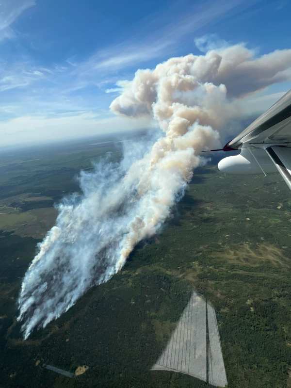
The smoke visible from the Fairbanks and North Pole areas on Saturday originates from a large, wind-driven fire burning in a remote part of a military training range south of Fairbanks. The smoke from the McDonald Fire (#119) will likely be very visible for the upcoming days due to the continued dry, hot conditions.
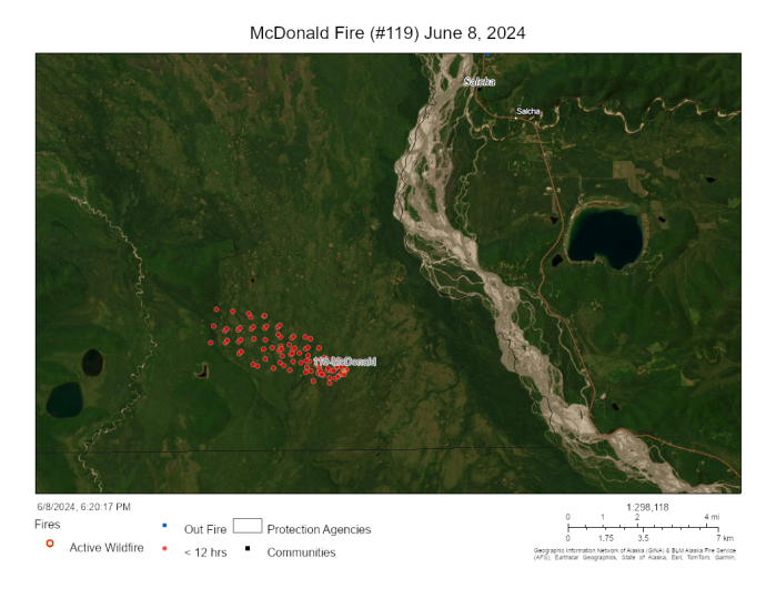
BLM Alaska Fire Service firefighting personnel flew over the fire at around 4:30 p.m., and estimated the fire had burned a stretch of land 3.4 miles long and a quarter of a mile wide, covering 750 acres. The fire, fueled by gusty winds of up to 20 mph from the southeast, was spreading quickly through black spruce on the west side of the Tanana River, approximately 9 miles southwest of Salcha. The wind was pushing the fire deeper into the Tanana Flats Training Area and away from a cluster of cabins located more than five miles southeast of the fire’s head. Winds are expected to subside to 3-7 mph, with gusts up to 7 mph on Sunday, continuing to blow from the east.
The fire was initially reported by a private pilot at about 1:20 p.m. It is burning in an area designated for limited management, meaning that unless the fire threatens property or people, it will be allowed to play its natural ecological role. If the fire threatens a nearby site of value, land and fire managers may mobilize firefighters to protect the site without stopping the wildfire’s spread. This strategy considers firefighter safety, values at risk, and impacts on the surrounding area. Given that the fire is in a large, roadless training area, any firefighting efforts would rely heavily on aviation support. The fire will be monitored by routine flights conducted by BLM Alaska Fire Service Military Fire Management Zone personnel.
The cause of the fire is yet to be determined. There was no military training in that area.
The National Weather Service has issued a Red Flag Warning for most areas north of the Alaska Range to the foothills of the Brooks Range and from the Canadian border to west of McGrath for low humidities, high temperatures and high winds. The Red Flag Warning and Fire Weather Watch will began at 10 a.m. Saturday and extends through 9 p.m. Sunday.
As a result of these conditions the Alaska Division of Forestry & Fire Protection is suspending burn permits in all areas of the Fairbanks Prevention Area beginning Friday, June 7. Permits will be suspended in the Delta and Tok Prevention Areas Saturday and Sunday. The suspensions will be in affect until conditions improve. To see if it’s safe to burn, contact your local burn permit hotline. You can also find more information about the Forestry burn permit program and suspensions.
Contact BLM AFS Public Affairs Specialist Beth Ipsen at (907)356-5510 or eipsen@blm.gov for more information.
###
Bureau of Land Management, Alaska Fire Service, P.O. Box 35005 1541 Gaffney Road, Fort Wainwright, Ak 99703
Need public domain imagery to complement news coverage of the BLM Alaska Fire Service in Alaska? Visit our Flickr channel!
Learn more at www.blm.gov/AlaskaFireService, and on Facebook and Twitter.
The Bureau of Land Management Alaska Fire Service (AFS) located at Fort Wainwright, Alaska, provides wildland fire suppression services for over 240 million acres of Department of the Interior and Native Corporation Lands in Alaska. In addition, AFS has other statewide responsibilities that include: interpretation of fire management policy; oversight of the BLM Alaska Aviation program; fuels management projects; and operating and maintaining advanced communication and computer systems such as the Alaska Lightning Detection System. AFS also maintains a National Incident Support Cache with a $18.1 million inventory. The Alaska Fire Service provides wildland fire suppression services for America’s “Last Frontier” on an interagency basis with the State of Alaska Department of Natural Resources, USDA Forest Service, National Park Service, Bureau of Indian Affairs, U.S. Fish and Wildlife Service, and the U.S. Military in Alaska.
Categories: Active Wildland Fire, AK Fire Info, BLM Alaska Fire Service
