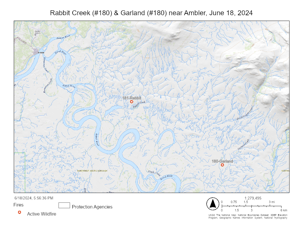
Update for 10 a.m. Wednesday, June 19, 2024: Smokejumpers anticipate having both the Rabbit and Garland fires contained, controlled and extinguished today. At the end of shift Tuesday, the Rabbit Creek (#181) was considered about 75% contained and standing at about 5 acres. Garland Fire is larger at 35 acres.
Update at 10 p.m. on Tuesday, June 18: Smokejumpers and aircraft were deployed to two fires southeast of Ambler and west of the Kobuk River Tuesday afternoon. The Rabbit Creek Fire (#181) and Garland Creek Fire (#180) were reported around 5 p.m. Tuesday, prompting a response from the BLM Alaska Fire Service fire station in Galena. Twelve smokejumpers were evenly split between the two fires.
Additionally, two Fire Boss water scoopers and an additional airplane with personnel to help coordinate the fire’s airspace and relay situational awareness were working to suppress the fires that were burning near Native allotments on the north side of the Kobuk River. The Rabbit Creek Fire, 7 miles southeast of Ambler, burned tundra, brush, and spruce trees within half a mile of a structure. The Garland Creek Fire, 13.5 miles southeast of Ambler, burned in brush and black spruce.Both were estimated at about 5 acres Tuesday evening.
Active thunderstorms in the area could bring rain but also gusty, erratic winds, potentially hindering suppression efforts for these fires.

These are two of the 13 new wildfires reported in Alaska on Tuesday. Most are in remote areas with a limited management option, allowing fires to play their natural ecological role unless they threaten property or people. If a fire endangers people or protected sites like Native allotments, cabins, or critical habitats, firefighters may mobilize to protect these sites without stopping the wildfire’s spread. This strategy prioritizes firefighter safety, values at risk, and the impact on the surrounding area, keeping resources available for new fires that could immediately threaten people and property.
Here are some of the other new fires burning in BLM AFS protection area that covers the northern half of the state.
The Ikheenjik Fire (#184) is burning on BLM-managed land almost 12 miles southeast of Circle Hot Springs and 20 miles southeast of Central on the east side of the Ikheenjik River. It was reported by several people in the area shortly after 6:15 p.m. Firefighting personnel flying over the area reported the fire was very active and burning through black spruce. It is burning in limited management option are and will be monitored.
The Delta Creek (#186) is less than an acre and located on the edge of an area that burned in the 2023 Delta Fire west of the Delta Creek in the Donnelly Training Area. The cause of the fire is undetermined. It is burning in a limited management option area and will be monitored.
The Mud Fire (#179) is burning about 14 miles from the milepost 7 of the Dalton Highway and about 20 miles from where it intersects with the Elliot Highway. It’s about one acre and is visible from the highway. It is burning in a limited management option area and will be monitored.
It was another active day for lightning Tuesday, likely leading to an increase in wildfires in the upcoming days. As of 8:30 p.m. Tuesday, 169 fires have burned approximately 63,000 acres in Alaska.Fire managers from the Alaska Division of Forestry and BLM Alaska Fire Service use aerial detection flights in the days following lightning to search for holdover or sleeper fires.
While lightning often ignites wildfires immediately, some fires, called holdovers or sleepers, don’t appear for days. These fires can smolder below the surface until temperatures warm, vegetation dries, and wind breathes life into the smoldering hot spot.
Original information posted at 5:30 p.m.: Smokejumpers and aircraft are deploying to a pair of fires burning southeast of Ambler and east of the Kobuk River. The Rabbit Creek Fire (#181) and the Garland Creek (#180) were reported at about 5 p.m. Tuesday, triggering a response from the BLM Alaska Fire Service fire station in Galena.
In addition to the smokejumpers, two single engine water scoopers and an additional aircraft with personnel to help coordinate the aerial response and relay situational awareness are headed to the area.
More information will be released when it becomes available.
-BLM-
Bureau of Land Management, Alaska Fire Service, P.O. Box 35005 1541 Gaffney Road, Fort Wainwright, Ak 99703
Need public domain imagery to complement news coverage of the BLM Alaska Fire Service in Alaska?
Visit our Flickr channel!
Learn more at www.blm.gov/AlaskaFireService, and on Facebook and Twitter.
The Bureau of Land Management Alaska Fire Service (AFS) located at Fort Wainwright, Alaska, provides wildland fire suppression services for over 240 million acres of Department of the Interior and Native Corporation Lands in Alaska. In addition, AFS has other statewide responsibilities that include: interpretation of fire management policy; oversight of the BLM Alaska Aviation program; fuels management projects; and operating and maintaining advanced communication and computer systems such as the Alaska Lightning Detection System. AFS also maintains a National Incident Support Cache with a $18.1 million inventory. The Alaska Fire Service provides wildland fire suppression services for America’s “Last Frontier” on an interagency basis with the State of Alaska Department of Natural Resources, USDA Forest Service, National Park Service, Bureau of Indian Affairs, U.S. Fish and Wildlife Service, and the U.S. Military in Alaska.
Categories: AK Fire Info