Four new fires were reported in Southwest Alaska on Tuesday. The Mission Road Fire (#258) is a human caused fire that started in the Quinhagak dump. The fire rapidly spread, driven by winds, threatening an archeology site, Native allotments and village infrastructure. Air Attack and a retardant tanker were requested along with four initial attack firefighters responding from McGrath on an airplane. Winds of 30 mph spread the fire to an estimated 100 acres burning in tundra. Tanker-542 made multiple drops with its one load of retardant, slowing the fire’s progression. The four IA firefighters established a line around the perimeter of the fire with the help of the community and remained on the fire overnight.
Little Tonzona River Fire (#265) Aerial observation identified the fire Monday evening. The lightning caused fire is 15.25 miles southeast of Nikolai along the Little Tonzona River. It is estimated it to be .5 acres, creeping and smoldering. The fire is located in a full response area. Tuesday morning, McGrath helitack with four firefighters along with a Firehawk helicopter rigged with a water dropping bucket responded for initial attack.
A reconnaissance flight discovered the Hodzana River Fire (#260) 29 miles southeast of Sleetmute, east of the Hoholitna River. It is estimated to be .5 acres, creeping and smoldering to the south into the burned area of the 2019 Hoholitna Fire. The fire is located in a limited response area and will continue to be monitored.
The Big Salmon Fork Fire (#257) was originally reported by a private party and verified by a reconnaissance flight who reported it to be actively burning and estimated to be 2 acres upon discovery, an evening flight rereported a growth to 65-acres. The fire is 16.5 miles southeast of Nikolai and is 2.75 miles south of the Little Tonzona River Fire. It is lightning caused and is located in a limited response area. It will continue to be monitored.
Below is an update of action taken Tuesday on fires managed by the Type 3 organization in Southwest Alaska now known as the Red Devil Group. Personnel assigned and acreages have been updated to reflect the most recent numbers.
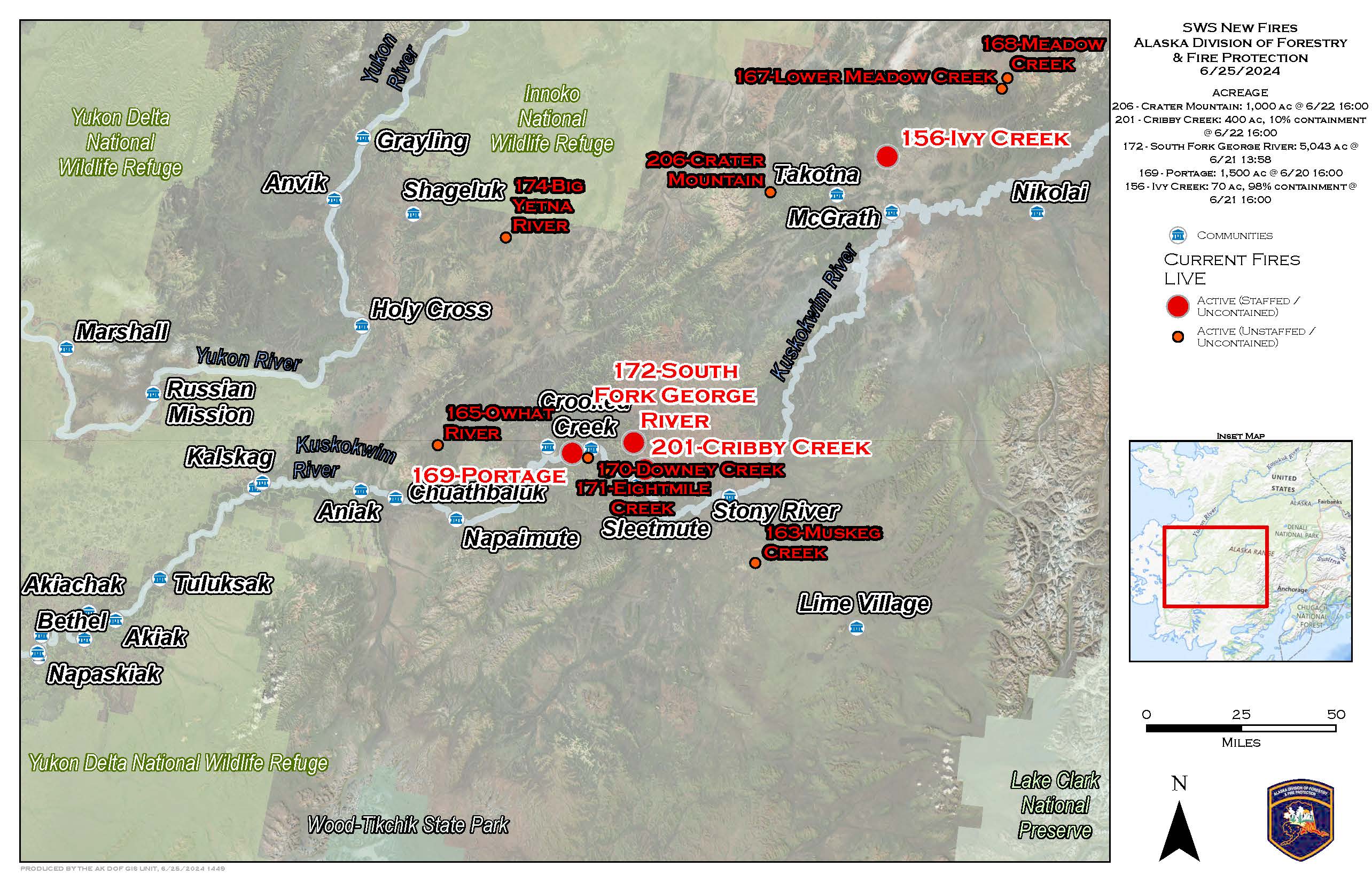
Cribby Creek Fire (#201) – 3 miles north of Red Devil is burning in a modified response area and is estimated to be 400 acres with 10% containment. 52 personnel are currently assigned. Smokejumpers gridded the fire and found no heat or visible smoke before being released and shuttled back to their base. The Laguna and Del Rosa hotshot crews from the Lower 48 were shuttled to the fire to protect Native allotments.
South Fork George River Fire (#172) – 8.5 miles northeast of Georgetown in a modified response area and is estimated to be 7,219 acres, a reduction in acres after satellite mapping. Chena Hotshots are assessing Native allotments and starting protection measures. Satellite monitoring shows new heat signatures on both the east and west sides of the fire.
Portage Fire (#169) – 5.5 miles southwest of Georgetown, south of the Kuskokwim River, in a full response area and is estimated to be 1,500 acres. 19 personnel assigned. The U.S. Forest Service R-10 T2IA crew continues to construct an indirect fireline to protect allotments to the northeast of the fire. They will look for opportunities to go direct on the fire’s edge to stop its spread.
Additional staffed fires in Southwest Alaska are listed below with Tuesday updates to suppression efforts, personnel, and acreage.
Ivy Creek Fire (#156) – 14.5 miles north of McGrath in a modified response area and is estimated to be 70 acres with 98% containment. 20 personnel assigned. Alaska Division of Forestry & Fire Protection firefighters have completed mopping-up an area to 100 feet wide into the burned area along the fire’s perimeter. They will conduct a final grid Wednesday and prepare for backhaul of equipment, supplies and trash for an anticipated demobilization Thursday.
There are 26 additional fires burning in limited management areas that will continue to be monitored by the Southwest Area DOF office. The Division of Forestry & Fire Protection will continue to share information about the fires in Southwest Alaska as it becomes available from reconnaissance flights and ground resources.
For more information on fire response management options in Alaska, visit https://forestry.alaska.gov/fire/fireplans.
For more information on active fires in Alaska, read the daily Alaska Interagency Coordination Center Situation Report found online here, https://fire.ak.blm.gov/content/aicc/sitreport/AICC%20Situation%20Report.pdf

Categories: Active Wildland Fire, Alaska DNR - Division of Forestry (DOF)
