Firefighters are making solid progress on five staffed fires in Southwest Alaska. While ground resources work in conjunction with aerial support to push containment percentages up on staffed fires, several other unstaffed fires continue to grow. The decision whether or not to staff a fire is based largely on proximity to values at risk and which fire management option the fire is in. Action is more frequently taken on a fire in critical or full protection areas as opposed to a fire in modified or limited protection areas. Firefighters are diligently working to control as many of the fires as possible to stay ahead of anticipated new starts after Thursday’s lightning.
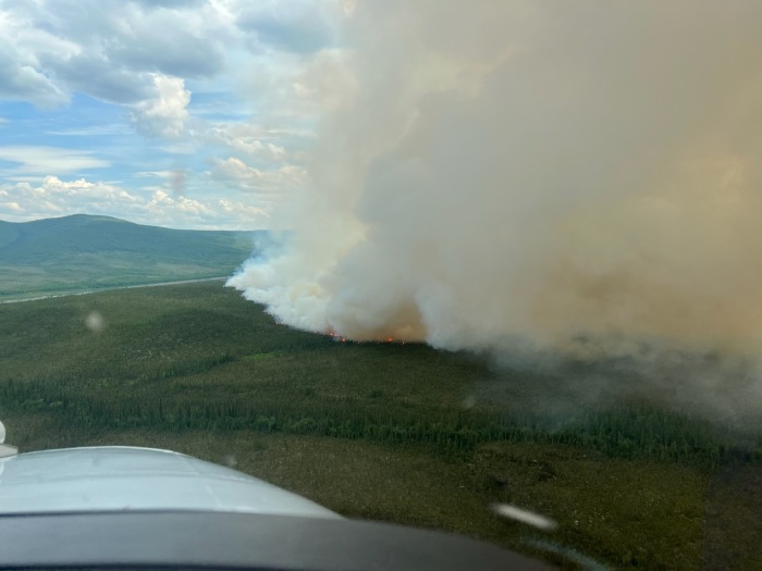
Thursday, Alaska saw almost 2,000 lightning strikes statewide and Southwest Alaska got it’s share. Most of the lightning was accompanied by varying amounts of precipitation. Fire managers have ordered aircraft to fly detection routes, looking for new starts that were sheltered enough to endure the rain from storms. As firefighters work on wrapping up current fires, which also received varying amounts of rain, they are prepared to take action on any new starts which may pose a threat to lives or property.
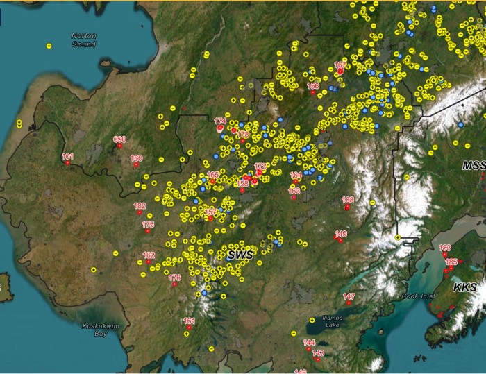
Below is an update of action taken Thursday on fires in Southwest Alaska. Personnel assigned and acreages have been updated to reflect the most recent numbers.
The Mishevik Slough Fire (#175) size has been corrected to 67.4 acres due to more accurate mapping. Eight smokejumpers mopped up and thoroughly checked the fire for any remaining heat. No smoke or heat was found. The fire is now 100% contained and controlled. All eight personnel will demobilize from the fire Friday and head back to McGrath. There are multiple allotments and structures nearby. This fire plots in a full suppression management area. This fire will be moved to monitor status.
The Flat Creek Fire (#178) was worked on the west end by 15 personnel to bring the containment of the 36-acre fire up to 60%. Moderate to heavy precipitation moved over the fire in the evening. Mining structures and the airstrip in the Flat area are protection priorities. This fire is burning in a full suppression management area.
The Ivy Creek Fire (#156) is now staffed by a total of 15 firefighters. Fire personnel worked along the right side of the fire to extinguish areas of heat and continued to mop-up. Firefighters are working to put out all heat within 100’ of the fire’s perimeter. The fire is 69.8 acres and 90% contained. This fire is burning in a modified suppression management area. The nearest cabin is 5 miles away.
The Big Yetna Fire (#174) saw significant fire growth over the last couple of days and is currently at 3,500 acres. The fire has moved to within 2 miles of an Iditarod Trail safety cabin. A Helitack crew of 5 was delivered to the fire to protect and make improvements around the cabin. Firefighters are projecting completion of their objectives by mid-day on Friday.
The Meadow Creek Fire (#168) & Lower Meadow Creek Fire (#167) have merged into one fire due to growth. The combined size is estimated to be 4,000. Aerial observation platforms were unable to fly the fire due to dense smoke in the area. There is a Native allotment as well as cabins and a radio repeater site within 5 miles. This fire is burning in a limited protection management area. DOF is monitoring this fire and action will be taken if needed.
These fires are under Type 3 Incident Command:
The Portage Fire (#169) has grown to 1,500 acres and is burning in grass and tundra. Retardant was dropped on the east side flank and the fire is moving into an old, burned area on the west side. 12 smokejumpers along with two retardant tankers worked the fire Thursday. Native allotments near the fire are protection priorities. Hand crews as well as pump and hose equipment are on order to be delivered to the fire. This is a full suppression fire, and multiple allotments are in the surrounding area.
The Eightmile Creek Fire (#171) is currently estimated to be 2,500 acres and growing, burning in black spruce and mixed hardwoods. The fire is slowly spreading to the east. This fire is burning in a full suppression management area, 2.5 miles south of an allotment and 8.5 miles west of Red Devil. The Kuskokwim River is acting as a natural barrier to fire spread between the fire and allotment. No values are immediately threatened and there is no current threat to Red Devil.
The South Fork George River Fire (#172) has been updated to 6,000 acres in size. This fire is burning in a modified suppression management area near several Native allotments. DOF is coordinating with newly arriving resources and developing a response plan.
The Muskeg Creek Fire (#163) acreage has increased to 247 acres due to recent mapping. The fire is still 3 miles to the west of Stoney River Lodge. Some visible smoke was observed. This fire is burning in a modified suppression management area, there is a body of water and wetlands between the lodge and the fire. DOF will continue to monitor this fire and respond as needed.
The Owhat River Fire (#165) was reported by residents of Chuathbaluk. The fire is 700 acres and has been placed in monitor status. This fire is burning in a modified suppression management area. There are no values at risk. DOF will continue to monitor this fire and respond as needed.
The Downey Creek Fire (#170) is currently at 50 acres and smoldering with light smoke visible. This fire is burning in a modified suppression management area, 2.5 miles to the south of Georgetown. No values are immediately threatened.
There are 13 additional fires burning in limited management areas that will continue to be monitored by the Southwest Area DOF office. The Division of Forestry & Fire Protection will continue to share information about the fires in Southwest Alaska as it becomes available from reconnaissance flights and ground resources.
For more information on fire management options in Alaska, visit https://forestry.alaska.gov/fire/fireplans.
Categories: AK Fire Info
