Nenana Ridge Complex Update
Aug. 7, 2025
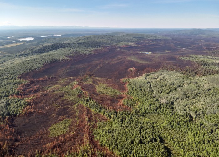
Bonanza Creek Fire (#238): 12,576- acres, 22% containment
Goldstream Creek Fire (#270): 20,471 acres, 47% containment
Personnel: 58
It is important that the public knows that the forest roads in the Nenana Ridge Complex have restricted access. Only fire personnel will be allowed access to these areas due to ongoing fire activities. The following roads and any connecting roads fall under this road restriction; Nenana Ridge Road, Bonanza Creek Road, Maisch Logging Road and the Skinny Dick’s logging roads. Members of the public are asked to stay out of the fire areas due to ongoing safety concerns.
Evacuation Information: All evacuation levels were downgraded Monday, July 28th by the Fairbanks North Star Borough and the Alaska Division of Homeland Security and Emergency Management to Level 1 READY. For an interactive evacuation map follow the links for 2025 Wildfire Evacuation Info on the Fairbanks North Star Borough home page, https://www.fnsb.gov/
Fire Weather: Thursday will start mostly clear with increasing cloud cover and temperatures in the mid-70s. Isolated showers will move in Thursday night and continue through the weekend as temperatures cool.
Fire Update: Unmanned Aerial Systems continue to detect areas of heat, many of which are well within the fires’ perimeters. Guided by the drone operators, the Alaska Division of Forestry & Fire Protection Fairbanks 1 Crew is digging out hot spots along the edge of the fires so that they will be exposed to the forecast rains. Digging out the areas of heat along the perimeter to catch rain will utilize the natural elements to extinguish them. If these areas were not exposed, they would continue to smolder in the deeper layers of duff where the rain would have little to no effect. Excavators continue to work in Little Goldstream community, breaking up dozer berms and rehabbing fire lines. Graders have started working on Dineege Avenue and Toghotthele Road.
No Drone Zone: Flying drones near wildfires is illegal and extremely dangerous, often leading to the grounding of firefighting aircraft and potentially causing harm to firefighters and property. A Temporary Flight Restriction (TFR) is in place over the Nenana Ridge Complex. For more information go to https://tfr.faa.gov
Parks Highway: Pilot car operations are taking place through an active construction zone unrelated to fire activities. For more information about this construction project go to: https://dot.alaska.gov/nreg/parks319to325/. For real-time road updates, visit 511.alaska.gov.
For a PDF file of this update, click here.
Public Information Line: (907) 331-0454
Email: 2025.nenanaridgecomplex@firenet.gov


Categories: Active Wildland Fire, Alaska DNR - Division of Forestry (DOF)
