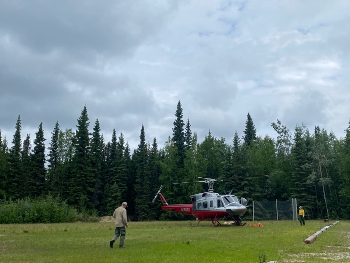
Helicopter at Harding Lake Helibase preparing for sling load missions to take point protection gear across the Tanana River. Photo by Tasha Shields, BLM AFS 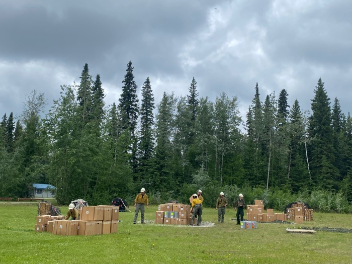
White Mountain IA crew loading sling loads to take point protection gear across the Tanana River on June 11, 2024. Photo by Tasha Shield, BLM AFS 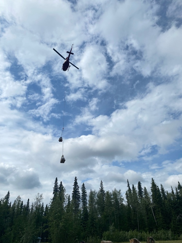
Helicopter delivering supplies to the McDonald Fire #119. June 11, 2024. Photo by Tasha Shields, BLM AFS
Rain fell on much of the McDonald Fire area Monday night, with more predicted, giving firefighters time to prepare cabin sites along 5 Mile Creek in case hot, windy, and dry conditions return.
Firefighters started clearing brush from around structures and getting sprinkler systems set in place in case the estimated 28,800-acre fire makes another push south toward the cabins. The nearest cabin is still roughly .3 mile from the fire’s edge. There were a total of 48 firefighters and support personnel assigned to the fire Tuesday morning including the BLM Alaska Fire Service Midnight Sun Hotshots, BLM AFS smokejumpers, and the Alaska Division of Forestry & Fire Protection White Mountain module. Helicopters and boats were busy shuttling the firefighters along the cabins sites as they start concentrating on structure protection.
The fire is still west of the Tanana River.
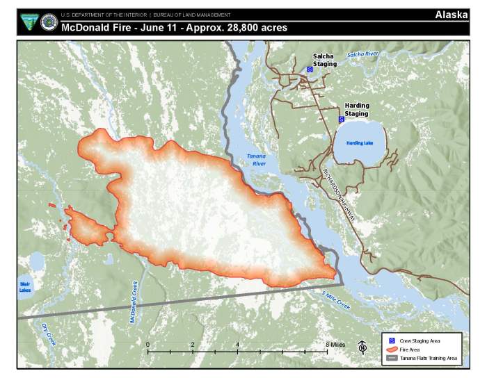
The Fairbanks North Star Borough issued a Level 2: SET level evacuation notice Tuesday afternoon for the approximately 20 cabins that near the fire’s southern edge.
To receive texted emergency alerts, create an account at Smart911. You may opt-in for direct wildfire alerts by texting “FNSBWildfireAlerts” to 67283. You can opt-out by replying “Stop.”
The borough also put areas along the lower Salcha River, Harding Lake, Hollies Acres, and Canaday neighborhoods in a Ready status. Find more information and an interactive map of these areas on the Fairbanks North Slope Borough Emergency Services website. This means people living in this area should think about what they may need to do in case of an emergency, especially if extra time is needed when preparing family members with special needs, pets or livestock. Plus, because Alaska is a fire-prone ecosystem, it’s always a good idea to put in place measures to protect your property because a wildfire could occur at any time. Adopting Firewise principles can reduce your risk of damage or loss to your property and community.

The lightning-caused fire started Saturday afternoon and quickly grew to 750 acres within three hours as 20-mph winds pushed it through black spruce. While winds subsided on Sunday, hot and dry conditions persisted that triggered more substantial growth to the east. The fire is burning through black spruce trees, which are highly flammable due to the highly resinous needles and branches that are distributed continuously from the ground to treetop that make them easy to ignite and burn. Westerly winds pushed the fire toward the Tanana River and the cabins to the south while it burned through black spruce. Both the north and south sides of the fire were actively burning on Monday, leading to another day of substantial growth.
Thankfully that won’t be the case on Tuesday, as firefighters on the ground have seen relatively little fire activity through the thick smoke.
The McDonald Fire is burning in the Tanana Flats Training Area, which is an area designated for limited management. This means that unless the fire threatens property or people, it will be allowed to play its natural ecological role. If the fire threatens a nearby site of value, land and fire managers may mobilize firefighters to protect the site without stopping the wildfire’s spread. This strategy considers firefighter safety, values at risk, and impacts on the surrounding area.
The fire reached the training area boundary on Monday, but has moved little since then.
Smoke continued to impact the communities along the Richardson Highway – especially Harding Lake and Salcha. The area will likely continue to see smoke until conditions significantly change.
Find information on how to protect yourself from wildfire smoke at https://akfireinfo.com/smoke-management/
🟡Level 2: SET – Be ready to evacuate.
- You must be prepared to leave at a moment’s notice. Bags should be packed. Level 2 signifies that there is a significant danger in your area. Load your 6P’s and 7-day kit into your vehicle.
- Relocate to a specified shelter (if activated) or with your family/friends outside of the affected area.
- Evacuate now if you need to move livestock, recreational vehicles or need extra time.
- You MAY have time to gather necessary items, but REMEMBER – you must be prepared to leave at a moment’s notice.
- If you have time, when leaving your home, write EVACUATED on a pillow case & hang it at the end of your driveway.
- THIS MAY BE THE ONLY NOTICE YOU WILL RECEIVE TO EVACUATE!
🟢Level 1 means BE READY for potential evacuate.
- Your area is prone to wildfires. Take steps now to prepare for emergencies and hazards.
- Prepare for family member(s) with special needs, mobile property (boats/trailers/ATVs) and pets or livestock.
- Monitor social media, news and radio for information.
- Emergency Personnel may contact you via an emergency notification system.
Contact BLM AFS Public Affairs Specialist Beth Ipsen at (907)356-5510, (907)388-2159 or eipsen@blm.gov for more information.
###
Bureau of Land Management, Alaska Fire Service, P.O. Box 35005 1541 Gaffney Road, Fort Wainwright, Ak 99703
Need public domain imagery to complement news coverage of the BLM Alaska Fire Service in Alaska? Visit our Flickr channel!
Learn more at www.blm.gov/AlaskaFireService, and on Facebook and Twitter.
The Bureau of Land Management Alaska Fire Service (AFS) located at Fort Wainwright, Alaska, provides wildland fire suppression services for over 240 million acres of Department of the Interior and Native Corporation Lands in Alaska. In addition, AFS has other statewide responsibilities that include: interpretation of fire management policy; oversight of the BLM Alaska Aviation program; fuels management projects; and operating and maintaining advanced communication and computer systems such as the Alaska Lightning Detection System. AFS also maintains a National Incident Support Cache with a $18.1 million inventory. The Alaska Fire Service provides wildland fire suppression services for America’s “Last Frontier” on an interagency basis with the State of Alaska Department of Natural Resources, USDA Forest Service, National Park Service, Bureau of Indian Affairs, U.S. Fish and Wildlife Service, and the U.S. Military in Alaska.
Categories: Active Wildland Fire, AK Fire Info, BLM Alaska Fire Service
