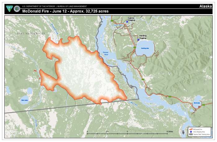
| Size: 32,725 acres | Personnel: 49 | Start Date: June 8, 2024 | Cause: Lightning |
FAIRBANKS, Alaska – The McDonald Fire received wetting rains early Wednesday morning. Similar conditions are expected throughout the day with scattered to numerous showers accompanying isolated thunderstorms in the afternoon. Winds could become gusty and erratic around the thunderstorms along with a chance for frequent lightning and some small hail. Maximum temperature of 65 degrees and minimum humidity of 46% are expected today.
Firefighters completed point protection around the nine cabins along the 5 Mile Creek in close proximity to the fire on Tuesday. This involves removing lower limbs on trees, removing brush and other vegetation and flammable items from around the buildings. Also, pumps, hoses and sprinklers are set up to wet down the structure and the surrounding area as needed. The fire is still .3 of a mile north of the nearest cabin.
Firefighters took advantage of some clearing of smoke to map the perimeter of the fire with a helicopter flight Tuesday night. This showed an increase in acreage and some changes in the perimeter. The fire remains west of the Tanana River.
Work continues Wednesday on structure protection around the cabins farther to the south. Firefighters will assess two more remote cabins farther off the creek to develop a structure protection plan.
The McDonald Fire is almost entirely burning in the Tanana Flats Training Area, which is an area designated for limited management. This means that unless the fire threatens property or people, it will be allowed to play its natural ecological role. If the fire threatens a nearby site of value, land and fire managers may mobilize firefighters to protect the site without stopping the wildfire’s spread. This strategy considers firefighter safety, values at risk, and impacts on the surrounding area.
The Alaska Division of Forestry & Fire Protection (DOF) lifted burn permit suspensions for the Tok, Delta, Fairbanks, Railbelt and Salcha Fire Protection Areas. If you choose to burn, make certain that you have a current burn permit. Click here for Burn Permits.
DOF has prepositioned resources in the Interior including some that are doing fuels mitigation work around the Harding Lake Campground.
The Alaska Department of Conservation issued an Air Quality Advisory for the Central and Eastern Alaska until 2 p.m. Tuesday due the McDonald Fire and wildfires in the Yukon Territory. Find information on how to protect yourself from wildfire smoke at the Smoke Management page on akfireinfo.com.
Evacuation notices: The Fairbanks North Star Borough (FNSB) issued a Level 2: SET evacuation notice for the approximately 20 cabins that are near the fire’s southern edge. The FNSB also put areas along the lower Salcha River, Harding Lake, Hollies Acres, and Canaday neighborhoods in a READY status. Find more information and an interactive map of these areas on the Fairbanks North Star Borough Emergency Services website.

To receive texted emergency alerts, create an account at Smart911. You may opt-in for direct wildfire alerts by texting “FNSBWildfireAlerts” to 67283. You can opt-out by replying “Stop.”
-BLM-
Bureau of Land Management, Alaska Fire Service, P.O. Box 35005 1541 Gaffney Road, Fort Wainwright, Ak 99703
Need public domain imagery to complement news coverage of the BLM Alaska Fire Service in Alaska? Visit our Flickr channel!
Learn more at www.blm.gov/AlaskaFireService, and on Facebook and Twitter.
The Bureau of Land Management Alaska Fire Service (AFS) located at Fort Wainwright, Alaska, provides wildland fire suppression services for over 240 million acres of Department of the Interior and Native Corporation Lands in Alaska. In addition, AFS has other statewide responsibilities that include: interpretation of fire management policy; oversight of the BLM Alaska Aviation program; fuels management projects; and operating and maintaining advanced communication and computer systems such as the Alaska Lightning Detection System. AFS also maintains a National Incident Support Cache with a $18.1 million inventory. The Alaska Fire Service provides wildland fire suppression services for America’s “Last Frontier” on an interagency basis with the State of Alaska Department of Natural Resources, USDA Forest Service, National Park Service, Bureau of Indian Affairs, U.S. Fish and Wildlife Service, and the U.S. Military in Alaska.
Categories: Active Wildland Fire, AK Fire Info, BLM Alaska Fire Service
