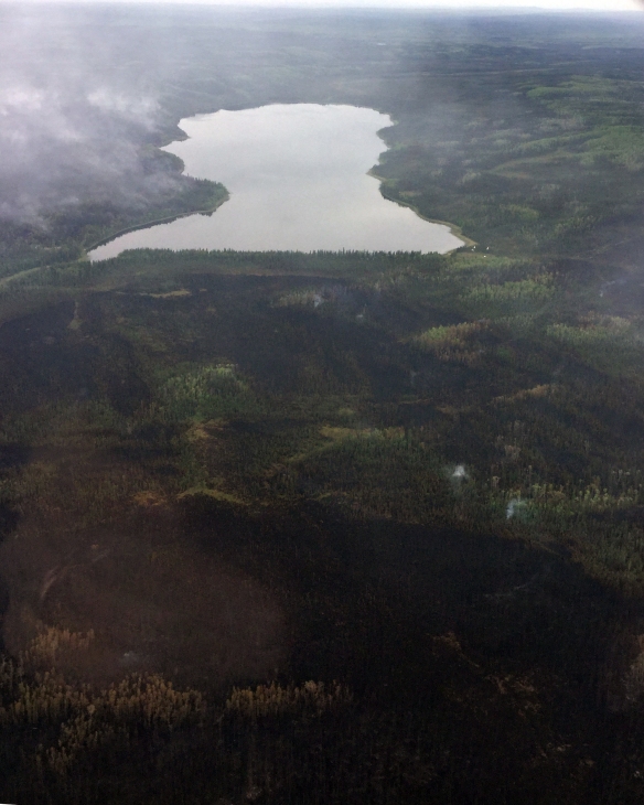
The Zitziana River Fire (#133) was smoldering on the east side (to the left) of the Kindamina Lake Saturday. Conditions moderated Saturday to allow firefighting personnel to fly over the fire and get a good look at it. Photo by Abe Davis, BLM AFS
After raining off and for 24 hours, smoke and fire activity moderated Saturday on two fires burning south of Manley Hot Springs. This gave fire personnel their first chance to get a good look at the fires since the Zitziana River Fire (#133) made a six-mile run toward the Tanana River on Wednesday. What they saw was the fire smoldering along the eastern edge of the Kindamina Lake. Strong, gusty winds pushed the Zitziana River Fire through a forest of thick, black spruce to the north and northeast edges of the Kindamina Lake by Friday. Fourteen smokejumpers, the BLM AFS Type 1 Chena Hotshots and the Type 2 IA Tanana Chiefs Crew protected numerous structures on the banks of the Kindamina Lake.
There are 136 personnel working on the fire including a Type 3 Incident Management organization set up in Manley Hot Springs to coordinate the firefighting efforts on the two fires. Eight smokejumpers and the Division of Forestry’s Type 2 Initial Attack (IA) White Mountain Crew deployed Friday to protect structures at Iksgiza Lake located six miles east of Kindamina Lake. The fire has not reached Iksgiza Lake. The original four smokejumpers that first jumped near the fire on the Tanana River to the north Thursday and the BLM AFS Midnight Sun Hotshots are busy assessing structures and Native land allotments along the Tanana River and setting up protection measures. Boats and aircraft continue to help shuttle firefighters and supplies around.
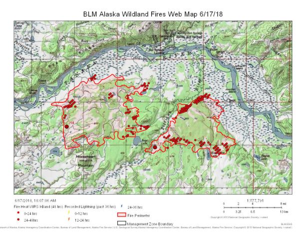
Map of Mooseheart Fire (#204), on left, and Zitziana River Fire (#133) burning south of Manley Hot Springs on June 17, 2018. Click on link 061718_133_204_AM for a PDF version of the map.
The Mooseheart Fire (#204) is estimated at 52,700 acres since it started on June 6 and the Zitziana River Fire has burned an estimated at 34,380 aces since it started on June 4. Both are lightning-caused fires burning in a limited fire management option area that allows fires to function in their normal ecological role while allowing protection for structures and Native allotments at risk.
A temporary flight restriction (TFR) was put in place Friday and expanded Saturday to provide a safe flying area for the multitude of aircraft working in support with firefighters on the ground. Airmen are asked to regularly check NoTAMs as the TFR area may expand along with firefighting efforts. For more information regarding NoTAM Number FDC 8/6507, go to http://tfr.faa.gov/save_pages/detail_8_6507.html
For more information, contact BLM AFS Public Affairs Specialist Beth Ipsen at (907)356-5510 or eipsen@blm.gov.
###
Categories: AK Fire Info
