Start Date: 06/05/2020
Location: 17 miles SW of Stevens Village, AK
Cause: Lightning
Fire Size: 12,180 acres
Containment: 69%
Total Personnel: 164
(FAIRBANKS, Alaska) – An infrared (IR) detection flight this morning showed two pockets of heat on the uncontained east side of the Isom Creek Fire. Due to the steep hillsides and the amount of blown down and jack-strawed trees, fire managers will determine if firefighters can safely attack these interior pockets of heat or if they will be monitored. IR flights will continue this week.
Due to rain over the weekend, cloud cover and forecast precipitation, the fire is not expected to spread in the near future. Firefighters have not seen active fire or smoke over the past two days. Because smoldering hot spots can grow into larger fires again if extreme conditions return, firefighters are maintaining a presence on the Isom Creek Fire (#187) at this time despite low fire activity. Fire management downgraded from a Type 2 team to a Type 3 organization Monday.
Crews are actively looking for hot spots and conducting suppression repair. Segments of the firelines have been identified to build water bars to prevent erosion, and some access points to firelines are being blocked to prevent erosion and overuse in the future. Resource advisors, who work with fire managers to convey concerns about natural, cultural and wilderness resources, will inspect repair efforts today and later this week.
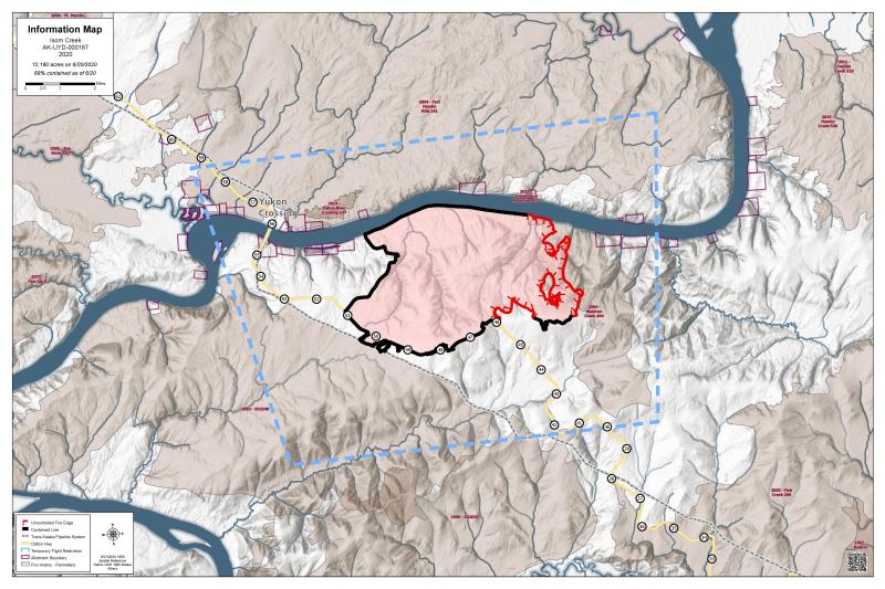
The eastern edge of the fire is not yet secured but no fire spread is expected in the next few days. The edge is extremely ragged where the fire burned on very steep terrain. As an example, a crew measured eight miles of fire perimeter within a one-square-mile section. Last week firefighters prepared for a burnout to secure the eastern edge of the fire, but could not conduct it due to rain. Equipment is in place so the burnout can be ignited if extreme fire conditions return.
The southern and western edges of the fire are contained along the Dalton Highway, Trans-Alaska Pipeline and the Hovercraft Road to the Yukon River. Crews mopped up and gridded 300 feet into the fire from the perimeter on the western and southern boundaries. The northern edge of the fire is contained by the Yukon River. Native allotments and structures in the river corridor are secured and mopped up.
The Dalton Highway remains open to travel, with traffic control as needed for smoke conditions or in support of firefighting efforts. The Five Mile Campground near the Yukon Bridge on the Dalton Highway remains closed to public access; it is reserved for crews fighting the Isom Creek Fire. The Yukon River Camp north of the Yukon River Bridge at milepost 56 is open for food, fuel and lodging.
The fire reached the Trans-Alaska Pipeline; however, it is not damaged as it was designed to withstand wildfires.
A Temporary Flight Restriction (TFR) remains in place over the fire and some of the surrounding area to provide a safe operating environment for firefighting aircraft.
The Isom Creek Fire was started by lightning on June 5 and is burning south of the Yukon River east of the Dalton Highway.
For more information about the fire, call the Alaska Interagency Fire Information Office at (907)356-5511, email 2020.isomcreek@firenet.gov or go to http://www.facebook.com/BLMAFS/
For a pdf of this report click here.
Categories: AK Fire Info
