Start Date: 06/05/2020
Location: 17 miles SW of Stevens Village, AK
Cause: Lightning
Fire Size: 12,180 acres
Containment: 69%
Total Personnel: 151
(FAIRBANKS, Alaska) – Activity continues to ramp down on the Isom Creek Fire with some firefighters taking care of one of the remaining pockets of heat within the fire perimeter while others undertaking suppression repair. On Tuesday, the BLM Alaska Fire Service Chena Hotshots discovered a pocket of heat smoldering under a log that protected it from rain and extinguished it. An infrared (IR) detecting aircraft flew over the entire fire on Tuesday and revealed one other hot spot on the northeastern side of the fire smoldering in a very steep and difficult to access area. Although the spot currently has a very low threat of expanding due to weather and terrain, fire managers are monitoring it because history has shown that hot spots smoldering in damp weather can erupt into large-scale fires if extreme conditions return. Drones equipped with IR cameras will fly the fire looking for hot spots later this week.
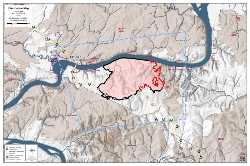
Meanwhile, fire crews are undertaking suppression repair on the northwest boundary of the fire between the Yukon River and Hovercraft Road. Trees and brush that were cut and removed along an indirect fireline in preparation for a burn out are being moved back onto the line to return it to a more natural state. Because firefighter safety is the highest priority, crews are being careful as roads and trails are becoming slick from light rain. Fire crews are also removing debris from the incident and previous visitors at the Five Mile camp to keep it clean and safe for future campers.
Skies over the fire were 100% overcast this morning with rain and isolated thundershowers in the forecast. There is little chance for fuels to dry and the fire is not expected to spread. The BLM AFS Type 3 management team plans to downgrade to a Type 4 organization by early next week. Non-essential equipment is being pulled from the field while several resources plan to demobilize tomorrow.
The eastern edge of the fire remains uncontrolled but preparations for a burnout to secure that line have been made if extreme burning conditions return. Equipment placed to protect structures on allotments along the Yukon River will remain in place.
The Dalton Highway remains open to travel, with traffic control as needed for smoke conditions or in support of firefighting efforts. The Five Mile Campground near the Yukon Bridge on the Dalton Highway remains closed to public access; it is reserved for crews fighting the Isom Creek Fire. The Yukon River Camp north of the Yukon River Bridge at milepost 56 is open for food, fuel and lodging. The fire reached the Trans-Alaska Pipeline; however, it is not damaged as it was designed to withstand wildfires.
A Temporary Flight Restriction (TFR) remains in place over the fire and some of the surrounding area to provide a safe operating environment for firefighting aircraft.
The Isom Creek Fire was started by lightning on June 5 and is south of the Yukon River east of the Dalton Highway.
For more information, contact the Alaska Interagency Fire Information Office at (907) 356-5511. For a pdf of this report click here.
Categories: AK Fire Info
