Yesterday June 18, the year-to-date number of acres burned by wildfires in
Alaska reached 1,005,196. This is the earliest date for reaching a million
acres since this statistic was first tracked in 1990.
Widespread thunderstorms and lightning are causing several new fires each day. 2,800 lightning strikes were recorded state-wide yesterday. Although this week’s thunderstorms have been mostly wet, rainfall is spotty, and vegetation is dry and conducive to ignition. A warming and drying trend is forecast to develop by next Tuesday or Wednesday. Fire managers expect more lightning-caused fires over each of the next several days.
As firefighters achieve their objectives and demobilize from fires that started earlier this month, other firefighters are dispatched to new fires.
The Alaska Fire Service provides wildland suppression services for Department of the Interior agencies, Alaska Native Corporation lands, and military withdrawn public land under an agreement with the U.S. Army-Alaska. AFS leads the BLM Alaska’s statewide Fire and Aviation program. AFS-protected lands primarily lie in the
Interior north of the Alaska Range.
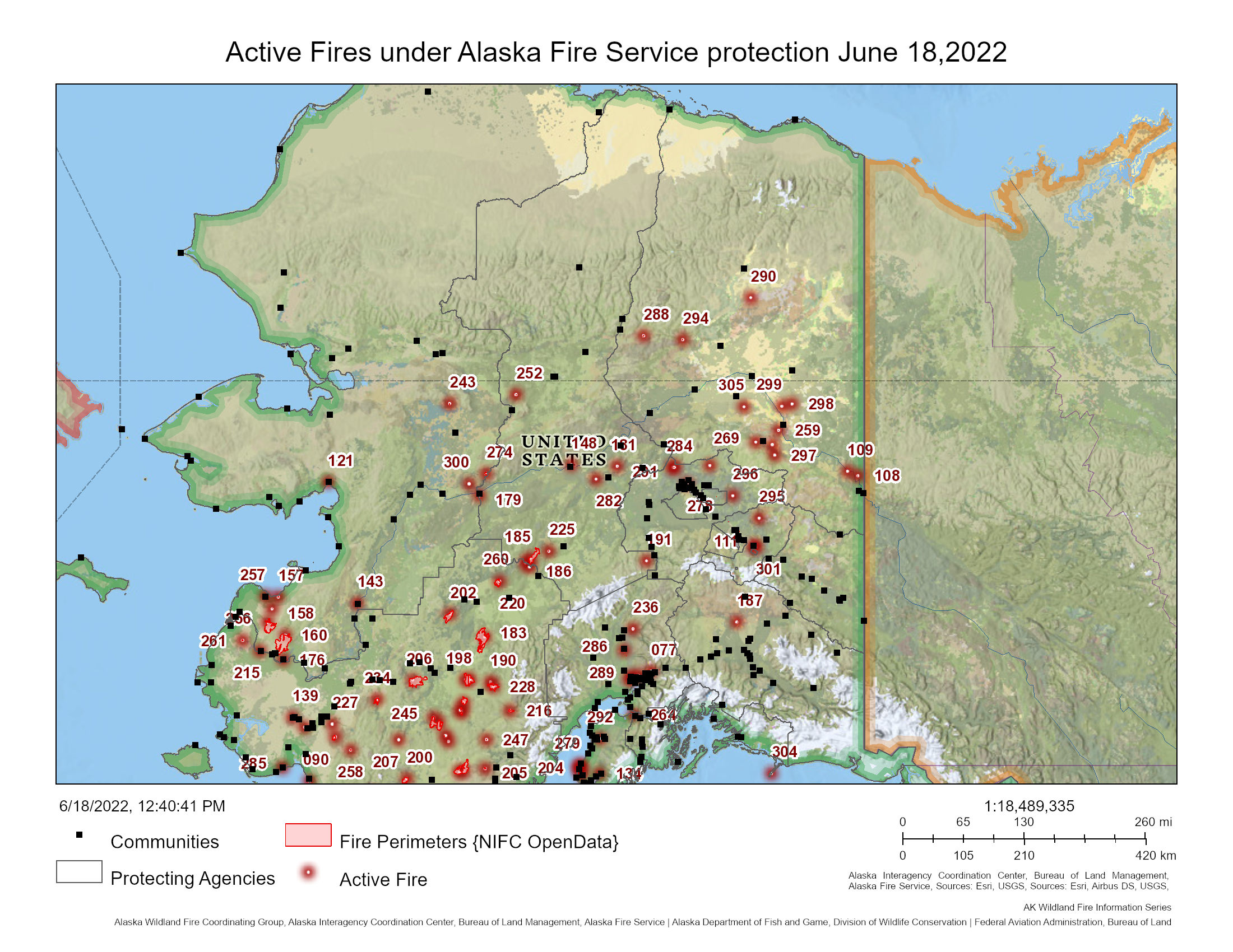
Here is an overview of the most noteworthy active fires under AFS protection, as of June 18 at 12:00 p.m.:
Upper Yukon Zone:
On June 17 five new fires were discovered:
The Schilling Fire (#294) is burning in a limited protection area 38 miles west of Venetie. As of last evening, the fire was estimated at 200 acres. Fire personnel will monitor the fire via aircraft as weather allows.
The Birch Creek Fire (#297) is 20 miles southeast of Central. It is creeping and smoldering inside an old burn in a limited protection area. Two smokejumpers were deployed last night to suppress the fire.
The Big Fire (#298) is 24 miles northeast of Circle. It is creeping and backing, with some open flames observed in hardwoods. The fire is approximately 5 acres and is a limited fire. It will be monitored by air as weather conditions allow.
The Approximate Fire (#299) is 20 miles north of Circle and is in a modified protection area. The fire is less than an acre in size. Members of the Entiat Hotshot Crew worked the fire yesterday assisted by helicopter water bucket drops. This suppression work is continuing today.
The Medicine Fire (#302) was detected last night smoldering in tussock tundra in a valley bottom about 4 miles east of Circle Hot Springs. Today, members of the Entiat Hotshot Crew are working to suppress the fire with assistance from a light helicopter.
Other Fires:
The Bolgen Creek Fire (#259) is a 17-acre fire near milepost 152 on the Steese Highway in a full protection area. Today personnel are pulling fire hose and water handling equipment and plan to demobilize all personnel on Sunday.
The Boatman Fire (#288) is burning in tundra and grass in a limited protection area 20 miles east of Coldfoot. It was estimated at 200 acres last evening. The fire is being monitored by air as weather conditions allow.
The Winter Trail Fire (#290) is about 30 miles south of Arctic Village in full protection. It is 2.9 acres with no remaining smoke or hot spots. All personnel plan to demobilize this evening.
Tanana Zone:
There were no new fires yesterday. Other fires:
The Hog Butte Fire (#185) is a 40,699-acre fire 28 miles west of Lake Minchumina. Today firefighters are pulling hose and water-handling equipment and plan to demobilize on Monday.
The Batztoa Lake Fire (#252) is an 88-acre fire in modified protection 16 miles north of Hughes. Areas of heat remain in pockets of spruce in the interior of the fire, but the edge of the fire is cold. 42 personnel currently are assigned. Firefighters will continue to grid the fire and extinguish hot spots.
The Bean Fire (#282) is a 1.3-acre fire 13 miles west of Manley Hot Springs in modified protection. The remaining four firefighters plan to demobilize this evening.
Galena Zone:
Yesterday one new fire was discovered:
The Bear Creek Fire (#300) is 30 miles northeast of Galena in a limited protection area. Last evening the fire was estimated at 15 acres burning in black spruce toward the west. The fire is being monitored via aircraft as weather conditions allow.
Other fires:
The East Fork Fire (#160) just north of St. Mary’s. Public Information Officers assigned to this fire are regularly posting updates. Please refer to those posts for the most current information.
The Melozitna Fire (#274) is approximately 19 miles northeast of Ruby and is 2,247 acres. The fire is a limited fire with 6 firefighters assigned. Firefighters are doing structure protection and anticipate demobilizing on Monday or Tuesday.

For more information, please contact Alaska Fire Information at 907-356-5511.
Categories: AK Fire Info
