There were eight new fires reported Thursday in State of Alaska protection jurisdiction and seven in BLM Alaska Fire Service. There are 11 staffed fires statewide. Today will be a much less active weather day overall. The main area of focus will be from the White Mountains to the Brooks Range and specifically northwest of Fort Yukon where scattered thunderstorms are expected. Most of the thunderstorms will produce a wetting rain, but there is still a chance for dry thunderstorms across the Interior, especially in the Yukon Flats. With high temperatures and windy conditions, the western Yukon Flats will be near red flag criteria while the South Slopes of the Eastern Brooks Range are under a Red Flag Warning from 1:00 pm until midnight. Temperatures will remain warm with the majority of the area in the 80s thorough out the area in the 80s. Burn suspensions remain in place for the Mat-Su, Valdez/Copper River, Fairbanks, Delta, and Tok areas. The suspensions will be in effect until conditions improve.
STAFFED FIRES:
Totchaket Slough Fire (#297) 15 miles north of Nenana was discovered during a detection flight and was estimated originally at 0.1 acres. Fire Bosses and helicopters were able to knock down the most active edge of the fire. Fairbanks 1 Type 2 crew was flown in to provide support. The fire is estimated at 1 acre, and Fairbanks 1 crew stayed overnight. They will continue suppression efforts throughout the day and protect values at risk in the area.
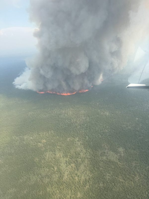
Gold King Creek Fire (#276) 45.5 miles south of Fairbanks. The fire was reported to be 400 acres burning in black spruce, mixed hardwoods, and tundra. Aerial supervision fixed wing planes were able to coordinate tankers conducting retardant drops. The retardant proved to be effective on the anchor and the heal of the fire. Fire Bosses and Scooper planes also conducted water drops around the fire perimeter. Due to weather conditions and fire growth the initial strategy was changed from full suppression to point protection. The Yukon Type 2 crew was mobilized, and resources are assessing structures, reducing fuels, and implementing hose lays. The crew remained on the fire overnight and will stay on this fire providing suppression support.
New Fires Reported Thursday:
C Two Fire (#298) 4 miles east of Kenai Airport was reported as an escaped pile burn on private property. Kenai Fire Department was toned out for a smoke report in the area of Dogwood. Resources patrolled towards the area and arrived on scene of a 10×15 burn pile burning on the duff and no clearance with escapement into the wildland. Kenai Fire Department assisted with putting the pile out and fire was called contained and controlled at 8:00 pm on Thursday.
Kalifornsky Fire (#295) 4 miles Southeast of Kenai was reported by Alaska State Troopers as a small brush pile off the side of Kalifornsky Beach Road. DOF resources arrived on scene and discovered a 0.1 acres fire that was smoldering. The resources were able to prevent further spread. This fire will be monitored.
Even Fire (#296) 4 miles Southeast of Kenai. While Forestry resources responded to the Kalifornsky Upon arrival, Forestry resources discovered a second fire near Even Ln. The fire is 0.1 acres and resources were able to prevent any further spread. This fire will be monitored.
Bear Creek Fire (#294) 55 miles east of Eielson AFB was reported by a DOF plane. It was reported at 0.5 acres, 5 miles north of the Salcha River burning in black spruce and tundra. A DOF helicopter responded and sized up the fire at about an acre. No resources or structures are threatened. This fire will be monitored.
Sushana River Fire (#293) 24 miles west of Healy was reported as 30 acres burning in Black Spruce and mixed hardwoods. The location of the fire is about 200 ft elevation with no values at risk in the area. This fire will be monitored.

Lost Chicken Hill Fire (#291) 21 miles northeast of Tok was reported to be 200 acres. The fire can be seen near Mile 10 of the Taylor Highway. It is burning in black spruce. This fire is visible from the highway but is not threatening any resources or structures. The fire will be monitored for any changes in fire behavior or direction of travel.
Rock Creek Fire (#288) 10 miles northwest of Healy was reported by a FAA to the Division of Forestry. A plane flying over the area saw smoke near Rock Creek. The smoke report was responded to by Tri Valley Fire Department. They patrolled the area and were unable to find the location of the fire. Tri Valley will patrol the area again today to monitor for any fire activity.
Moon Lake 2 Fire (#283) 7 miles west of Tanacross was called in as a smoke report near Moon Lake. There was lightning in the area during the day, but when the smoke report was investigated, there was no fire found in the area. The area will be patrolled to monitor for any fire activity throughout the day.
Categories: Active Wildland Fire, AK Fire Info, Alaska DNR - Division of Forestry (DOF)
