
On Monday, a complex incident management team from Alaska will take command of the Grapefruit Complex of six fires burning along the Elliott Highway south of Livengood.
Most of the fires exhibited fairly significant growth under calm conditions the past couple of days. There’s a chance of cooler, moist weather moving into the area starting on either Wednesday or Thursday. While this would bring relief for those working on the fires, strong westerly winds are likely to come before the forecasted weather turns wetter and cooler. This could further push the fires, especially the Iver Fire, closer to neighborhoods along the Elliott Highway.
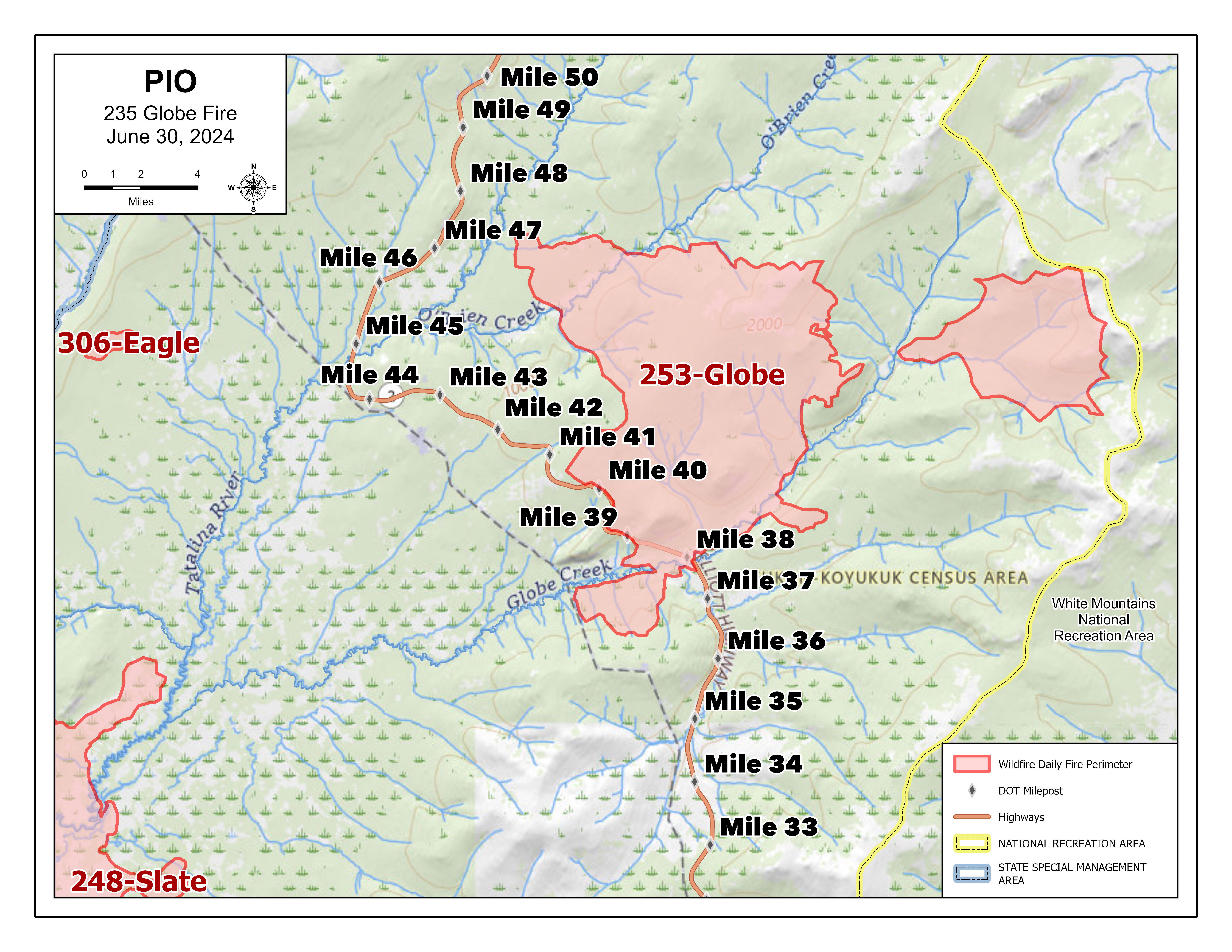
The Globe Fire (#253), which was estimated at 12,526 acres Sunday, was burning in a mostly easterly direction and farther into the White Mountains.
On Friday, the Iver and Slate fires merged into the Iver Fire (#249), now estimated at 14,649 acres and located 16 miles east of Minto. The Minto Lake stands between the fire and the community of Minto.
The Iver Fire is quickly spreading through what the fire managers described as “decadent black spruce” trees toward the Elliott Highway, and the Globe Fire. The Trans-Alaska Pipeline lies between the two fires, with the Iver Fire about 7 miles southwest of where the Globe Fire it crossed the highway at mile 39.
Crews were busy setting up sprinkler systems on structures along the Elliott Highway corridor closest to the fire Sunday. A dozer line was constructed around a small subdivision on the west side of the highway near 40 mile. A masticator – a piece of heavy equipment that uses a rotating drum with teeth or blades to grind, shred and mulch trees and brush into smaller pieces – put in a fire break around two of the three Native allotments near the fire. Firefighters will continue to brush out this line, fortify fire breaks, and set up sprinkler systems to wet down properties near the fire.
The nine-person Eagle Lake Wildland Fire Module is tasked with structure assessments for 32 miles along the Elliott Highway from mile 39.
Meanwhile, smoke continues to hamper aerial support for firefighters on the ground.
The complex also includes:
- The Eagle Fire (#306) is estimated at 118 acres. It wasn’t immediately threatening any known sites of value. This lightning-caused fire has been burning since late Friday night and has shown significant growth in the past few days.
- The Wilber Fire (#308) was fire was reported at about 2 p.m. Saturday. It is about 4 miles west of mile 51 and estimated at 77 acres.
- The Noordor Fire (#192) is estimated at 9,068 acres. This lightning-caused fire has been burning on BLM-managed land since June 20.
- The Fossil Fire (#115) is not exhibiting any fire activity or smoke, but will still be grouped into the complex. It is located in the White Mountains National Recreation Area.
Evacuation: A GO Evacuation Order is still in place for people within mileposts 39-48 of the Elliott Highway.
Road access: The section of the Elliott Highway near the Globe Fire is open. Expect significant delays between mileposts 25-50 if fire activity increases as it did Thursday afternoon. Please exercise caution and patience, turn on your headlights to help ensure the safety of firefighters and flaggers working in the area. Alaska State Troopers, Alaska Department of Transportation & Public Facilities contracted workers and a pilot car are helping keep the flow of traffic open. Check https://511.alaska.gov/ for road updates.
Temporary Flight Restriction: A TFR is in place during the day to provide a safe environment for firefighting aircraft.
Closures: The Bureau of Land Management (BLM) Eastern Interior Field Office closed the western portion of the White Mountains National Recreation Area surrounding the Wickersham Dome Trailhead at mile 28 Elliott Highway. The closure is in effect until Sept. 1, unless the BLM determines the area is safe for public use at an earlier time.
-BLM-
Bureau of Land Management, Alaska Fire Service, P.O. Box 35005, 1541 Gaffney Road, Fort Wainwright, AK 99703
Need public domain imagery to complement news coverage of the BLM Alaska Fire Service in Alaska?
Visit our Flickr channel! Learn more at www.blm.gov/AlaskaFireService, and on Facebook and Twitter.
The Bureau of Land Management Alaska Fire Service (AFS) located at Fort Wainwright, Alaska, provides wildland fire suppression services for over 240 million acres of Department of the Interior and Native Corporation Lands in Alaska. In addition, AFS has other statewide responsibilities that include: interpretation of fire management policy; oversight of the BLM Alaska Aviation program; fuels management projects; and operating and maintaining advanced communication and computer systems such as the Alaska Lightning Detection System. AFS also maintains a National Incident Support Cache with a $18.1 million inventory. The Alaska Fire Service provides wildland fire suppression services for America’s “Last Frontier” on an interagency basis with the State of Alaska Department of Natural Resources, USDA Forest Service, National Park Service, Bureau of Indian Affairs, U.S. Fish and Wildlife Service, and the U.S. Military in Alaska.
Categories: Active Wildland Fire, AK Fire Info, BLM Alaska Fire Service
