9 p.m., July 1 Update (last one for day) – After a day of hard work by aircraft and firefighters, the Riley Fire in Denali National Park and Preserve was 5% contained by Monday night. Water scoopers and helicopters doused the fire with water most of the day while 22 smokejumpers and the Tanana Chiefs Fire Crew installed hose and cut a saw line, tying it into the railroad easement to contain a section. Work will continue on Tuesday.
With the arrival of two California hotshot crews and the Chester Helitack crew, they’ll form a plan to corral the northern tip of the fire burning parallel to the railroad. They aim to keep it within the ridge on the east and the railroad on the west while increasing containment. The fire is burning in steep terrain about a mile north of the park entrance.
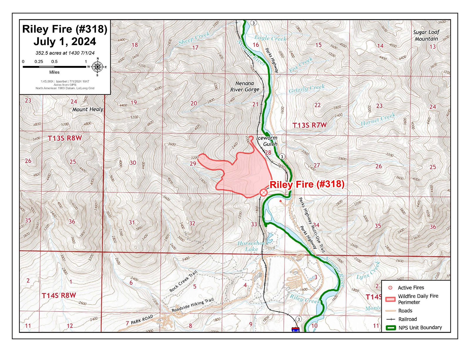
4:45 p.m., July 1 Update – Fire activity on the Riley Fire moderated Monday afternoon due to cooler, cloudy weather and water drops from aircraft slowing its growth. Firefighters estimated the fire has burned approximately 385 acres, an increase attributed to better mapping.
Helicopters, using large buckets suspended by cables from their bellies, have been especially effective, according to firefighters on the ground. These helicopters draw water from a nearby lake and navigate through the narrow canyon to make dozens of water drops. Additionally, single-engine water scoopers, known as Fire Boss airplanes, and large scoopers are cooling the fire’s edges.
Meanwhile, firefighters continue working near the fire’s edge, using hoses to deliver water and cool down the fire. They have made good progress keeping the fire away from the Denali National Park and Preserve entrance a mile south and to the west of the Nenana River. They are concentrating their efforts on the southern end and the flanks while allowing the fire to burn up a hillside where it could reach a scree slope, and stop its progression.
The Golden Eagles Hotshot Crew from the Sycuan Indian Reservation and the U.S. Forest Service Mill Creek Hotshots from California arrived in Fairbanks Monday afternoon. They will travel down the Parks Highway on Tuesday to join the suppression efforts on the Riley Fire.

The U.S. Forest Service Mill Creek Hotshots from California arrived on a jet from the Lower 48 Monday. The crew will head to the Riley Fire on Tuesday. Photo by Karin Butterfield, BLM AFS 
The Golden Eagles Hotshot Crew from the Sycuan Indian Reservation arrived on a jet from the Lower 48 Monday. The crew will head to the Riley Fire on Tuesday. Photo by Karin Butterfield, BLM AFS
1 p.m., July 1 Update – Firefighters and aircraft continue work on the Riley Fire and have kept it west of the Alaska Railroad and away from the Denali Park and Preserve entrance. The fire is still a mile north of the park entrance and on the west side of the Nenana River near mile 239 Parks Highway. No structures are immediately threatened. The Parks Highway remains open. Go to https://511.alaska.gov/ for road condition updates.
The fire is so far moving in a northwesterly direction farther into the park and away from the Nenana River Canyon, more commonly known as Glitter Gulch. This area and the park have lost power due to the wildfire.
Firefighters, aided by aircraft, hope to stop forward progress by using the railroad right of way and natural barriers – specifically a nearby ridge and alpine terrain that under most circumstances will not readily burn. Firefighters intend to use this rocky terrain to confine the fire on the north end while working more directly on the southern end to keep it away from the park entrance and west of the railroad.
The fire is burning in the highly flammable black spruce and quickly grew to 350 acres Sunday. The fire was initially described as running, spotting and torching up hill. The vegetation on the northwest end of the fire transitions into brush, which slowed down the fire’s spread. It was still estimated at 350 acres Monday morning.
Helicopters, two air tankers, four single-engine water scoopers and two larger scoopers did several rounds on the Riley Fire Sunday, dropping either water or retardant to slow the fire’s growth. This is in addition to the 22 smokejumpers and the Tanana Chiefs Fire Crew, and several federal, state and local engines supporting suppression efforts. This effort with continue with more crews expected to arrive in Fairbanks on Monday and mobilized to the fire on Tuesday.
The exact cause of the fire has yet to be established other than it’s suspected to be human caused. A fire investigator will be assigned to determine how the fire started.
The weather is expected to cool this week, accompanied with a potential for rain. However, today’s forecast predicts wind gusts of up to 30 mph. Thunderstorms are predicted in the evenings, which could bring gusty, erratic winds.
Park Closure: All visitor facilities and park operations in Denali’s entrance area will be closed Monday. Future dates will be assessed based on fire activity. The park will also continue to remain closed to personal vehicles and day use visitors until further notice. Employees evacuated from park housing are being sheltered in various facilities in the nearby town of Healy. Park officials continue to work closely with the Denali Borough and other partners to ensure everyone is taken care of. Go to the Denali National Park and Preserve website for closure information.

Evacuation notices: The Denali Borough and park have evacuation notices in place:
Red – Go: All Bison Gulch and Antler Ridge hikers and all employees housed at the Denali National Park Admin Camp, Joint Venture facility, and Riley Creek Campground: anyone in these areas should evacuate.
Yellow – Set: None at this time.
Green – Ready: Denali National Park Headquarters, Permanent Housing, C-Camp and Joint Venture Dispatch: anyone in these areas should consider the Wildfire Evacuation Checklist (found on the Riley Wildland Fire Information page on the Denali Borough website) to prepare for possible evacuation. The Nenana Canyon area (aka Glitter Gulch). Anyone in these areas should stay alert and monitor for evacuation status.
The Tri-Valley Community Center is the Evacuation Information Center at Mile 0.5 Healy Spur Road in Healy.
Temporary Flight Restriction (TFR): A Temporary Flight Restriction is in place to provide a safe environment for firefighting aircraft working on the Riley Fire.
-BLM-
Bureau of Land Management, Alaska Fire Service, P.O. Box 35005 1541 Gaffney Road, Fort Wainwright, Ak 99703
Need public domain imagery to complement news coverage of the BLM Alaska Fire Service in Alaska?
Visit our Flickr channel!
Learn more at www.blm.gov/AlaskaFireService, and on Facebook and Twitter.
The Bureau of Land Management Alaska Fire Service (AFS) located at Fort Wainwright, Alaska, provides wildland fire suppression services for over 240 million acres of Department of the Interior and Native Corporation Lands in Alaska. In addition, AFS has other statewide responsibilities that include: interpretation of fire management policy; oversight of the BLM Alaska Aviation program; fuels management projects; and operating and maintaining advanced communication and computer systems such as the Alaska Lightning Detection System. AFS also maintains a National Incident Support Cache with a $18.1 million inventory. The Alaska Fire Service provides wildland fire suppression services for America’s “Last Frontier” on an interagency basis with the State of Alaska Department of Natural Resources, USDA Forest Service, National Park Service, Bureau of Indian Affairs, U.S. Fish and Wildlife Service, and the U.S. Military in Alaska.
Categories: Active Wildland Fire, AK Fire Info, Alaska NPS, BLM Alaska Fire Service
