UPDATE 9:00 pm — The Bear Creek Fire (#237) is burning just west of the Parks Highway at Mile Post 263; the Denali Borough has issued new evacuations due to escalating fire conditions. Numerous structures are now imminently threatened so aircraft including Air Tankers and helicopters are supporting the fire with retardant and water drops.
𝗕𝗘𝗔𝗥 𝗖𝗥𝗘𝗘𝗞 𝗪𝗜𝗟𝗗𝗟𝗔𝗡𝗗 𝗙𝗜𝗥𝗘 𝗘𝗩𝗔𝗖𝗨𝗔𝗧𝗜𝗢𝗡 𝗖𝗨𝗥𝗥𝗘𝗡𝗧 𝗘𝗩𝗔𝗖𝗨𝗔𝗧𝗜𝗢𝗡 𝗦𝗧𝗔𝗧𝗨𝗦:
𝗚𝗢!
Mile 264 to 270 west of the Parks Highway
-June Creek Subdivision and Bear Creek Subdivision
-Mile 270 to Kobe Road (including all properties accessed by Kobe Road)
-Rose Hip Creek
-Kobe Ag Subdivision
-Quota Subdivision
-North Forties
-𝗦𝗘𝗧:
– Mile 262 to 264 west of the Parks Highway
**Areas in SET should prepare for possible evacuation including having a go bag ready with clothes, important documents, and emergency supplies.
𝗥𝗘𝗔𝗗𝗬:
-Mile 260 to 262 west of the Parks Highway
**Areas in READY should stay alert and monitor for evacuation status updates.
𝗧𝗵𝗲 𝗧𝗿𝗶-𝗩𝗮𝗹𝗹𝗲𝘆 𝗖𝗼𝗺𝗺𝘂𝗻𝗶𝘁𝘆 𝗖𝗲𝗻𝘁𝗲𝗿 𝗶𝘀 𝘁𝗵𝗲 𝗲𝘃𝗮𝗰𝘂𝗮𝘁𝗶𝗼𝗻 𝗰𝗵𝗲𝗰𝗸𝗽𝗼𝗶𝗻𝘁 𝘄𝗶𝘁𝗵 (𝟵𝟬𝟳) 𝟯𝟳𝟴-𝟳𝟵𝟴𝟱 𝗮𝘀 𝘁𝗵𝗲 𝗲𝘃𝗮𝗰𝘂𝗮𝘁𝗶𝗼𝗻 𝗶𝗻𝗳𝗼𝗿𝗺𝗮𝘁𝗶𝗼𝗻 𝗽𝗵𝗼𝗻𝗲 𝗻𝘂𝗺𝗯𝗲𝗿.

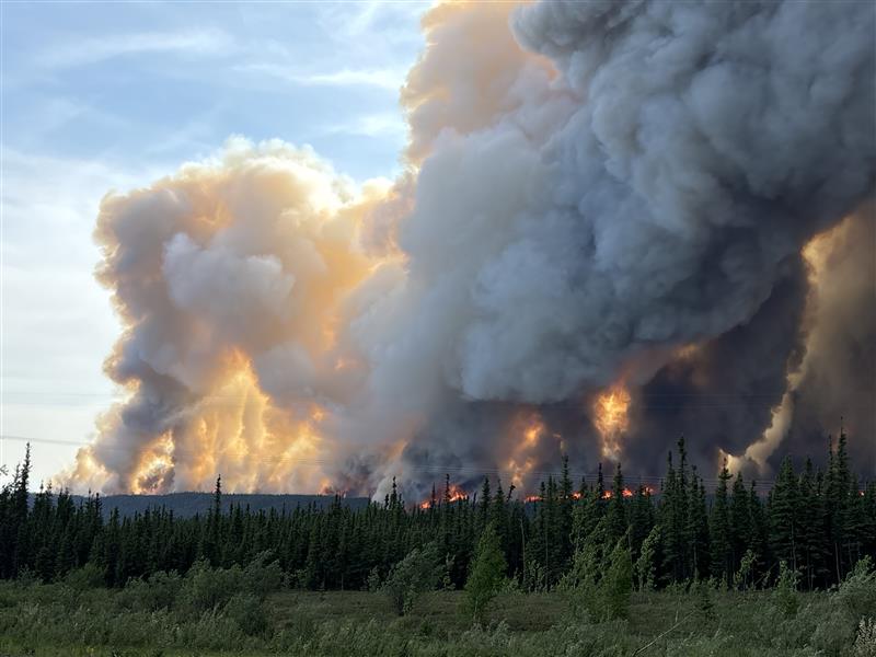
Smoke from the Bear Creek Fire bellows across the Parks Highway north of Healy, on Friday, June 20, 2025. Photo credit: Kale Casey/DOF
Trees torch on the Bear Creek Fire burning west of the Parks Highway, north of Healy on Friday June 20, 2025. Photo credit: Denali Borough
UPDATE 5:37 pm — The Bear Creek Fire (#237) is located just west of the Parks Highway at Mile Post 263; fire behavior is intensifying significantly and increasing smoke production. The Denali Borough is issuing GO status for June Creek, Washington Drive, and Bear Creek Cabins due to escalating fire conditions.
Crews and engines are working together on structure assessments, however, currently no values are imminently threatened.

For PDF file to enlarge or print click here
Air tankers are supporting smokejumpers and firefighters on the ground. McKinley Volunteer Fire Department Brush Truck, Fairbanks Area Forestry engines and helitack are responding to continue suppression efforts on the fire.
Fire managers will continue monitoring the spread of the fire via aerial heat detection satellite imagery.
As fire activity increases across the Interior, resources are prioritized and shared amongst numerous emerging incidents.
Additional information from the Denali Borough on evacuations follow their website: https://www.denaliborough.org/index.asp?SEC=%7B6947563F-9A1C-463A-BF96-D10724F39115%7D or continue reading below:

𝗖𝗨𝗥𝗥𝗘𝗡𝗧 𝗘𝗩𝗔𝗖𝗨𝗔𝗧𝗜𝗢𝗡 𝗦𝗧𝗔𝗧𝗨𝗦:
![]() 𝗚𝗢!:
𝗚𝗢!:
𝗝𝗨𝗡𝗘 𝗖𝗥𝗘𝗘𝗞 𝗦𝗨𝗕𝗗𝗜𝗩𝗜𝗦𝗜𝗢𝗡 AND 𝗕𝗘𝗔𝗥 𝗖𝗥𝗘𝗘𝗞 𝗦𝗨𝗕𝗗𝗜𝗩𝗜𝗦𝗜𝗢𝗡 (MILE 264 to 270 𝗪𝗘𝗦𝗧 OF THE PARKS HIGHWAY) ARE IN GO! EVACUATION STATUS.
AREAS IN GO! ARE ADVISED TO EVACUATE.
![]() 𝗦𝗘𝗧:
𝗦𝗘𝗧:
– 𝗠𝗜𝗟𝗘 𝟮𝟲𝟮 𝗧𝗢 𝟮𝟲𝟰 𝗪𝗘𝗦𝗧 𝗢𝗙 𝗧𝗛𝗘 𝗣𝗔𝗥𝗞𝗦 𝗛𝗜𝗚𝗛𝗪𝗔𝗬
– 𝗥𝗢𝗦𝗘 𝗛𝗜𝗣 𝗖𝗥𝗘𝗘𝗞
Areas in SET should prepare for possible evacuation including having a go bag ready with clothes, important documents, and emergency supplies.
![]() 𝗥𝗘𝗔𝗗𝗬:
𝗥𝗘𝗔𝗗𝗬:
– 𝗠𝗜𝗟𝗘 𝟮𝟲𝟬 𝗧𝗢 𝟮𝟲𝟮 𝗪𝗘𝗦𝗧 𝗢𝗙 𝗧𝗛𝗘 𝗣𝗔𝗥𝗞𝗦 𝗛𝗜𝗚𝗛𝗪𝗔𝗬
– 𝗠𝗜𝗟𝗘 𝟮𝟳𝟬 𝗧𝗢 𝗞𝗢𝗕𝗘 𝗥𝗢𝗔𝗗 (INCLUDING PROPERTIES TO THE SOUTH OF KOBE ROAD ACCESSED BY KOBE ROAD.)
Areas in READY should stay alert and monitor for evacuation status updates.
𝗧𝗵𝗲 𝗧𝗿𝗶-𝗩𝗮𝗹𝗹𝗲𝘆 𝗖𝗼𝗺𝗺𝘂𝗻𝗶𝘁𝘆 𝗖𝗲𝗻𝘁𝗲𝗿 𝗶𝘀 𝘁𝗵𝗲 𝗲𝘃𝗮𝗰𝘂𝗮𝘁𝗶𝗼𝗻 𝗰𝗵𝗲𝗰𝗸𝗽𝗼𝗶𝗻𝘁 𝘄𝗶𝘁𝗵 (𝟵𝟬𝟳) 𝟯𝟳𝟴-𝟳𝟵𝟴𝟱 𝗮𝘀 𝘁𝗵𝗲 𝗲𝘃𝗮𝗰𝘂𝗮𝘁𝗶𝗼𝗻 𝗶𝗻𝗳𝗼𝗿𝗺𝗮𝘁𝗶𝗼𝗻 𝗽𝗵𝗼𝗻𝗲 𝗻𝘂𝗺𝗯𝗲𝗿.
Categories: Active Wildland Fire, AK Fire Info, Alaska DNR - Division of Forestry (DOF)
