Update: 9:00 PM-
As of 9pm, traffic on the Parks Hwy through the Bear Creek Fire (#237) has flowed in both directions in one lane only. The pilot car may have multiple hours between the north and south routes. Expect long delays.
Update 8:00 PM – Bear Creek Fire (#237) Alaska DOT is conducting a north/south pilot car operation on the Parks Highway where it has been impacted by the Bear Creek Fire. Engines are working in the Washington Drive area and aviation continues to work the heel of the fire on the southern portion.
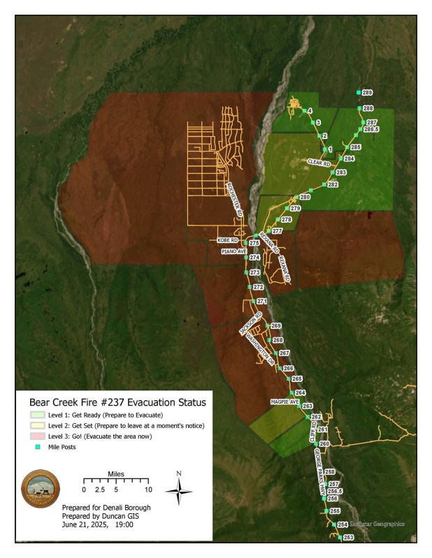
Evacuation Status has been updated by Denali Borough as follows, see attached evacuation map. 𝗠𝘂𝗹𝘁𝗶𝗽𝗹𝗲 𝗮𝗿𝗲𝗮𝘀 𝗺𝗼𝘃𝗲𝗱 𝗳𝗿𝗼𝗺 “𝗥𝗲𝗮𝗱𝘆” 𝘁𝗼 “𝗦𝗲𝘁” 𝘀𝘁𝗮𝘁𝘂𝘀.
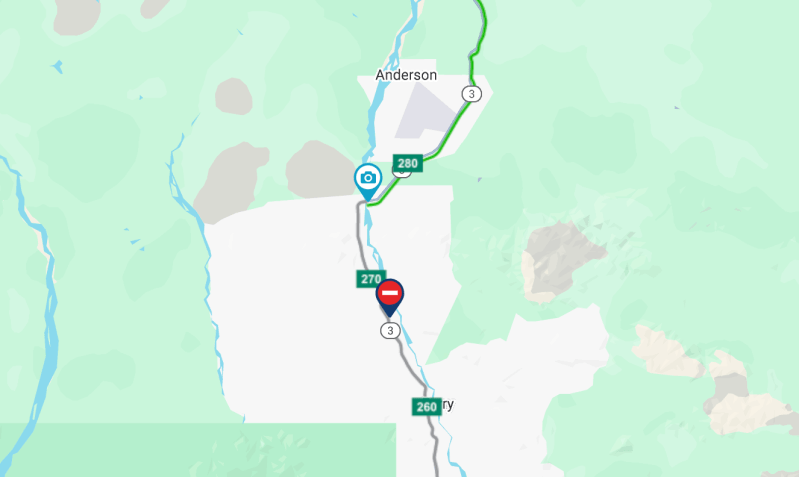
(The Parks Highway is 𝗖𝗟𝗢𝗦𝗘𝗗 check https://511.alaska.gov/ Traveler Information for real time highway information.)
𝗖𝗨𝗥𝗥𝗘𝗡𝗧 𝗘𝗩𝗔𝗖𝗨𝗔𝗧𝗜𝗢𝗡 𝗦𝗧𝗔𝗧𝗨𝗦:
🔴 𝗚𝗢!:
- 𝗝𝗨𝗡𝗘 𝗖𝗥𝗘𝗘𝗞 𝗦𝗨𝗕𝗗𝗜𝗩𝗜𝗦𝗜𝗢𝗡 AND 𝗕𝗘𝗔𝗥 𝗖𝗥𝗘𝗘𝗞 𝗦𝗨𝗕𝗗𝗜𝗩𝗜𝗦𝗜𝗢𝗡 (MILE 264 to 270 𝗪𝗘𝗦𝗧 OF THE PARKS HIGHWAY)
- 𝗠𝗜𝗟𝗘𝗣𝗢𝗦𝗧 𝟮𝟲𝟰 𝗧𝗢 𝗥𝗘𝗫 𝗕𝗥𝗜𝗗𝗚𝗘 𝗘𝗔𝗦𝗧 𝗢𝗙 𝗧𝗛𝗘 𝗛𝗜𝗚𝗛𝗪𝗔𝗬 𝗔𝗡𝗗 𝗪𝗘𝗦𝗧 𝗢𝗙 𝗧𝗛𝗘 𝗡𝗘𝗡𝗔𝗡𝗔 𝗥𝗜𝗩𝗘𝗥
- 𝗠𝗜𝗟𝗘𝗣𝗢𝗦𝗧 𝟮𝟳𝟬 𝗧𝗢 𝗥𝗘𝗫 (𝗝𝗔𝗖𝗞 𝗖𝗢𝗚𝗛𝗜𝗟𝗟 𝗠𝗘𝗠𝗢𝗥𝗜𝗔𝗟) 𝗕𝗥𝗜𝗗𝗚𝗘 (INCLUDING ALL PROPERTIES ACCESSED BY KOBE ROAD)
- 𝗥𝗢𝗦𝗘 𝗛𝗜𝗣 𝗖𝗥𝗘𝗘𝗞
- 𝗞𝗢𝗕𝗘 𝗔𝗚 𝗦𝗨𝗕𝗗𝗜𝗩𝗜𝗦𝗜𝗢𝗡
- 𝗤𝗨𝗢𝗧𝗔 𝗦𝗨𝗕𝗗𝗜𝗩𝗜𝗦𝗜𝗢𝗡
- 𝗡𝗢𝗥𝗧𝗛 𝗙𝗢𝗥𝗧𝗜𝗘𝗦
AREAS IN GO! ARE ADVISED TO EVACUATE.
The Tri-Valley Community Center is the evacuation checkpoint with (907) 378-7985 as the evacuation information phone number.
🟡 𝗦𝗘𝗧: - 𝗠𝗜𝗟𝗘 𝟮𝟲𝟮 𝗧𝗢 𝟮𝟲𝟰 𝗪𝗘𝗦𝗧 𝗢𝗙 𝗧𝗛𝗘 𝗣𝗔𝗥𝗞𝗦 𝗛𝗜𝗚𝗛𝗪𝗔𝗬
- 𝗣𝗥𝗢𝗣𝗘𝗥𝗧𝗜𝗘𝗦 𝗔𝗖𝗖𝗘𝗦𝗦𝗘𝗗 𝗘𝗔𝗦𝗧 𝗢𝗙 𝗧𝗛𝗘 𝗣𝗔𝗥𝗞𝗦 𝗛𝗜𝗚𝗛𝗪𝗔𝗬 𝗙𝗥𝗢𝗠 𝗧𝗛𝗘 𝗥𝗘𝗫 (𝗝𝗔𝗖𝗞 𝗖𝗢𝗚𝗛𝗜𝗟𝗟 𝗠𝗘𝗠𝗢𝗥𝗜𝗔𝗟) 𝗕𝗥𝗜𝗗𝗚𝗘 𝗧𝗢 𝗠𝗜𝗟𝗘𝗣𝗢𝗦𝗧 𝟮𝟳𝟳
- 𝗣𝗥𝗢𝗣𝗘𝗥𝗧𝗜𝗘𝗦 𝗔𝗖𝗖𝗘𝗦𝗦𝗘𝗗 𝗩𝗜𝗔 𝗧𝗛𝗘 𝗥𝗘𝗫 𝗧𝗥𝗔𝗜𝗟 𝗔𝗡𝗗 𝗦𝗨𝗥𝗥𝗢𝗨𝗡𝗗𝗜𝗡𝗚 𝗔𝗥𝗘𝗔
- 𝗣𝗥𝗢𝗣𝗘𝗥𝗧𝗜𝗘𝗦 𝗔𝗖𝗖𝗘𝗦𝗦𝗘𝗗 𝗘𝗔𝗦𝗧 𝗢𝗙 𝗧𝗛𝗘 𝗣𝗔𝗥𝗞𝗦 𝗛𝗜𝗚𝗛𝗪𝗔𝗬 𝗙𝗥𝗢𝗠 𝗠𝗜𝗟𝗘𝗣𝗢𝗦𝗧 𝟮𝟳𝟳-𝟮𝟴𝟬
- 𝗣𝗥𝗢𝗣𝗘𝗥𝗧𝗜𝗘𝗦 𝗔𝗖𝗖𝗘𝗦𝗦𝗘𝗗 𝗪𝗘𝗦𝗧 𝗢𝗙 𝗧𝗛𝗘 𝗣𝗔𝗥𝗞𝗦 𝗛𝗜𝗚𝗛𝗪𝗔𝗬 𝗙𝗥𝗢𝗠 𝗥𝗘𝗫 (𝗝𝗔𝗖𝗞 𝗖𝗢𝗚𝗛𝗜𝗟𝗟 𝗠𝗘𝗠𝗢𝗥𝗜𝗔𝗟) 𝗕𝗥𝗜𝗗𝗚𝗘 𝗧𝗢 𝗠𝗜𝗟𝗘𝗣𝗢𝗦𝗧 𝟮𝟴𝟬
- 𝗖𝗟𝗘𝗔𝗥 𝗦𝗣𝗔𝗖𝗘 𝗙𝗢𝗥𝗖𝗘 𝗦𝗧𝗔𝗧𝗜𝗢𝗡
Areas in SET should prepare for possible evacuation including having a go bag ready with clothes, important documents, and emergency supplies.
🟢 𝗥𝗘𝗔𝗗𝗬: - 𝗠𝗜𝗟𝗘 𝟮𝟲𝟬 𝗧𝗢 𝟮𝟲𝟮 𝗪𝗘𝗦𝗧 𝗢𝗙 𝗧𝗛𝗘 𝗣𝗔𝗥𝗞𝗦 𝗛𝗜𝗚𝗛𝗪𝗔𝗬
- 𝗠𝗜𝗟𝗘𝗣𝗢𝗦𝗧 𝟮𝟲𝟬-𝟮𝟲𝟰 𝗘𝗔𝗦𝗧 𝗢𝗙 𝗧𝗛𝗘 𝗛𝗜𝗚𝗛𝗪𝗔𝗬 𝗔𝗡𝗗 𝗪𝗘𝗦𝗧 𝗢𝗙 𝗧𝗛𝗘 𝗡𝗘𝗡𝗔𝗡𝗔 𝗥𝗜𝗩𝗘𝗥
- 𝗖𝗜𝗧𝗬 𝗢𝗙 𝗔𝗡𝗗𝗘𝗥𝗦𝗢𝗡 𝗔𝗡𝗗 𝗦𝗨𝗥𝗥𝗢𝗨𝗡𝗗𝗜𝗡𝗚 𝗔𝗥𝗘𝗔
Areas in READY should stay alert and monitor for evacuation status updates.
𝗧𝗵𝗲 𝗧𝗿𝗶-𝗩𝗮𝗹𝗹𝗲𝘆 𝗖𝗼𝗺𝗺𝘂𝗻𝗶𝘁𝘆 𝗖𝗲𝗻𝘁𝗲𝗿 𝗶𝘀 𝘁𝗵𝗲 𝗲𝘃𝗮𝗰𝘂𝗮𝘁𝗶𝗼𝗻 𝗰𝗵𝗲𝗰𝗸𝗽𝗼𝗶𝗻𝘁 𝘄𝗶𝘁𝗵 (𝟵𝟬𝟳) 𝟯𝟳𝟴-𝟳𝟵𝟴𝟱 𝗮𝘀 𝘁𝗵𝗲 𝗳𝗶𝗿𝗲 𝗮𝗻𝗱 𝗲𝘃𝗮𝗰𝘂𝗮𝘁𝗶𝗼𝗻 𝗶𝗻𝗳𝗼𝗿𝗺𝗮𝘁𝗶𝗼𝗻 𝗽𝗵𝗼𝗻𝗲 𝗻𝘂𝗺𝗯𝗲𝗿

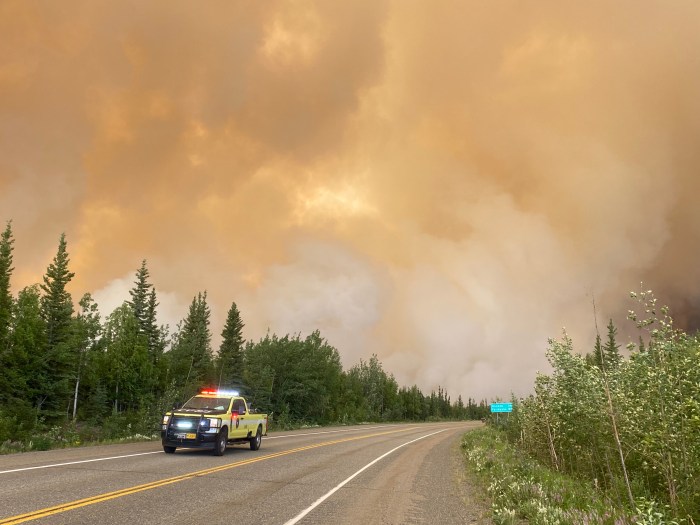
UPDATE 16:00 — The Bear Creek Fire (#237) has progressed across the Parks Highway between Mile Post 270-274; new evacuations levels are in effect due to escalating fire conditions. Air resources, including tankers and scooper planes, coordinated by air attack, continue to assist crews, engines and heavy equipment on the ground in suppression efforts.
Please drive with extreme caution and expect delays in fire areas. Law enforcement is working with firefighters and the DOT to coordinate safe travel in this area. Fire crews will be working in close proximity to roadways, smoke will affect visibility. Reduce speeds and give firefighting apparatus room to work.
Alaska DOT has temporarily closed Parks Highway both directions from mile marker 267 to mile marker 278. Check https://511.alaska.gov/ for traveler Information and real time highway information and road closures.
The Denali Borough has updated evacuation levels for this fire based on current conditions.
𝗖𝗨𝗥𝗥𝗘𝗡𝗧 𝗘𝗩𝗔𝗖𝗨𝗔𝗧𝗜𝗢𝗡 𝗦𝗧𝗔𝗧𝗨𝗦:
🔴 𝗚𝗢!:
– 𝗝𝗨𝗡𝗘 𝗖𝗥𝗘𝗘𝗞 𝗦𝗨𝗕𝗗𝗜𝗩𝗜𝗦𝗜𝗢𝗡 AND 𝗕𝗘𝗔𝗥 𝗖𝗥𝗘𝗘𝗞 𝗦𝗨𝗕𝗗𝗜𝗩𝗜𝗦𝗜𝗢𝗡 (MILE 264 to 270 𝗪𝗘𝗦𝗧 OF THE PARKS HIGHWAY)
– 𝗠𝗜𝗟𝗘𝗣𝗢𝗦𝗧 𝟮𝟳𝟬 𝗧𝗢 𝗥𝗘𝗫 (𝗝𝗔𝗖𝗞 𝗖𝗢𝗚𝗛𝗜𝗟𝗟 𝗠𝗘𝗠𝗢𝗥𝗜𝗔𝗟) 𝗕𝗥𝗜𝗗𝗚𝗘 (INCLUDING ALL PROPERTIES ACCESSED BY KOBE ROAD)
– 𝗥𝗢𝗦𝗘 𝗛𝗜𝗣 𝗖𝗥𝗘𝗘𝗞
– 𝗞𝗢𝗕𝗘 𝗔𝗚 𝗦𝗨𝗕𝗗𝗜𝗩𝗜𝗦𝗜𝗢𝗡
– 𝗤𝗨𝗢𝗧𝗔 𝗦𝗨𝗕𝗗𝗜𝗩𝗜𝗦𝗜𝗢𝗡
– 𝗡𝗢𝗥𝗧𝗛 𝗙𝗢𝗥𝗧𝗜𝗘𝗦
AREAS IN GO! ARE ADVISED TO EVACUATE.
The Tri-Valley Community Center is the evacuation checkpoint with (907) 378-7985 as the evacuation information phone number.
🟡 𝗦𝗘𝗧:
– 𝗠𝗜𝗟𝗘 𝟮𝟲𝟮 𝗧𝗢 𝟮𝟲𝟰 𝗪𝗘𝗦𝗧 𝗢𝗙 𝗧𝗛𝗘 𝗣𝗔𝗥𝗞𝗦 𝗛𝗜𝗚𝗛𝗪𝗔𝗬
– 𝗠𝗜𝗟𝗘𝗣𝗢𝗦𝗧 𝟮𝟲𝟰 𝗧𝗢 𝗥𝗘𝗫 𝗕𝗥𝗜𝗗𝗚𝗘 𝗘𝗔𝗦𝗧 𝗢𝗙 𝗧𝗛𝗘 𝗛𝗜𝗚𝗛𝗪𝗔𝗬 𝗔𝗡𝗗 𝗪𝗘𝗦𝗧 𝗢𝗙 𝗧𝗛𝗘 𝗡𝗘𝗡𝗔𝗡𝗔 𝗥𝗜𝗩𝗘𝗥
– 𝗣𝗥𝗢𝗣𝗘𝗥𝗧𝗜𝗘𝗦 𝗔𝗖𝗖𝗘𝗦𝗦𝗘𝗗 𝗘𝗔𝗦𝗧 𝗢𝗙 𝗧𝗛𝗘 𝗣𝗔𝗥𝗞𝗦 𝗛𝗜𝗚𝗛𝗪𝗔𝗬 𝗙𝗥𝗢𝗠 𝗧𝗛𝗘 𝗥𝗘𝗫 (𝗝𝗔𝗖𝗞 𝗖𝗢𝗚𝗛𝗜𝗟𝗟 𝗠𝗘𝗠𝗢𝗥𝗜𝗔𝗟) 𝗕𝗥𝗜𝗗𝗚𝗘 𝗧𝗢 𝗠𝗜𝗟𝗘𝗣𝗢𝗦𝗧 𝟮𝟳𝟳
– 𝗣𝗥𝗢𝗣𝗘𝗥𝗧𝗜𝗘𝗦 𝗔𝗖𝗖𝗘𝗦𝗦𝗘𝗗 𝗩𝗜𝗔 𝗧𝗛𝗘 𝗥𝗘𝗫 𝗧𝗥𝗔𝗜𝗟 𝗔𝗡𝗗 𝗦𝗨𝗥𝗥𝗢𝗨𝗡𝗗𝗜𝗡𝗚 𝗔𝗥𝗘𝗔
Areas in SET should prepare for possible evacuation including having a go bag ready with clothes, important documents, and emergency supplies.
🟢 𝗥𝗘𝗔𝗗𝗬:
– 𝗠𝗜𝗟𝗘 𝟮𝟲𝟬 𝗧𝗢 𝟮𝟲𝟮 𝗪𝗘𝗦𝗧 𝗢𝗙 𝗧𝗛𝗘 𝗣𝗔𝗥𝗞𝗦 𝗛𝗜𝗚𝗛𝗪𝗔𝗬
– 𝗠𝗜𝗟𝗘𝗣𝗢𝗦𝗧 𝟮𝟲𝟬-𝟮𝟲𝟰 𝗘𝗔𝗦𝗧 𝗢𝗙 𝗧𝗛𝗘 𝗛𝗜𝗚𝗛𝗪𝗔𝗬 𝗔𝗡𝗗 𝗪𝗘𝗦𝗧 𝗢𝗙 𝗧𝗛𝗘 𝗡𝗘𝗡𝗔𝗡𝗔 𝗥𝗜𝗩𝗘𝗥
– 𝗣𝗥𝗢𝗣𝗘𝗥𝗧𝗜𝗘𝗦 𝗔𝗖𝗖𝗘𝗦𝗦𝗘𝗗 𝗘𝗔𝗦𝗧 𝗢𝗙 𝗧𝗛𝗘 𝗣𝗔𝗥𝗞𝗦 𝗛𝗜𝗚𝗛𝗪𝗔𝗬 𝗙𝗥𝗢𝗠 𝗠𝗜𝗟𝗘𝗣𝗢𝗦𝗧 𝟮𝟳𝟳-𝟮𝟴𝟬
– 𝗣𝗥𝗢𝗣𝗘𝗥𝗧𝗜𝗘𝗦 𝗔𝗖𝗖𝗘𝗦𝗦𝗘𝗗 𝗪𝗘𝗦𝗧 𝗢𝗙 𝗧𝗛𝗘 𝗣𝗔𝗥𝗞𝗦 𝗛𝗜𝗚𝗛𝗪𝗔𝗬 𝗙𝗥𝗢𝗠 𝗥𝗘𝗫 (𝗝𝗔𝗖𝗞 𝗖𝗢𝗚𝗛𝗜𝗟𝗟 𝗠𝗘𝗠𝗢𝗥𝗜𝗔𝗟) 𝗕𝗥𝗜𝗗𝗚𝗘 𝗧𝗢 𝗠𝗜𝗟𝗘𝗣𝗢𝗦𝗧 𝟮𝟴𝟬
– 𝗖𝗟𝗘𝗔𝗥 𝗦𝗣𝗔𝗖𝗘 𝗙𝗢𝗥𝗖𝗘 𝗦𝗧𝗔𝗧𝗜𝗢𝗡
– 𝗖𝗜𝗧𝗬 𝗢𝗙 𝗔𝗡𝗗𝗘𝗥𝗦𝗢𝗡 𝗔𝗡𝗗 𝗦𝗨𝗥𝗥𝗢𝗨𝗡𝗗𝗜𝗡𝗚 𝗔𝗥𝗘𝗔
Areas in READY should stay alert and monitor for evacuation status updates.
𝗧𝗵𝗲 𝗧𝗿𝗶-𝗩𝗮𝗹𝗹𝗲𝘆 𝗖𝗼𝗺𝗺𝘂𝗻𝗶𝘁𝘆 𝗖𝗲𝗻𝘁𝗲𝗿 𝗶𝘀 𝘁𝗵𝗲 𝗲𝘃𝗮𝗰𝘂𝗮𝘁𝗶𝗼𝗻 𝗰𝗵𝗲𝗰𝗸𝗽𝗼𝗶𝗻𝘁 𝘄𝗶𝘁𝗵 (𝟵𝟬𝟳) 𝟯𝟳𝟴-𝟳𝟵𝟴𝟱 𝗮𝘀 𝘁𝗵𝗲 𝗳𝗶𝗿𝗲 𝗮𝗻𝗱 𝗲𝘃𝗮𝗰𝘂𝗮𝘁𝗶𝗼𝗻 𝗶𝗻𝗳𝗼𝗿𝗺𝗮𝘁𝗶𝗼𝗻 𝗽𝗵𝗼𝗻𝗲 𝗻𝘂𝗺𝗯𝗲𝗿.
Categories: Active Wildland Fire, AK Fire Info, Alaska DNR - Division of Forestry (DOF)
