Update 3:00 PM – An increase of fire activity on the Bear Creek Fire (#237) has called for an update to evacuation levels and a closure of the Parks Highway from MP 259-278. A wind shift is pushing the fire southward. Visit 511.alaska.gov for current road conditions and closures. Please travel with extreme caution in this area and watch for fire crews. Smoke will impact visibility along roadways.
Due to fire dangers, DOT will be piloting traffic flow on Parks Highway MP 259-277 when it is safe to do so. Please expect possible road closures and unknown delays due to fire activity,
Evacuation Status has been updated by the Denali Borough as follows:
![]() Level 3 “GO!”:
Level 3 “GO!”:
- MP 260 to the Rex (Jack Coghill Memorial) Bridge, east and west of the Parks Highway and west of the Nenana River. Includes all properties accessed by Kobe Road.
- Properties accessed east of the Parks Highway from the Rex (Jack Coghill Memorial) Bridge to MP 277
- Properties accessed from the Rex Trail and surrounding area
- Rose Hip Creek
- Kobe AG Subdivision
- Quota Subdivision
- North Forties
![]() Level 2 “SET”:
Level 2 “SET”:
- Properties accessed east of the Parks Highway from MP 277-280
- Properties accessed west of the Parks Highway from Rex (Jack Coghill Memorial) Bridge to MP 280.
Areas in SET should prepare for possible evacuation including having a go bag ready with clothes, important documents, and emergency supplies.
![]() Level 1 “READY”:
Level 1 “READY”:
- MP 280-288 east and west of the Parks Highway
- Clear Space Force Station (Clear Space Force Station evacuation status change is a decision of base command in consultation with fire command, not representative of a decrease of fire activity)
- City of Anderson and surrounding areas
Areas in READY should stay alert and monitor for evacuation status updates.
The Tri-Valley Community Center is the evacuation checkpoint with (907) 378-7985 as the evacuation information phone number.
UPDATE 12:42 — The Bear Creek Fire (#237), 21,210 acres, fire made a significant run on Saturday, crossing Parks Highway to the east and growing from 4,001 acres to an estimated 21,210 acres. Multiple aerial resources continued to aid in suppression efforts. Numerous engines, heavy machinery, water tenders, and additional equipment arrived to support these efforts. Firefighters continued to work throughout the night.

An Alaska Complex Incident Management Team (AKIMT) will be inbriefed today, Sunday June 22, and will assume command of the fire late in the day on Monday June 23. The AKIMT will be managing the Bear Creek Fire, the 285 acre Saint George Creek Fire (#246), and the 2,675 acre Bonnifield Creek Fire (#208).
The Parks Highway was affected and closed for approximately 3 hours between MP 267 and 272. Currently, Alaska State Troopers and the Department of Transportation are managing traffic control, allowing one lane to operate at a time, utilizing a pilot car. Expect delays and visibility impacts from smoke. Please use extreme caution as fire crews are working in close proximity to busy roadways.
Denali Borough has issued the following evacuation alerts:
![]() Level 3 “GO!”:
Level 3 “GO!”:
- June Creek Subdivision and Bear Creek Subdivision, MP 264-270 West of the Parks Highway
- MP 264 to Rex Bridge East of the Highway and West of the Nenana River
- MP 270 to Rex Bridge, including all properties accessed by Kobe Road
- Rose Hip Creek
- Kobe Ag Subdivision
- Quota Subdivision
- North Forties.
![]() Level 2 “SET”:
Level 2 “SET”:
- MP 262-264 west of the Parks Highway
- Properties accessed east of the Parks Highway from the Rex Bridge to MP 277
- Properties accessed via the Rex Trail and surrounding area
- Properties accessed east of the Parks Highway from MP 277-280
- Properties accessed west of the Parks Highway from Rex Bridge to MP 280
- Clear Space Force Station.
![]() Level 1 “READY”:
Level 1 “READY”:
- MP 260-262 west of the Parks Highway
- MP 260-264 east of the highway and west of the Nenana River
- City of Anderson and surrounding area
The Saint George Creek Fire (#246) is approximately 285 acres. It is currently burning on both sides of Bonnifield Creek just north of the remote cabin community of Gold King. Air Attack continues to coordinate drops by retardant tankers and a helicopter. Crews on the ground continue to perform structure protection for cabins in the area.
The Tri-Valley Community Center is the evacuation checkpoint with (907) 378-7985 as the evacuation information phone number.

Bonanza Creek Fire (#238), 1599 acres, and Goldstream Creek (#270), 80 acres, burning south of the Parks Highway MP 332. A Southern Area Type 3 Team has been ordered to manage this complex and is enroute to Alaska. Bonanza Creek Fire demonstrated active fire behavior on Saturday, growing from approximately 500 acres to nearly 1600. Aerial resources are engaged as well as fire crews and engines on the ground. Travelers should watch for firefighters and equipment along the highway, expect reduced visibility due to smoke. Goldstream Creek Fire is burning north of the Parks Highway MP 322 and is estimated to be 80 acres and spreading to the east. No structures are immediately threatened at this time.
Fairbanks North Star Borough has issued evacuation alerts for the following areas:
![]() Level 3 “GO!”:
Level 3 “GO!”:
- Skinny Dick’s Logging Road
- Parks Highway MP 330-333
- Bonanza Creek Forest Area
![]() Level 2 “SET”:
Level 2 “SET”:
- Parks Highway MP 325-330
- Parks Highway MP333-338
- Nenana Ridge Forestry Road
![]() Level 1 “READY”:
Level 1 “READY”:
- Standard Creek Road
- Cache Creek Road
- Standard Cache
- Old Nenana Highway
- Old Ridge

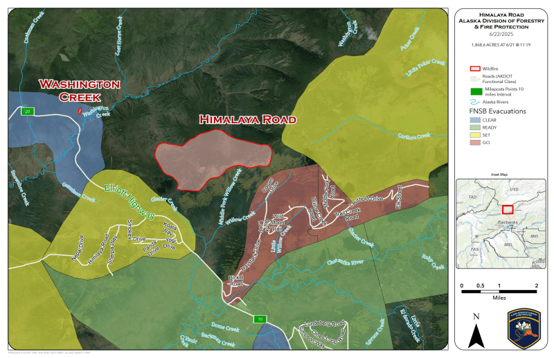
Update 5:30 PM – Increased fire activity on the Himalaya Road Fire has challenged dozer lines along the eastern edge and wind driven conditions have led the Fairbanks North Star Borough to upgrade evacuation levels in the fire area. Firefighters are working to establish contingency lines along the Elliott Highway. Law Enforcement has been working with the Borough to ensure safe and efficient evacuations. Firefighters are coordinating with Alaska DOT to facilitate safe travel through the area as soon as possible. Due to fire activity, the Elliot highway is closed temporarily from approximately Haystack Dr to Milepost 20. Visit 511.alaska.gov for current road conditions and closures.
Current evacuation levels are as follows:
![]() Level 3 “GO!”:
Level 3 “GO!”:
- Properties on ALL roads of Haystack Mountain
- Poker Flat Watershed
- Himalaya area
- Hayes Creek area
![]() Level 2 “SET”:
Level 2 “SET”:
- Old Chatanika
- At Your Own Risk
- Elliott Highway MP 17-31
![]() Level 1 “READY”:
Level 1 “READY”:
- Northeast of Steese Highway MP 30-45
- Poker Flat Facility
- Olnes
Current evacuation map for Fairbanks North Star Borough
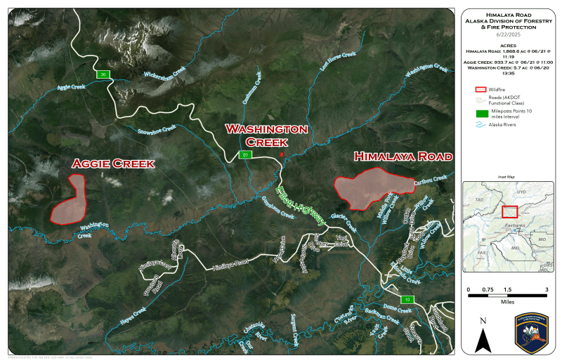
UPDATE 12:30 PM — The Himalaya Road Fire (#223), 1,868 acres, is being managed as part of a group with the Aggie Creek Fire (#268), 934 acres, and the Washington Creek Fire (#232), 5.7 acres, estimated at approximately 1,868 acres and is burning near Elliott Highway MP 15. The Himalaya fire crossed a fuel break on the eastern flank on Saturday backed downhill. Tankers have been used to slow fire spread, A Southwest area Complex Incident Management Team will be inbriefed on Monday to assume command of these fires. The Aggie Creek Fire is approximately 934 acres and is burning north of Washington Creek, 6 miles southwest of Elliot Highway MP 21. It displayed active fire behavior again on Saturday. Additional air and ground resources will be on scene today.
Fairbanks North Star Borough has increased evacuation levels around the fire area:
![]() Level 3 “GO!”: In effect for properties on ALL roads of Haystack Mountain.
Level 3 “GO!”: In effect for properties on ALL roads of Haystack Mountain.
![]() Level 2 “SET”: In effect for Hayes Creek Neighborhood and Poker Flat Watershed.
Level 2 “SET”: In effect for Hayes Creek Neighborhood and Poker Flat Watershed.
![]() Level 1 “READY”: In effect for At Your Own Risk & Chatanika.
Level 1 “READY”: In effect for At Your Own Risk & Chatanika.
The Gilmore Trail Fire (#233), 15.5 acres, is burning off the end of Gilmore Trail, east of Fox. It experienced no growth on Saturday and mop up is ongoing today. Evacuation levels 1 and 2 (READY, SET) remain in place as resources continue to work toward full containment.
The Twelvemile Lake Fire (#220), 6,221 acres,is located outside of Delta Junction northeast of Twelvemile Lake. The fire experienced increased activity yesterday and grew over 4,000 acres. Structure protection is ongoing in the area, DOF resources are actively engaged on three wildfires in this area, the Twelvemile Lake Fire, Lake George Fire (#224), and Sand Lake Fire (#292). Ground and aerial resources are being supported by boating operations to deliver protection kits for structures around the lakes. Current weather forecasts indicate that these fires could threaten structures within the next two days. Firefighting operations around the lakes will create more air and water traffic than usual. We ask that residents, visitors and homeowners in the area of Twelvemile Lake, Healy Lake, Sand Lake and Lake George travel with caution on waterways and roadways. There is currently no TFR (Temporary Flight Restriction) over this area at this time, but this may change along with an increase in fire activity. Please remain alert and be prepared for rapidly changing conditions.
Categories: Active Wildland Fire, AK Fire Info, Alaska DNR - Division of Forestry (DOF)
