Bear Creek Fire (#237): 26,047 acres
Saint George Creek Fire (#246): 20,369 acres
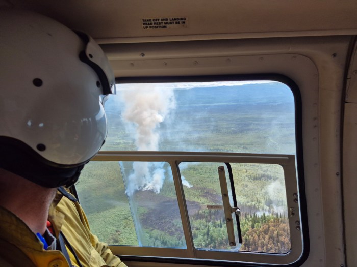
The sunny skies and increased breeze intensified fire behavior yesterday and put up some smoke plumes. Fire behavior remains primarily creeping, smoldering, and single-tree torching. The forecast indicates a good chance of scattered showers with wetting rain today. Southerly winds will switch to the southwest in the evening.
Erick Stahlin, AKCIMT
Bear Creek Fire. Bulldozer line is being installed on the north side of the fire to keep the fire from creeping into the agricultural area to the north. Efforts are continuing on the east side to confine the fire west of the Nenana River. On the west side, the fire is burning into a previously burned area and is not likely to spread significantly.
Structure work continues in Bear Creek where crews are mopping up and assessing conditions. Water and retardant drops were made in the Washington Drive/June Creek subdivision area to slow fire activity as crews worked in the area on structure protection. This work is expected to continue for at least 2-3 days, depending on conditions.
Saint George Creek Fire. Mop up continues around structures in the southwest corner of the fire area to ensure remaining heat is extinguished. Crews are also prepping structures just outside the fire perimeter to protect them from potential threat. A new crew is coming in today to relieve the hard-working crew that has been there since the fire began. Assessments are in progress to determine the extent of damage to structures in both fire areas.

Join us at a community meeting! A community meeting will be held on Thursday, June 26 at the Tri-Valley School at 6 p.m. Fire managers will provide updates on operations and fire activity, and attendees will have an opportunity to ask questions.
Evacuations remain in place and unchanged. The evacuation shelter is moving from the Baptist Church to the Tri-Valley School in Healy today. For the most accurate information and maps visit the Denali Borough website (denaliborough.org) or Facebook page (facebook.com/denali.borough). You may also call or text the Denali Borough Fire Info line between 7 a.m. and 9 p.m. at 907-378-7985.
Traffic control on the Parks Highway will remain in place for firefighter and motorist safety. Even though fire activity has decreased, there is still fire danger and heavy equipment working along the highway. Expect pilot car escorts and delays. Check road conditions on the Alaska Department of Transportation website (511.alaska.gov).
If you fly, we can’t! A temporary flight restriction (FDC 5/8646) is in place for the fire area to protect firefighter safety. Drones are prohibited in this area; any use of drones will ground aircraft and may endanger firefighters.
More information: Follow more information about Alaska fires on Alaska Wildland Fire Information (akfireinfo.com) and on social media (facebook.com/AK.Forestry). For information about fires in Alaska, call 907-356-5511.
Categories: Active Wildland Fire, AK Fire Info, Alaska DNR - Division of Forestry (DOF)
