Fire crews continue suppression efforts as moderated fire activity leads to good progress on protecting residences east of the Himalaya Road Fire (#223).
Yesterday, air operations supported efforts by dropping water on the fire east of Haystack Road to address a flare-up. Today, fire crews will continue to construct fire line between the west and south side of the Himalaya Road Fire away from residences and structures and reinforce containment line towards the Elliot Highway. Work on a containment line on the Haystack Mountain ridgeline north of residences Tuesday will continue to progress north to further improve the fuel break. On the Aggie Creek Fire (#268), crews scouted potential fire line locations in steep, forested terrain and continue to protect cabins near Washington Creek. A dozer line was completed along the perimeter of the Washington Creek Fire (#232). Fire activity is expected to be moderated by moist weather today.

Moist conditions are expected for the next several days, with Thursday being the best chance for wetting rains. Scattered smoldering but no perimeter growth and little smoke production anticipated. A potential drying pattern beyond Friday could produce a return to surface spread with torching.
For smoke and air quality go to airnow.gov.
No road closures reported. Check 511.alaska.gov for road conditions.
Level 1 “READY,” Level 2 “SET,” and Level 3, “GO!” evacuations are all in effect for these fires. Visit Fairbanks North Star Borough for current evacuation levels. The Red Cross has opened an evacuation shelter at Hutchison High School, 3750 Geist Rd.
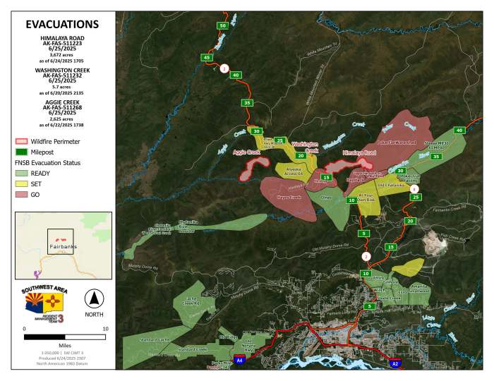
Please stay out of the fire area. Drive with caution. Expect delays and poor visibility due to smoke and fire crews working along roadways. A new Temporary Flight Restriction is in place above the fires. Do not fly drones over the fire area; if you fly, we can’t. Unauthorized drone use poses serious risks to firefighter and public safety.
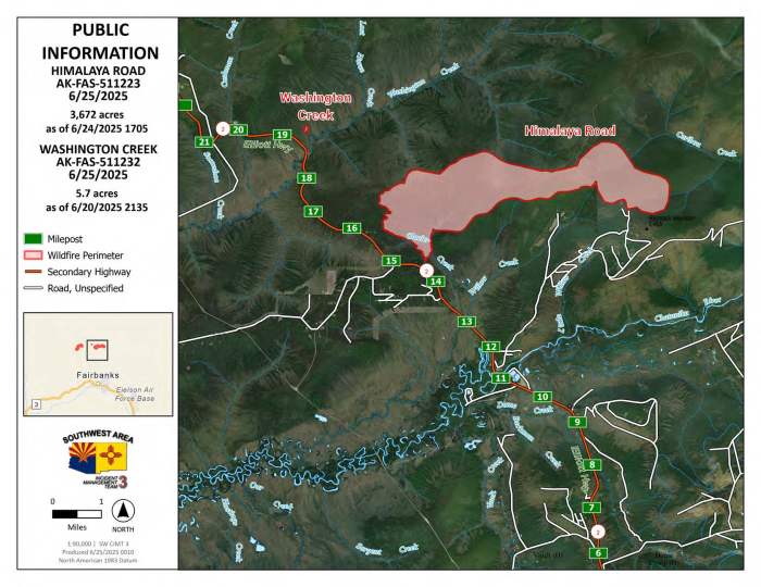
Acres: 3,425 (Himalaya Road); 2,625 (Aggie Creek), 5.7 (Washington Creek)
Start Date: June 19, 2025
Location: Fairbanks North Star Borough
Cause: Lightning
Personnel: 162
Fuels: Black spruce, grass
Containment: 0%
Public Information/Media Phone Number: 907-921-7881 from 9 am to 9 pm
Website: https://akfireinfo.com/
Email: 2025.himalayaroad@firenet.gov
Categories: Active Wildland Fire, AK Fire Info, Alaska DNR - Division of Forestry (DOF)
