Evacuation levels for neighborhoods near the 7 Mile Lookout Fire (#222): Residents on Butch Kuth Ave, Osprey, Moose Nugget, and Goshawk Rd are at Level 2 “SET”. Residents north of Butch Kuth Ave and on Jack Wade Rd are at Level 1 “READY”. Please be cautious when traveling in the area and watch for emergency personnel.

The temporary flight restriction (TFR) is still in place over the fire and will continue to be until further notice.
The 7 Mile Lookout Fire is located 9 miles southwest of Tok and has a current estimated size of 1,373 acres. Fire activity and smoke was reduced on Wednesday due to cooler temperatures and increased moisture. Additional personnel have arrived on scene to support suppression efforts. The White Mountain Type 2 Initial Attack Crew and the Clackamas Type 2 Crew, who arrived from Oregon on Wednesday, continue to utilize a hose lay over two miles long to address areas of heat. Assisted by smokejumpers, fire crews continue to improve and secure dozer lines. Four dozers continue to expand containment lines to keep the fire south of the Eagle Trail and west of the 7 Mile Access Rd. Fire personnel are patrolling at night to monitor fire activity. Two resource advisors, who record disturbance to natural and cultural resources caused by suppression efforts, and one field observer, who collects intel on the fire for planning and mapping, have been assigned to the fire.
Tok River Fire (#289), located 10 miles south of Tok, is currently estimated at 278 acres. Dozers are working to establish a fire line starting west of the Tok River and moving north. A dozer trail from the Glenn Highway Tok Cutoff to the fire camp was connected. A helitack crew supporting helicopter sling load operations and the Tanana Chiefs Conference Fire Crew continue suppression efforts. Cooler temperatures paired with rain have reduced fire activity.
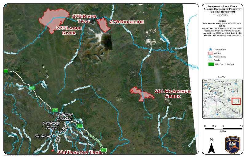
Tractor Trail Fire (#334), located 4 miles south of Northway, is estimated at 88 acres. Smokejumpers have worked to install hose around 100% of the fire. Cooler temperatures, rain, and the efforts of firefighters have reduced fire activity. Aerial support was shifted to other incidents due to the significant progress made on the fire.

A UAS (Unmanned Aerial System/drone) module collected fire perimeter and hotspot detection intelligence on the Tok River Fire and the 7 Mile Lookout Fire on Wednesday and Thursday to obtain more accurate data to improve suppression plans and efforts.
Lake Mansfield Fire (#282), which may be visible from the road, is located 26.5 miles northwest of Tok and is estimated at 688 acres. Additional support has been ordered, and it is currently being monitored.
Limited Protection Area Fires (East of Tok)
The River Trail Fire (#276) is located 15 miles east of the Taylor Highway and is estimated at 19,900 acres. The Ridgeline Fire (#278) is located 30 miles east of the Taylor Highway and is estimated at 4,500 acres. Neither fire is currently threatening any communities or structures.
The McArthur Creek Fire (#281) is located 58 miles east of Tok and 45 miles southeast of the Taylor Highway. It is estimated at 5,400 acres. Additional resources have been ordered to assess structures in the area.
While cooler temperatures and precipitation have reduced fire activity, fire managers remain on alert for new starts and increased fire activity as lightning continues in the area and higher temperatures are expected.
For more information, please call the Tok Fire Information Line: (907) 505-0362
Categories: Active Wildland Fire, AK Fire Info, Alaska DNR - Division of Forestry (DOF)
