Firefighters put in hard work preparing lines and extinguishing hotspots around the Ptarmigan Complex over the past few days, taking advantage of the cooler, wetter weather. A warming, drying trend is forecast for the next five days. This brings the potential for thunderstorms with lightning and drier fuels that are more receptive to fire.

Turtle Fire (#243) – Eight smokejumpers are reinforcing the line around an Alaska Native allotment boundary near Mile 148 on the Steese Highway. The Paradise Valley Type 2 hand crew and the Council of Athabaskan Tribal Governments Type 2 wildland firefighting crew continue to improve the indirect line in the area and add pumps and hoses to the lines. Isolated smoke was visible from the road as both the north and south flanks of the fire continue to show signs of smoldering heat.
Alligator Fire (#265) – Continuous heat was present on the north flank of the fire. Four smokejumpers and the Alaska Range Module are constructing line, laying hoses along the lines, and looking for hotspots on the northwest shoulder of the fire. The Smith River Hotshots are working on the northeastern corner of the fire, putting in line and hoses as they moving west toward the smokejumpers. Isolated heat is present on the heel of the east and west flanks. There is also heat showing in the spruce stringers by Albert Creek.
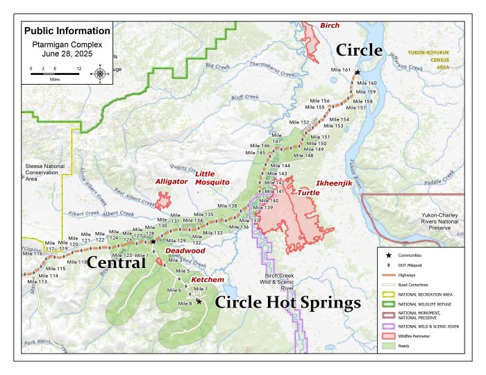
Birch Fire (#256) – No visible smokes were seen Sunday on the eastern flank. Lingering smoke was still present in the area between the main edge of the fire and Birch Creek. The Black Hills Wildland Fire Module secured and mopped up the northwestern corner of the fire. They are now constructing indirect handline from the fire’s edge to Birch Creek. When this is done, they will move to the southern edge of the fire where some heat is still present.
The Deadwood Fire (#214) is in monitor status. The Ketchem Fire (#240) and Little Mosquito Fire (#241) are out.
A Level 1 “Ready” Alert remains in effect for the community of Central, the Steese Highway from Milepost 123 to Milepost 151, Circle Hot Springs Road and Circle Hot Springs, and Deadwood Creek Road. Drivers should expect traffic delays on the Steese Highway, Circle Hot Springs Road, and Deadwood Creek Road due to firefighting operations. A Level 1 “Ready” alert means: begin preparing for a potential evacuation; make plans for family members with special needs, pets, or livestock; gather essential items such as prescriptions, important documents, and valuables; and stay alert and watch for updates from local authorities.
NOTAM #06/201 is in place for the Central Airport (CEM): Increased air traffic 5,000 ft MSL and below within a 20 nautical mile radius of the Central Airport (CEM) due to firefighting aviation operations.
Download a PDF of this update HERE.
-BLM-
Bureau of Land Management, Alaska Fire Service, P.O. Box 35005 1541 Gaffney Road, Fort Wainwright, AK 99703
Need public domain imagery to complement news coverage of the BLM Alaska Fire Service in Alaska? Visit our Flickr channel!
Learn more at http://www.blm.gov/AlaskaFireService, and on Facebook and Twitter.
The Bureau of Land Management Alaska Fire Service (AFS) located at Fort Wainwright, Alaska, provides wildland fire suppression services for over 240 million acres of Department of the Interior and Native Corporation Lands in Alaska. In addition, AFS has other statewide responsibilities that include: interpretation of fire management policy; oversight of the BLM Alaska Aviation program; fuels management projects; and operating and maintaining advanced communication and computer systems such as the Alaska Lightning Detection System. AFS also maintains a National Incident Support Cache. The Alaska Fire Service provides wildland fire suppression services for America’s “Last Frontier” on an interagency basis with the State of Alaska Department of Natural Resources, USDA Forest Service, National Park Service, Bureau of Indian Affairs, U.S. Fish and Wildlife Service, and the U.S. Military in Alaska.
Categories: Active Wildland Fire, AK Fire Info, BLM Alaska Fire Service
