
SW Complex IMT 3
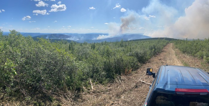
Highlights: Widespread smoke from the Aggie Creek (#268) and the Himalaya Road (#223) fires was visible from many areas Tuesday as fire activity escalated in response to warm dry weather and northeasterly winds. On the Glacier Creek side of the Himalaya Road Fire, scoopers and an air tanker dropped water and retardant to suppress spot fires near residences and the Elliott Highway. Firefighters monitored the Aggie Creek Fire where growth intensified in the west and southeast perimeters throughout the afternoon. Crews were able to further reinforce the sprinkler system on a cabin near Washington Creek which remains intact.

Operations: Firefighters anticipate fire activity to increase today and into the week, especially on the western perimeters. A full fleet of aerial resources will again assist firefighters in suppressing and monitoring the Aggie Creek Fire (#268), the Washington Creek Fire (#232) and the Himalaya Road Fire (#223). Masticators will continue to work on contingency lines near the Aggie Creek Fire. On the Himalaya Road Fire, firefighters will secure direct line to the south near Skinny Dip and Glacier Creek, and ensure sprinklers and pumps are ready to activate near homes.
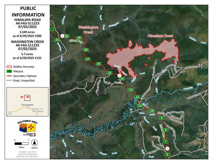
Numbers:
Aggie Creek Fire (#268): 2,797 acres, 0% contained
Himalaya Road Fire (#223): 3,543 acres, 0% contained
Washington Creek Fire (#232): 5.7acres, 0% contained
Weather: Wednesday is a critical fire weather day and a Red Flag Warning is in effect. Gusty winds, combined with several days of warming and drying, are expected to increase fire activity.
Smoke: For air quality, go to www.airnow.gov. For smoke outlook updates go to https://outlooks.airfire.org/outlook/e16e3fa2.
Closures: No road closures reported. Check https://511.alaska.gov/map for road conditions. Alaska State Parks has closed Olnes Pond and the Whitefish Campground due to fire activity.
Evacuations: Level 1 “READY,” and Level 2 “SET,” evacuations are in effect for these fires. SET means be ready to evacuate on a moment’s notice. Visit https://bit.ly/FNSBevac for current evacuation levels.

Safety: Drivers are urged to be alert, go slow and watch out for firefighters and heavy equipment along Elliott Highway and other roads. Stay out of the active fire area and firefighter staging areas. A Temporary Flight Restriction is in place. Do not fly drones over the fire area; if you fly, we can’t. Unauthorized drone use poses serious risks to firefighter and public safety.
Information: Call 907-921-7881 (9 a.m. to 9 p.m.) or email 2025.himalayaroad@firenet.gov
Categories: Active Wildland Fire, AK Fire Info, Alaska DNR - Division of Forestry (DOF)
