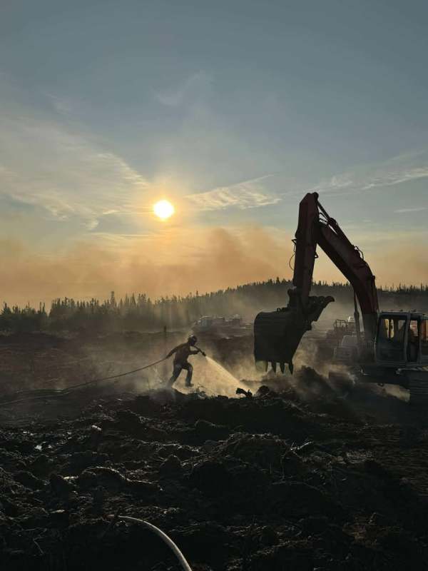
Firefighters, pilots and heavy equipment operators spent a hot, dry and smoky Fourth of July protecting residences and connecting line around perimeters of both the Aggie Creek Fire (#268) and Himalaya Road Fire (#223).
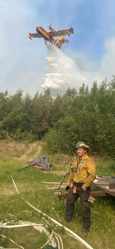
The Aggie Creek Fire continued to push west into old burn scars and north towards the Alaska Pipeline where masticators reduced vegetation. Firefighters checked pumps and sprinklers installed to defend structures on Himalaya Loop Road. Crews on the Himalaya Road Fire held the encroaching fire on the dozer line near Cogan Drive and prevented it from impacting Middle Fork Road. Three small spot fires on the northwest side were lined by crews. Aircraft dumped water and retardant to support ground crews but smoky conditions grounded the fleet at 6 p.m.

Operations: Today will be the hottest day since the fires started. On the Himalaya Road Fire, firefighters and dozers, assisted by aircraft, will work aggressively to hold containment lines in Leuthold, Upper Haystack and Haystack areas. Fire spread remains problematic in this area and requires constant vigilance. Direct fire line construction will continue in the Glacier Creek drainage along the perimeter. Heavy equipment will work the Aggie Creek Fire today, concentrating on heat northwest near the pipeline and Himalaya Road loop to protect residences. Ground crews will continue to install hose lay and pumps and extinguish hot spots, monitor fire growth and use aircraft to deliver water and retardant to protect structures in the Hayes Creek area.

Numbers:
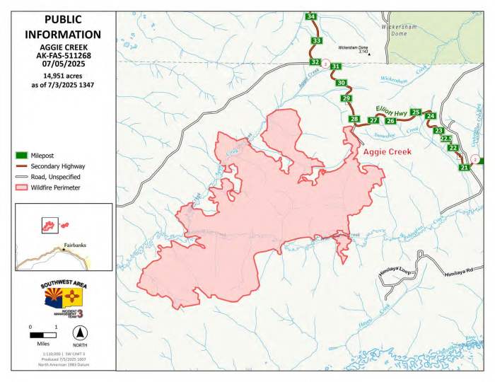
Aggie Creek Fire (#268): 14,951 acres, 0% contained
Himalaya Road Fire (#223): 4,656 acres, 0% contained
Weather: Saturday will be the hottest day of the week with extremely dry fuels and low humidity. Winds will be breezy with gusts to 20 mph out of the northeast in the afternoon.
Smoke: For smoke outlook updates go to fire.airnow.gov
Closures: No road closures reported at this time. Check 511.alaska.gov for road conditions. Olnes Pond and the Whitefish Campground are closed due to fire activity.
Evacuations: Level 1 “READY,” and Level 2 “SET,” evacuations are in effect for these fires. SET means be ready to evacuate on a moment’s notice. Visit FNSB Evacuation Zone Monitor Map for current evacuation levels.

Safety: Drivers must use extreme caution on Elliott Highway. Do not stop, be alert and watch out for firefighters and heavy equipment working the area. Smoke may limit visibility at times. A Temporary Flight Restriction is in place. Do not fly drones over the fire area; if you fly, we can’t. Unauthorized drone use poses serious risks to firefighter and public safety.
Information: Call 907-921-7881 (9 a.m. to 9 p.m.) or email 2025.himalayaroad@firenet.gov
Categories: Active Wildland Fire, AK Fire Info, Alaska DNR - Division of Forestry (DOF)
