Updated post – (5:15 p.m.) A Level 1 “READY” evacuation notice has been set for Eureka and residences along the Eureka-Rampart Trail due to increased wildfire activity in the area.
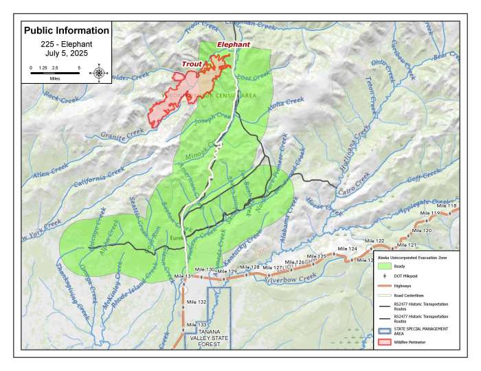
This area includes the Eureka Road beginning at MP 130 of the Elliott Highway, extending north to the Eureka-Rampart Trail. It also includes the community of Eureka and stretches north past a cluster of structures near Granite Creek.
A Level 1 “READY” notice means residents should prepare their properties by creating defensible space. This includes relocating or removing combustible materials such as debris, loose fuel containers, vehicles, or other ignition sources near homes. Remove items that could trap embers and ignite a structure. Keep grass, trees, and vegetation near homes trimmed and cleared.
Now is also the time to begin making a plan in case the evacuation level increases. Create an evacuation action plan and assemble emergency supplies, important documents, and personal belongings in a safe, easily accessible location.
The Elephant Fire (#225) made an approximately 2-mile run south on Friday toward Eureka, between Granite Creek and Minook Creek.
If the fire continues to approach, Eureka residents should follow the directions of local authorities.
For updates on fires in the area, visit: akfireinfo.com/tag/lush-fire
Original post – (12:00 p.m.) A RED FLAG WARNING is in effect for the Lush Fire (#199) and other fires in the Tanana Fire Management Zone. Winds are forecast to be out of the east with 5 to 15 miles per hours (mph) sustained and gusts up to 30 mph. Humidity levels are expected to be as low as 21%. Due to these weather conditions, rapid ignition, growth and spread of fires is possible.
Yesterday, fire behavior on the Lush Fire (#199) was active with torching and running when the fire was aligned with fuels. The fire burned actively, even in hardwood fuel types. Firefighters continue to hold line on the southwestern corner of the fire. Areas of heat on this corner of the fire are south of Lush Creek. The fire was active on the north side, west of Susie Creek. Firefighters will continue to make progress on indirect line construction around Alaska Native Allotments. Aviation resources will be used for reconnaissance flights and to drop water where needed.
Today, one additional hotshot hand crew will arrive to the fire today. Firefighters will continue working on their indirect lines to continue holding and protecting values at risk. They will work direct along the Yukon River, between Sarah Creek and Susie Creek.
The Elephant Fire (#225) made and approximate two mile run south towards Eureka, between Granite Creek and Minook Creek. The priority for fire managers today will be to conduct a reconnaissance flight and assess needs. Three smokejumpers will be moved today from the Lush Fire to help with this mission.
Yesterday, firefighters on the Dugan Fire (#354) continued their work gridding the fire for any areas of heat. Today, they will do a final gridding of the fire and plan to pull hose from around the fire perimeter.
Overall, fire managers are monitoring 40 other fires in the Tanana Zone and will staff those fires if conditions warrant.
-BLM-
Bureau of Land Management, Alaska Fire Service, P.O. Box 35005 1541 Gaffney Road, Fort Wainwright, Ak 99703
Need public domain imagery to complement news coverage of the BLM Alaska Fire Service in Alaska? Visit our Flickr channel!
Learn more at http://www.blm.gov/AlaskaFireService, and on Facebook.
The Bureau of Land Management Alaska Fire Service (AFS) located at Fort Wainwright, Alaska, provides wildland fire suppression services for over 240 million acres of Department of the Interior and Native Corporation Lands in Alaska. In addition, AFS has other statewide responsibilities that include: interpretation of fire management policy; oversight of the BLM Alaska Aviation program; fuels management projects; and operating and maintaining advanced communication and computer systems such as the Alaska Lightning Detection System. AFS also maintains a National Incident Support Cache. The Alaska Fire Service provides wildland fire suppression services for America’s “Last Frontier” on an interagency basis with the State of Alaska Department of Natural Resources, USDA Forest Service, National Park Service, Bureau of Indian Affairs, U.S. Fish and Wildlife Service, and the U.S. Military in Alaska
Categories: Active Wildland Fire, AK Fire Info, BLM Alaska Fire Service
