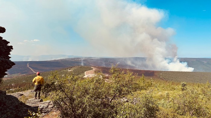
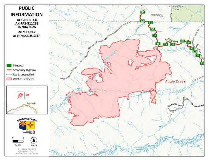
Fire crews are preparing an aggressive suite of actions to herd the Aggie Creek Fire (#268) away from structures after it grew to 20,752 acres yesterday. On Saturday, the fire crested the ridge on the northside of the Chatanika River and crept south, backing into the river corridor. To the northeast, firefighters began backburning to control the spread heading northeast towards the Alaska Pipeline and Elliott Highway. A fleet of aircraft including super scoopers and three helicopters dropped water on the fires. Firefighters held the line on the Himalaya Road Fire (#223) and prevented the fire from crossing into the bottom of Caribou Creek.
Operations: Today, firefighters will use watercraft to survey the Aggie Creek Fire from the Chatanika River and assess protective strategies for homes and structures. A Level 2 “SET” evacuation order is in place for residents along the river. Crews will also continue arduous mop up in challenging terrain on both fires. Dozers and other heavy equipment will work the containment and contingency lines around the perimeters and scout for areas to improve. Ground crews on the Himalaya Road Fire will continue to connect containment and contingency lines to keep the fire within its perimeter and check water systems in place to protect residences. The fleet of aircraft will again support firefighter efforts on the ground.


Numbers:
Aggie Creek Fire (#268): 20,752 acres, 0% contained
Himalaya Road Fire (#223): 5,477 acres, 0% contained
Weather: A change of weather is in store for Sunday as winds pivot from the northeast to the southwest. The change will bring some cooler temperatures and higher humidity, and a chance for thunderstorms.
Smoke: For smoke outlook updates go to outlooks.airfire.org.
Closures: No road closures reported at this time. Check 511.alaska.gov for road conditions. Olnes Pond and the Whitefish Campground are closed due to fire activity.
Evacuations: Level 1 “READY,” and Level 2 “SET,” evacuations are in effect for these fires. “SET” means be ready to evacuate on a moment’s notice. Visit https://bit.ly/FNSBevac for current evacuation levels.

Safety: Drivers must use extreme caution on Elliott Highway. Do not stop, be alert and watch out for firefighters and heavy equipment working the area. Smoke may limit visibility at times. A Temporary Flight Restriction (TFR) is in place. Do not fly drones over the fire area; if you fly, we can’t. Unauthorized drone use poses serious risks to firefighter and public safety.
Information: Call 907-921-7881 (9 a.m. to 9 p.m.) or email 2025.himalayaroad@firenet.gov
Categories: Active Wildland Fire, AK Fire Info, Alaska DNR - Division of Forestry (DOF)
