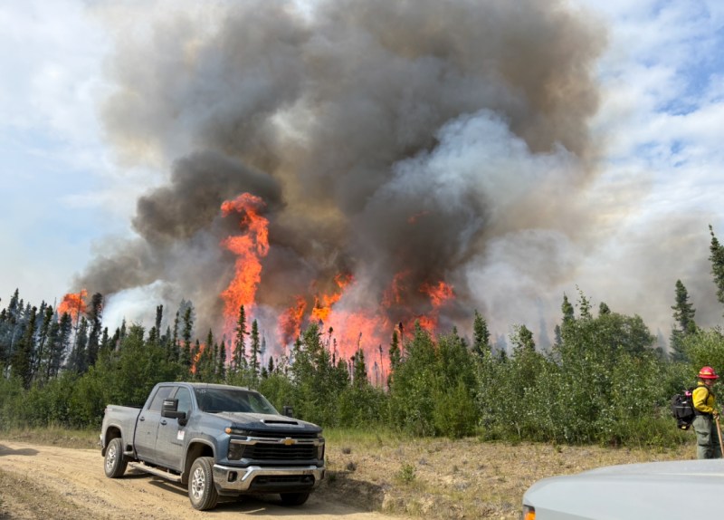
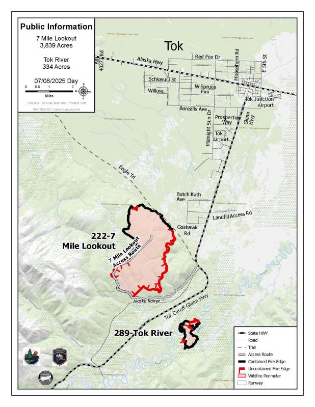
7 Mile Lookout Fire (#222)
Size: 3,839 acres Location: 7 miles southwest of Tok, AK.
Start Date: June 19, 2025 Cause: Lightning Containment: 54%
Total Personnel: 145
Evacuation levels for neighborhoods near the 7 Mile Lookout Fire (#222): Residents north of Butch Kuth Ave and on Jack Wade Road are at READY (Level 1). Residents on Osprey, Moose Nugget, and Goshawk Roads are at SET (Level 2).
Yesterday’s Activities: On the east side of the fire, heat remains in the same areas as before; however, fire activity has significantly decreased due to favorable weather conditions yesterday. On the southwest side, effective communication, strong leadership, and optimal burning conditions enabled crews to successfully carry out a burn operation on the east side of the 7 mile lookout route. A small spot fire was found through infrared mapping and targeted bucket drops extinguished the area. Crews continued to mop up and treat areas with heat observed.
Today’s Activities: Firefighters will be securing any hotspots that have been previously worked on to ensure containment. Depending on burning conditions, crews will continue burn operations to extend further down the east side of the 7 mile lookout route, as well as burn more in the interior to tie into the black (burned) area. If time permits, crews will begin mopping up along the completed burnout along the 7 mile lookout route. Additionally, a crew will be scouting an area near the south section of the fire to potentially burn through a drainage and connect the south end of the perimeter with the previously prepped area.
Tok River Fire (#289)
Size: 334 acres Location: 10 miles south of Tok, AK.
Start Date: June 19, 2025 Cause: Lightning Containment: 83%
Total Personnel: 39
Activities – Containment efforts continue to make steady progress, with fire containment now at 83%. More containment line is expected to be added today as operations remain on track. Crews will continue mop-up, hot-spotting, and gridding operations in the boggy terrain on both sides of the river. So far, crews have gridded 50 feet into the fire’s interior and have established a saw line near the perimeter. Today, they plan to extend gridding up to 100 feet inward. Overall, the Tok River Fire remains on a positive trajectory.
Weather – Rain showers are possible throughout the day, especially in the afternoon. Mostly cloudy skies will prevail, with the strongest winds expected tomorrow—up to 10 mph at ridgetops from the southwest. Humidity will decrease to around 45–55%, and maximum temperatures will remain in the low 60s°F.
Aircraft and Drone Restrictions – A temporary flight restriction (TFR) is still in place over the fire and will continue to be until further notice. The public is asked not to fly any type of aircraft, including drones, near the fire area. Unauthorized drone (UAS) flights pose serious risks to the effectiveness of wildfire suppression operations. Aerial firefighting is suspended when unauthorized UAS are in the area, allowing wildfires to grow larger.
Remember: If you fly, we can’t.
Categories: Active Wildland Fire, AK Fire Info, Alaska DNR - Division of Forestry (DOF)
