The Roundabout Complex is now 47,819 acres, with all 2,300 acres of growth yesterday occurring on the Moldy Fire (#279). The expansion was concentrated on the southeast corner near Roundabout Mountain. Dry conditions persist with no rainfall received and no precipitation expected until after the weekend.
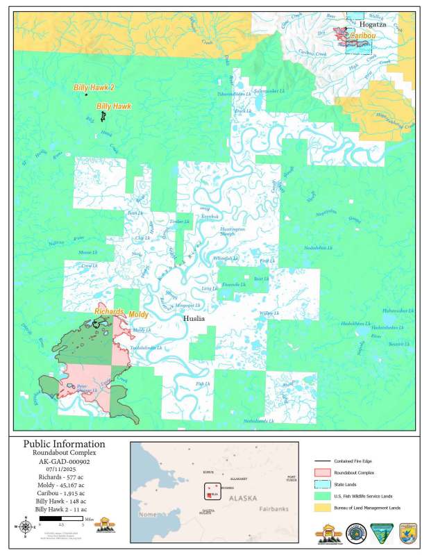
Moldy Fire (#279) – Fire crews remain focused on protecting values at risk, including Alaska Native allotments and structures along the Koyukuk River near Huslia, as well as critical communications infrastructure. The Plumas Hotshots module completed their work securing the fire’s edge near Butch’s Cabin on the south side of the Moldy Fire. Today, they are relocating upriver to rejoin the module that has been preparing structures and allotments near Huslia. Zigzag Hotshots continued their efforts along the Dagitli River, south of a threatened allotment, working to ensure the fire does not encroach further into that area. Tomorrow, they will move upriver to a group of allotments previously treated, where they will improve line and install hose for additional protection. The Flagstaff Hotshots are expected to arrive today and will be critical in helping meet the incident’s primary objectives.
Caribou Fire (#128), Richards Fire (#251), Billy Hawk Fire (#182), and Billy Hawk 2 Fire (#191) – No changes reported. All four fires remain in monitor status with no new activity.
To print this update, find a PDF version here.
-BLM-
Bureau of Land Management, Alaska Fire Service
P.O. Box 35005 1541 Gaffney Road, Fort Wainwright, AK 99703
Need public domain imagery to complement news coverage of the BLM Alaska Fire Service in Alaska? Visit our Flickr channel!
Learn more at http://www.blm.gov/AlaskaFireService, and on Facebook.
The Bureau of Land Management Alaska Fire Service (AFS) located at Fort Wainwright, Alaska, provides wildland fire suppression services for over 240 million acres of Department of the Interior and Native Corporation Lands in Alaska. In addition, AFS has other statewide responsibilities that include: interpretation of fire management policy; oversight of the BLM Alaska Aviation program; fuels management projects; and operating and maintaining advanced communication and computer systems such as the Alaska Lightning Detection System. AFS also maintains a National Incident Support Cache. The Alaska Fire Service provides wildland fire suppression services for America’s “Last Frontier” on an interagency basis with the State of Alaska Department of Natural Resources, USDA Forest Service, National Park Service, Bureau of Indian Affairs, U.S. Fish and Wildlife Service, and the U.S. Military in Alaska.
Categories: Active Wildland Fire, AK Fire Info, BLM Alaska Fire Service
