Moderate fire activity was present yesterday with creeping and smoldering observed. Individual trees were observed torching on the Turtle Fire (#243) and individual smokes were visible from the Buckley Bar Fire (#264). The area expects to see a warming and drying trend for the weekend. This may lead to an increase in fire activity and smoke.

A drone equipped with thermal imaging capability, referred to as a UAS (uncrewed aerial system) module, has been assigned to the Ptarmigan Complex. The drone will be used to detect possible remaining heat along the perimeters of fires within the complex. Members of the public should be aware that a Temporary Flight Restriction (TFR) will be in place for areas where the UAS module is working each day. Please check FAA.gov for updated TFR and NOTAM notices in the area. Remember, if you fly, we can’t!
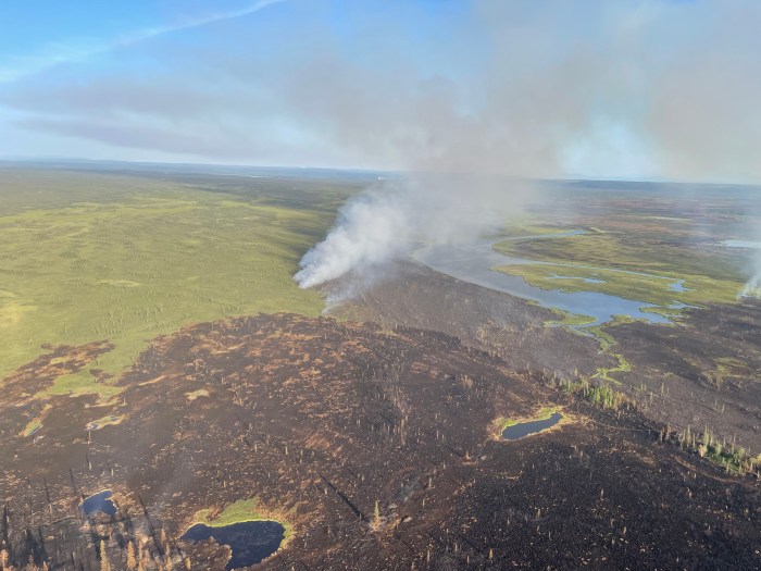
Turtle Fire (#243) –The Tatanka Hotshots, Smith River Hotshots, and the Alaska Range Module are utilizing direct tactics on the north end of the fire, and are working towards each other’s lines. The Alaska Range Module will remain spiked out on the fire near the established helispot located on the northern edge of the Turtle Fire. Smith River will continue to be inserted daily using helicopters. The Birch Creek Remote Automatic Weather Station (RAWS) sensors were reinstalled on the station yesterday. Firefighters will be scouting to locate additional values at risk along the Yukon River. On the south and east portions of Turtle, fire behavior continues to be moderate, and minimal activity was observed.
The Turtle Fire was started by lightning. It was reported on June 19 and is burning about 10 miles east of Central, AK and 12 miles south of Circle, AK.
Buckley Bar (#264) – Siskiyou Rappellers engaged in point protection and created defensible space around the Old Trapper Cabin, and were then extracted in the evening of July 11. A helispot was located near Birch Cabin, and the rapellers will also set up point protection and create defensible space around it and the other historic cabins throughout today. The fire lies about 17 miles to the southwest of Central. It was discovered on June 20 and was caused by lightning.
Deadwood Fire (#214) – The drone module (UAS) flew the perimeter of the fire yesterday and found no heat. The fire will remain in monitor status. The Deadwood Fire was started by lightning, discovered on June 20, and is in Central, AK.

Birch Fire (#256) – With warmer and drier days, the fire begin to put up smoke on the northeast end of the fire towards the end of the day on July 11. Today, firefighters will take direct action along the fire’s edge to slow the spread. The Birch Fire remains on the east side of Birch Creek. The fire was discovered on June 20, caused by lightning, and is about 4 miles northwest of Circle, AK.
Alligator Fire (#265) – The drone module (UAS) will be working on the Alligator Fire for the next several days, and will fly the perimeter looking for any heat by utilizing thermal imaging. The fire was discovered on June 20, started by lightning, and is about 3 miles north of Central, AK.
A Level 1 “Ready” Alert remains in effect for the community of Central, the Steese Highway from Milepost 123 to Milepost 151, Circle Hot Springs Road and Circle Hot Springs, and Deadwood Creek Road. Drivers should expect traffic delays on the Steese Highway, Circle Hot Springs Road, and Deadwood Creek Road due to firefighting operations. A Level 1 “Ready” alert means: begin preparing for a potential evacuation; make plans for family members with special needs, pets, or livestock; gather essential items such as prescriptions, important documents, and valuables; and stay alert and watch for updates from local authorities.
NOTAM #: 07/118 is in place for the Central Airport (CEM): Increased air traffic 5,000 ft MSL and below within a 20 nautical mile radius of the Central Airport (CEM) due to firefighting aviation operations.
View printable update of PDF here.
-BLM-
Bureau of Land Management, Alaska Fire Service
P.O. Box 35005 1541 Gaffney Road, Fort Wainwright, AK 99703
Need public domain imagery to complement news coverage of the BLM Alaska Fire Service in Alaska? Visit our Flickr channel!
Learn more at http://www.blm.gov/AlaskaFireService, and on Facebook.
The Bureau of Land Management Alaska Fire Service (AFS) located at Fort Wainwright, Alaska, provides wildland fire suppression services for over 240 million acres of Department of the Interior and Native Corporation Lands in Alaska. In addition, AFS has other statewide responsibilities that include: interpretation of fire management policy; oversight of the BLM Alaska Aviation program; fuels management projects; and operating and maintaining advanced communication and computer systems such as the Alaska Lightning Detection System. AFS also maintains a National Incident Support Cache. The Alaska Fire Service provides wildland fire suppression services for America’s “Last Frontier” on an interagency basis with the State of Alaska Department of Natural Resources, USDA Forest Service, National Park Service, Bureau of Indian Affairs, U.S. Fish and Wildlife Service, and the U.S. Military in Alaska.
Categories: Active Wildland Fire, AK Fire Info, BLM Alaska Fire Service
