
Mop up and structure protection continues on the Himalaya Road Fire (#223), Aggie Creek Fire (#268) and Obrien Fire (#172). Crews work toward increasing containment on the Himalaya Road Fire along Haystack Drive. On the Aggie Creek Fire, crews finished prepping structures on Himilaya Loop Road and are assessing structures to the south of the fire. Firefighters on the Obrien Fire finished laying hose around the BLM Recreation shelters. All three fires are responding to the warmer, dryer conditions as interior pockets of fuel are burning.
Numbers:
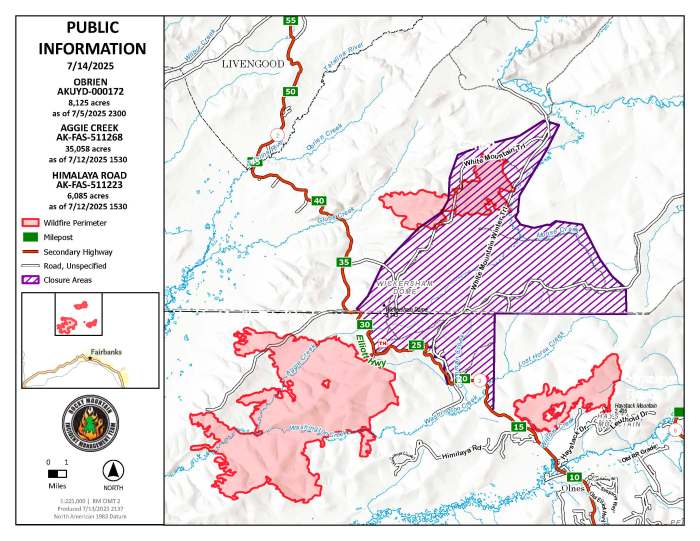
Aggie Creek Fire (#268): 35,038 acres, 2% contained
Himalaya Road Fire (#223): 6,055 acres, 12% contained
Obrien Fire (#172): 8,125 acres, 0% contained
Today, Rocky Mountain Area Complex Incident Incident Management Team Two (RM CIMT2) assumed command of the Aggie Creek Fire, Himalaya Road Fire, and Obrien Fire.
Operations: On the south side of the Aggie Creek Fire, the Chena Hotshots are seeking opportunities for direct and indirect line construction options toward Hayes Creek and assessing structures for protection needs along the Chatanika River. On the Obrien Fire, crews have completed structure protection efforts around BLM shelters and aviation resources are being utilized to keep heat in check along the southern end of the fire. On the north and south sides of the Himalaya Road Fire, crews continue to mop up and look for hot spots, while north of Caribou Creek, crews are monitoring areas of heat along the eastern end of the fire.
Weather: There is potential for a shot of moisture today, with a southwesterly flow bringing cloud cover and possible light showers expected over the northern fire area. Monday overnight into Tuesday is expected to bring stronger winds up to 25 miles per hour, diminishing Tuesday afternoon. Beyond Tuesday, a high-pressure system over the fire area will bring a warming and drying trend.
Smoke: For smoke outlook updates go to https://outlooks.airfire.org/outlook/e16e3fa2.
Closures: No road closures reported. Check https://511.alaska.gov/map for road conditions. Olnes Pond, the Whitefish Campground and the western portion of the White Mountains NRA are closed due to fire activity.
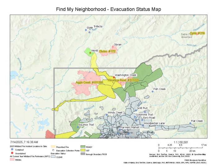
Evacuations: Level 1 “READY,” and Level 2 “SET,” evacuations are in effect for these fires. SET means be ready to evacuate on a moment’s notice. Visit https://bit.ly/FNSBevac for current evacuation levels.
Safety: Drivers must use extreme caution on Elliott Highway. Do not stop, be alert and watch out for firefighters working in the area. Smoke may limit visibility. A Temporary Flight Restriction is in place. Do not fly drones over the fire area. Unauthorized drone use poses serious risks to firefighter and public safety.
Categories: Active Wildland Fire, AK Fire Info, Alaska DNR - Division of Forestry (DOF)
