
Warmer temperatures are likely to reveal interior smoke, but fire activity is expected to be limited today on the Himalaya Road Fire (#223), Aggie Creek Fire (#268) and Obrien Fire (#172). Improved conditions allowed for landowners to access their property inside the Washington Creek fire footprint.
Numbers:
Aggie Creek Fire (#268): 35,146 acres, 2% contained
Himalaya Road Fire (#223): 6,194 acres, 12% contained
Obrien Fire (#172): 8,125 acres, 0% contained
Operations: On the Aggie Creek Fire, structure protection has been completed along the Chatanika River corridor, while mop up of residual heat continues along the Pipeline corridor in preparation to place it in patrol status. The Obrien Fire is in monitor status and will be patrolled by air resources. Fire near Eleazar’s cabin was suppressed with water drops from helicopters yesterday. To the northwest, structure assessments along the Elliott Highway corridor are complete and a protection plan is being developed. On the Himalaya Road Fire, fire managers are evaluating and aligning resources to meet current suppression needs. On the north and south sides of the Himalaya Road Fire, crews continue to mop up and look for hot spots. North of Caribou Creek, crews are monitoring areas of heat along the eastern end of the fire.
Weather: Today, skies will be partly cloudy and temperatures will be warmer with lower relative humidity and light northeast winds. On Friday, southwesterly winds will move into the area, bringing a 30% chance of thunderstorms.
Smoke: For smoke outlook updates go to https://outlooks.airfire.org/outlook/e16e3fa2.
Closures: No road closures reported. Check https://511.alaska.gov/map for road conditions. Olnes Pond, the Whitefish Campground and the western portion of the White Mountains NRA are closed due to fire activity.
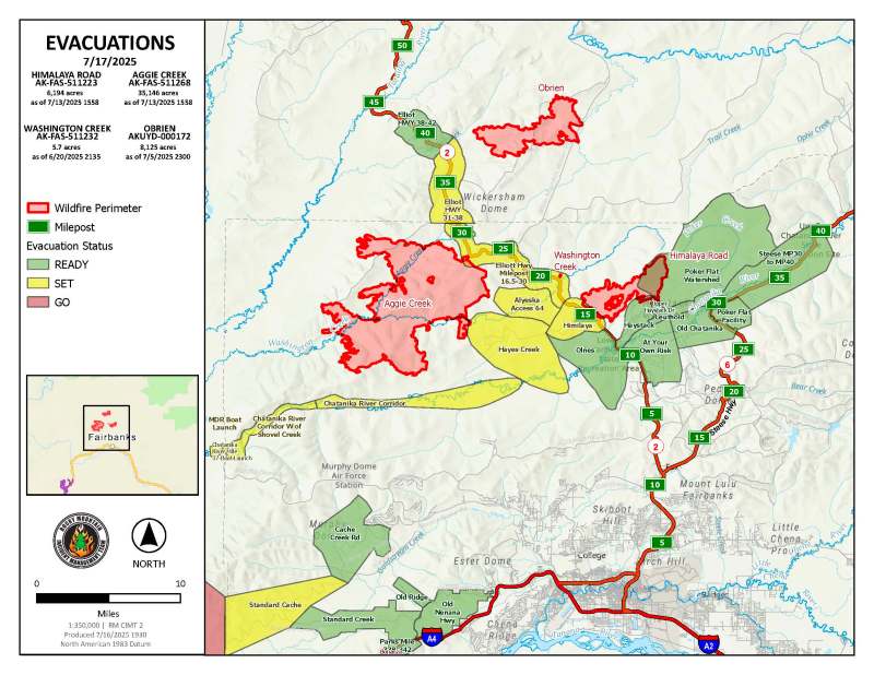
Evacuations: Level 1 “READY,” and Level 2 “SET,” evacuations are in effect for these fires. SET means be ready to evacuate on a moment’s notice. Visit https://bit.ly/FNSBevac for current evacuation levels.
Safety: Drivers must use extreme caution on Elliott Highway. Do not stop, be alert and watch out for firefighters working in the area. Smoke may limit visibility. A Temporary Flight Restriction is in place. Do not fly drones over the fire area. Unauthorized drone use poses serious risks to firefighter and public safety.
Categories: Active Wildland Fire, AK Fire Info, Alaska DNR - Division of Forestry (DOF)
