7 Mile Lookout Fire (#222)
Size: 3,969 acres Location: 7 miles southwest of Tok, AK
Start Date: June 19, 2025 Cause: Lightning Containment: 55% Total Personnel: 58
Evacuation levels for neighborhoods near the 7 Mile Lookout Fire (#222):
- READY (Level 1): Residents north of Butch Kuth Avenue and on Jack Wade Road.
- SET (Level 2): Residents on Osprey Road, Moose Nugget Road, and Goshawk Road.
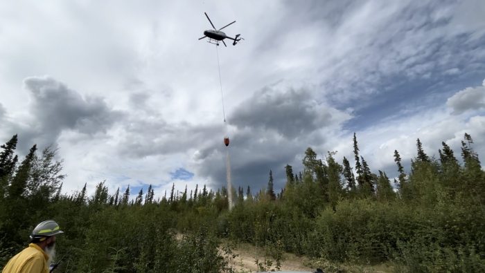
Activities: On Monday, Mat-Su and Tanana Chiefs handcrews laid approximately two miles of hose along the dozer line used as a control line just south of the Eagle Trail. This hose line will supply water access to ground crews working along the northern perimeter of the fire. Crews also continued mop up operations on the southern end of the fire in steep terrain. Fire behavior remained moderate due to cooler temperatures and persistent cloud cover. Light smoke remains visible in the interior and along the south edge of the fire area
Today, Mat-Su and Tanana Chiefs handcrews remain assigned to the incident. Crews will continue working in the areas of the fire where the most heat remains, particularly along the northeast and southeast edges. This includes saw work to remove logs and brush that could threaten containment lines, as well as mop up operations. Mop up involves extinguishing any remaining hot spots, turning over smoldering material, and cooling the area to prevent re-ignition and further spread. Three hotshot crews are expected to arrive by Tuesday evening to support ongoing fire suppression efforts, particularly along the northeastern and southeastern sections of the fire. These additional resources will aid in mop up operations in steep terrain and may be used for backburning, if necessary.
Weather: The forecast calls for mostly cloudy skies with west-northwest winds ranging from 10 to 20 mph, strongest in the afternoon and evening. Isolated rain showers are possible, with increasing chances of wetting rain by Wednesday night. Forecasters note low confidence in precipitation amounts due to the complex terrain within the fire area. Fire managers remain vigilant as fluctuating temperatures and dry conditions continue to pose a risk for fire activity until the area receives significant, sustained rainfall.
Aircraft and Drone Restrictions: A Temporary Flight Restriction (TFR) remains in effect over the fire area until further notice. The public is reminded not to fly any aircraft, including drones, near the fire. Unauthorized Unmanned Aircraft System (UAS) operations endanger aerial firefighting efforts and force suspension of air missions, which can allow wildfires to grow.
View the TFR details here: https://tfr.faa.gov/tfr3/?page=detail_5_1075
Click here for PDF of the update
Click here for the PDF of the map

Categories: Active Wildland Fire, AK Fire Info, Alaska DNR - Division of Forestry (DOF)
