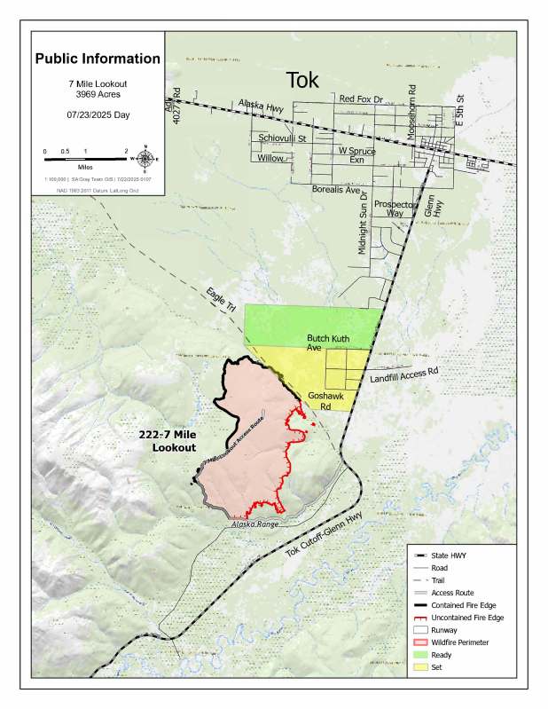
7 Mile Lookout Fire (#222)
Size: 3,969 acres Location: 7 miles southwest of Tok, AK
Start Date: June 19, 2025 Cause: Lightning Containment: 55% Total Personnel: 108
Evacuation levels for neighborhoods near the 7 Mile Lookout Fire (#222):
- READY (Level 1): Residents north of Butch Kuth Avenue and on Jack Wade Road.
- SET (Level 2): Residents on Osprey Road, Moose Nugget Road, and Goshawk Road.

Activities: On Tuesday, the Mat-Su and Tanana Chiefs handcrews continued work to cool down hot spots along the southeastern edge of the wildfire. Crews operated in steep, difficult terrain, but fire activity remained moderate thanks to cooler temperatures and cloud cover. Three additional handcrews, Gannett Glacier, Pioneer Peak and Silver City, arrived to assist and began assessing the fire area to better support suppression efforts.
Today, firefighters plan to start clearing vegetation along the 7 Mile Lookout Road and a bulldozer control line just south of the Eagle Trail. Work includes cutting and clearing downed logs and brush that could compromise control lines. If weather conditions are favorable in the next few days, fire managers may conduct a burn out to remove brush and dead wood between the wildfire and the control lines to protect homes and infrastructure. Additional hand crews have been requested to support the ongoing suppression operations.
Weather: Cool, wet conditions are expected to continue Wednesday and Thursday as a low-pressure system moves from the Interior toward the Gulf of Alaska. Temperatures will remain in the low 60s until a warming trend begins Friday. Northwest winds are forecast to be 14 mph and could reach 25 mph on ridge tops.
Aircraft and Drone Restrictions: A Temporary Flight Restriction (TFR) remains in effect over the fire area until further notice. The public is reminded not to fly any aircraft, including drones, near the fire. Unauthorized Unmanned Aircraft System (UAS) operations endanger aerial firefighting efforts and force suspension of air missions, which can allow wildfires to grow.
View the TFR details here: https://tfr.faa.gov/tfr3/?page=detail_5_1075
Remember: If you fly, we can’t.
Click here for the update in PDF
Categories: Active Wildland Fire, AK Fire Info, Alaska DNR - Division of Forestry (DOF)
