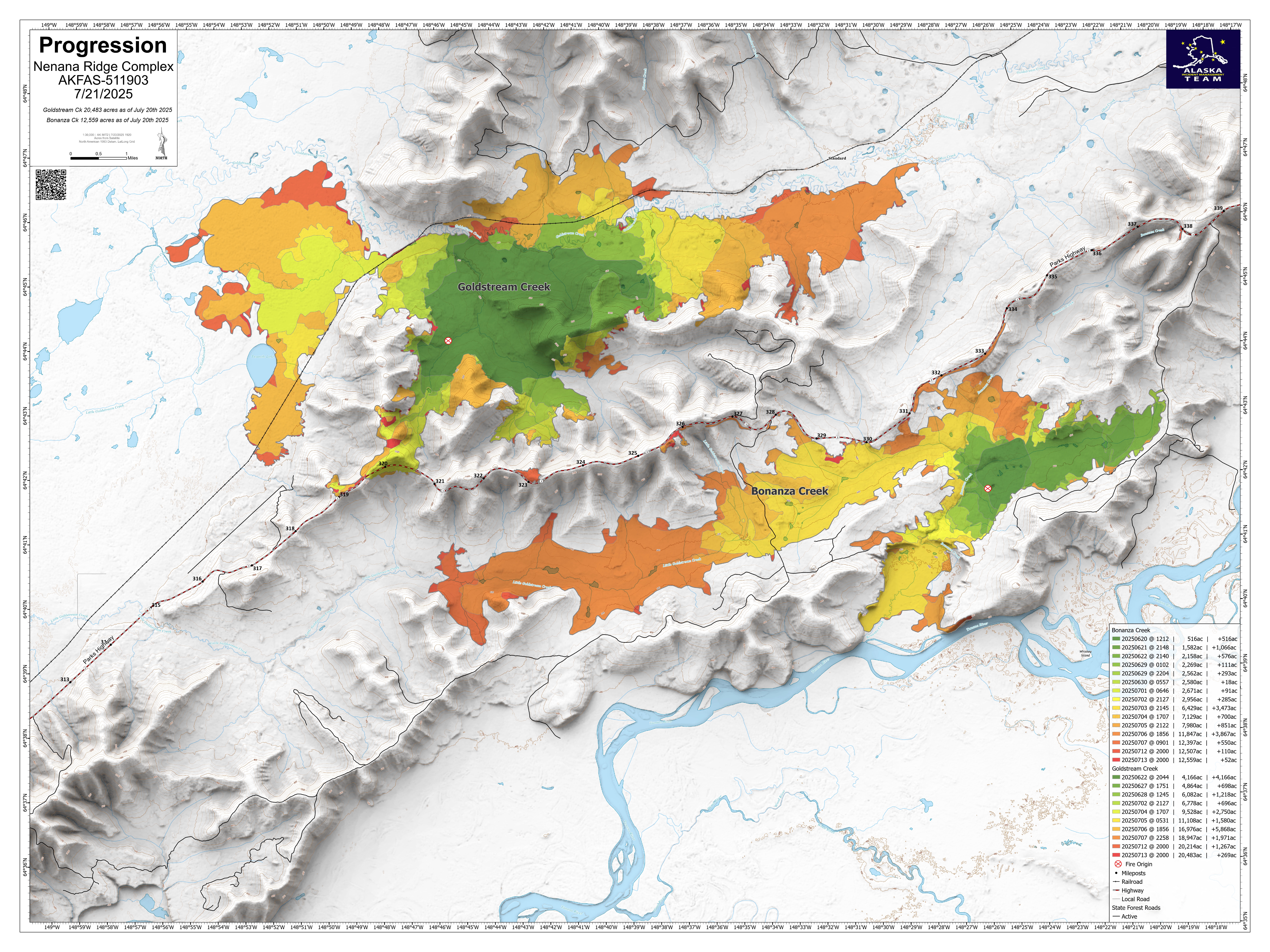
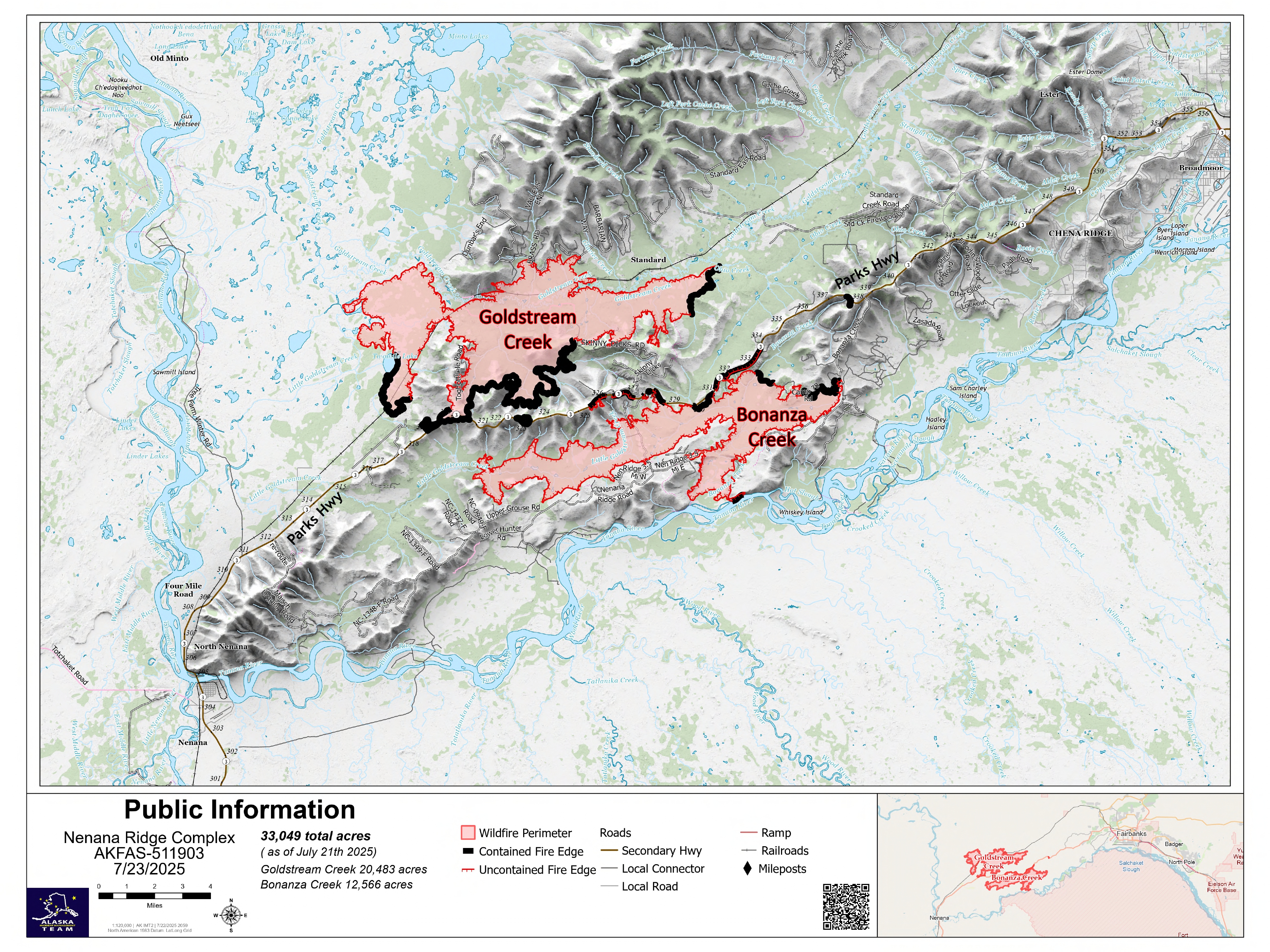
Bonanza Creek Fire (#238): 12,566 acres, 15% containment
Goldstream Creek Fire (#270): 20,483 acres, 41% containment
Personnel: 363

Evacuation Information: Evacuation levels were downgraded Monday, July 21st by the Fairbanks North Star Borough and the Alaska Division of Homeland Security and Emergency Management along the Parks Highway corridor.
🔴 Level 3 ‘GO!’:
- Outside the Borough: From the borough’s western edge, 4.5 miles west; from Sled Road north for 7 miles from the Alaska Railroad. This includes Standard Creek Road and nearby timber harvest access areas. The areas more than ½ mile west of the highway corridor from MP 317 to the borough boundary. The areas more than ½ mile east of the highway corridor from MP 312 to the borough boundary and to the Tanana River east of the Maich Logging Rd.
- Inside the Borough: Zones include Skinny Dick’s Logging Road, Nenana Ridge Forestry Road and Bonanza Creek Forestry Area.
🟡 Level 2 ‘SET’:
- Outside the Borough: Residents within ½ mile on each side of the highway from MP 317 north to the borough boundary.
- Inside the Borough: Residents with ½ mile on each side of the highway from the borough boundary to north MP 338. The Standard Cache zone that includes the middle portion of Standard Creek Road and the beginning of Cache Creek Road.
🟢 Level 1 ‘READY’:
- Outside the Borough: Parks Highway MP 308-317 extending west of the highway to include homes along Little Goldstream Road, agricultural areas, and the Alaska Railroad. Extending east of the highway to include homes and agricultural areas west of the Maich Logging Rd, including Farmview Subdivision.
- Inside the Borough: Evacuation zones Parks Mile 338-342, Old Nenana Highway, Standard Creek, Old Ridge Trail, and Cache Creek Road.

Fire Weather: Thursday will be mostly cloudy with a few showers possible. Cool conditions will continue with temperatures falling between 58-65 degrees. Relative humidities will be in the 50-60% range. Winds are predicted to be northeast in the morning and then switching to northwest later in the day.
Fire Update: Weather conditions were cool and moist on Wednesday. Intermittent showers over the past few days continue to keep fire behavior low. Within the fire perimeter there is a thick layer of organic material or duff that is holding heat despite the precipitation the fire has received. More precipitation is needed to completely put the fire out. Extinguishing these duff areas will be a main priority as crews continue to work the fire.
More containment line has been established around the fire. The Nenana Ridge Complex is currently at 33,049 acres with 28% containment. On the fire map the black lines designate where the fire has been called contained. These sections of the fire are only designated in containment status when firefighters are confident that there is no possibility of escaping the perimeter.
Along the Parks Highway, a road construction project unrelated to the fires is causing some delays. There is currently no implemented traffic control operation that is going on in relation to the Nenana Ridge Complex but there are still firefighters accessing the fire from along the highway. Drivers are asked to take caution when passing through these areas.
Work continues on the Goldstream Creek Fire. The southernmost portion is anticipated to be put into containment status in the following days. The northwestern side of the Goldstream Creek Fire is surrounded by wetland area. It has not seen significant fire movement and needs limited suppression action. Crews continue to work above Skinny Dick’s where there is an active timber sale. The objective is to preserve the section and the materials by strengthening containment around the plot. Pike Hotshots and Platte Canyon Suppression Module sought out and worked on hotspots in the northeast division of Goldstream with the support of infrared drone mapping. It is expected that this area will go into monitor status within the following days.
The mastication operations on the western side of the Bonanza Creek Fire resumed Wednesday as access road conditions improved. On northern sections of Bonanza, there are a significant amount of fire weakened trees also known as snags. Crews are working on felling and bucking these snags which hold heat and pose a hazard for firefighters as they work in the area.
Heavy equipment, hazard trees, ash pits and motor vehicles are all potential hazards. As hunting season approaches, hunters and recreators are asked to stay out of the fire areas due to safety concerns, threats to public and firefighter safety. Crews are still actively engaged in fire suppression operations.
No Drone Zone: Flying drones near wildfires is illegal and extremely dangerous, often leading to the grounding of firefighting aircraft and potentially causing harm to firefighters and property. A Temporary Flight Restriction (TFR) is in place over the Nenana Ridge Complex. For more information go to https://tfr.faa.gov
Road Safety: As you drive the Parks Highway, you may not see much firefighting activity, but crews are working deeper in the fire area and are still accessing these areas via the highway. Please use extra caution and watch for firefighters and equipment, especially between MP 318 to 340. Pilot car operations are taking place through an active construction zone unrelated to fire activities. For more information about this construction project go to: https://dot.alaska.gov/nreg/parks319to325/. For real-time road updates, visit 511.alaska.gov.
Click the image for a downloadable PDF map of the Nenana Ridge Complex.
More Information: For official updates, visit Alaska Wildland Fire Information at facebook.com/AK.Forestry.
For a PDF version of this update click here.
For the interactive Alaska Wildland Fire Information Map Series go here: https://arcg.is/1a0yT03
For video briefings and more fire-related content from the Alaska Division of Forestry & Fire Protection, visit our YouTube channel: https://www.youtube.com/@AlaskaDNRDOF
Public Information Line: (907) 331-0454
Email: 2025.nenanaridgecomplex@firenet.gov
Categories: Active Wildland Fire, AK Fire Info, Alaska DNR - Division of Forestry (DOF)
