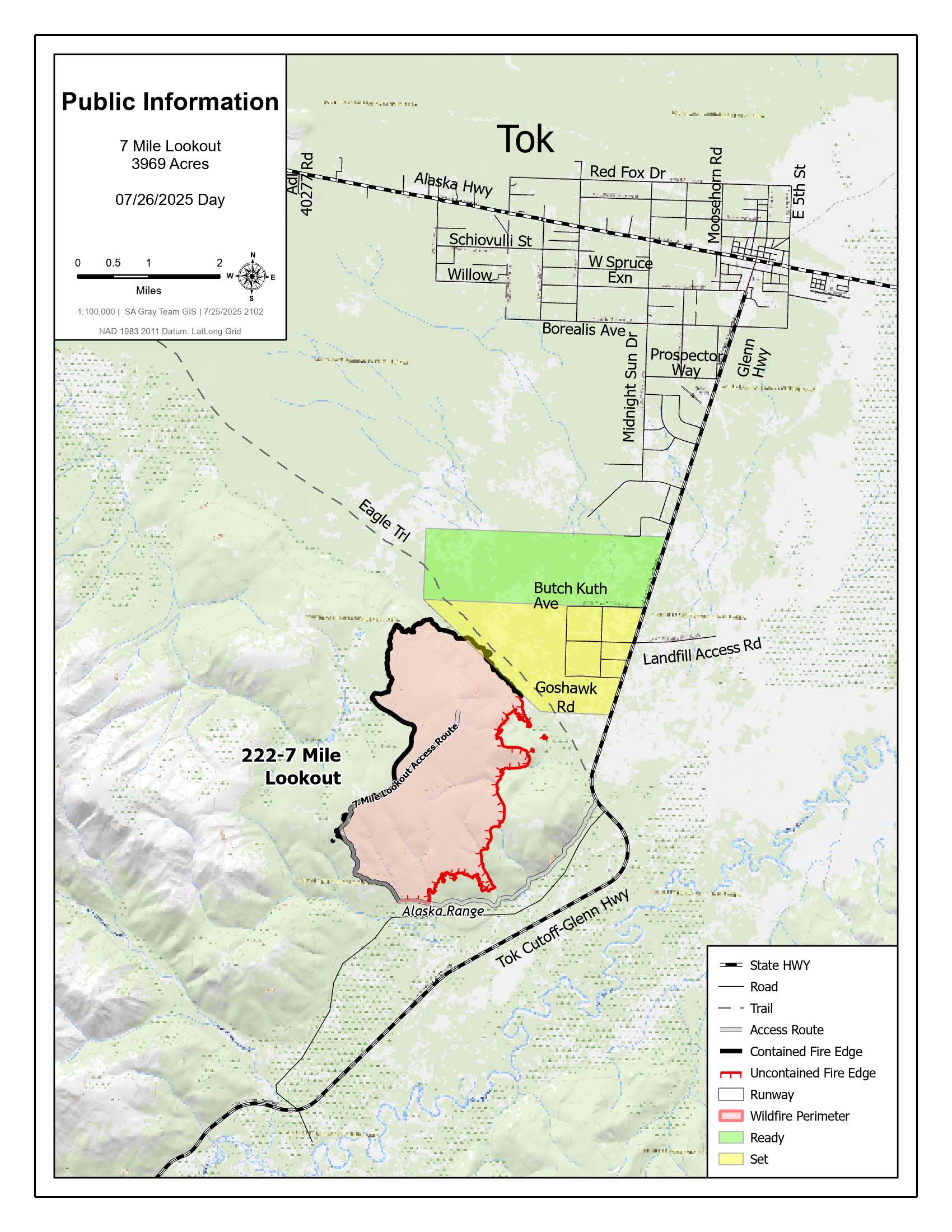
Size: 3,969 acres Location: 7 miles southwest of Tok, AK
Start Date: June 19, 2025 Cause: Lightning Containment: 55% Total Personnel: 113
Evacuation levels for neighborhoods near the 7 Mile Lookout Fire (#222):
- READY (Level 1): Residents north of Butch Kuth Avenue and on Jack Wade Road.
- SET (Level 2): Residents on Osprey Road, Moose Nugget Road, and Goshawk Road.

Activities: On Friday, firefighters reinforced control lines around the 7 Mile Lookout Fire in preparation for favorable weather conditions that could allow a burnout, or “backburn,” operation. Crews used chainsaws extensively along the 7 Mile Lookout Access Road and cleared brush along a bulldozer line south of the Eagle Trail to support the operation. Fire crews laid additional hose along the control lines to ensure they have a reliable water supply to hold and manage the burnout operation.
Today, fire crews will complete final preparations for the planned burnout operation. If weather conditions allow, fire managers could proceed with the full burnout operation as early as Sunday. Then fire managers plan to ignite vegetation between the 7 Mile Lookout Access Road and the bulldozer line south of Eagle Trail and the fire’s edge. This strategic burnout operation will allow fire managers to guide the fire safely down to established control lines, rather than risk unpredictable flare-ups from heat pockets. By directing the fire’s movement, crews can maintain control and reduce the threat to nearby communities. Once the burn is complete, firefighters will continue mop up operations.
If the burnout goes forward, smoke will likely be visible from Tok and along the Tok Cutoff of the Glenn Highway. Drivers should monitor current road conditions and possible travel delays at 511.alaska.gov.

Weather: Partly sunny with scattered showers. Warmer temperatures continue into the 70s with light winds.
Aircraft and Drone Restrictions: A Temporary Flight Restriction (TFR) remains in effect over the fire area until further notice. The public is reminded not to fly any aircraft, including drones, near the fire. View the TFR details here: https://tfr.faa.gov/tfr3/?page=detail_5_1075
Remember: If you fly, we can’t.
Click here for update of the PDF

Categories: Active Wildland Fire, AK Fire Info, Alaska DNR - Division of Forestry (DOF)
