
Southwest 6, a crew sponsored out of McGrath Alaska, smiling while in a Nodwell vehicle before mobilizing to the fire line. 📸 Nikos Kilcher/DOF, July 27 2025
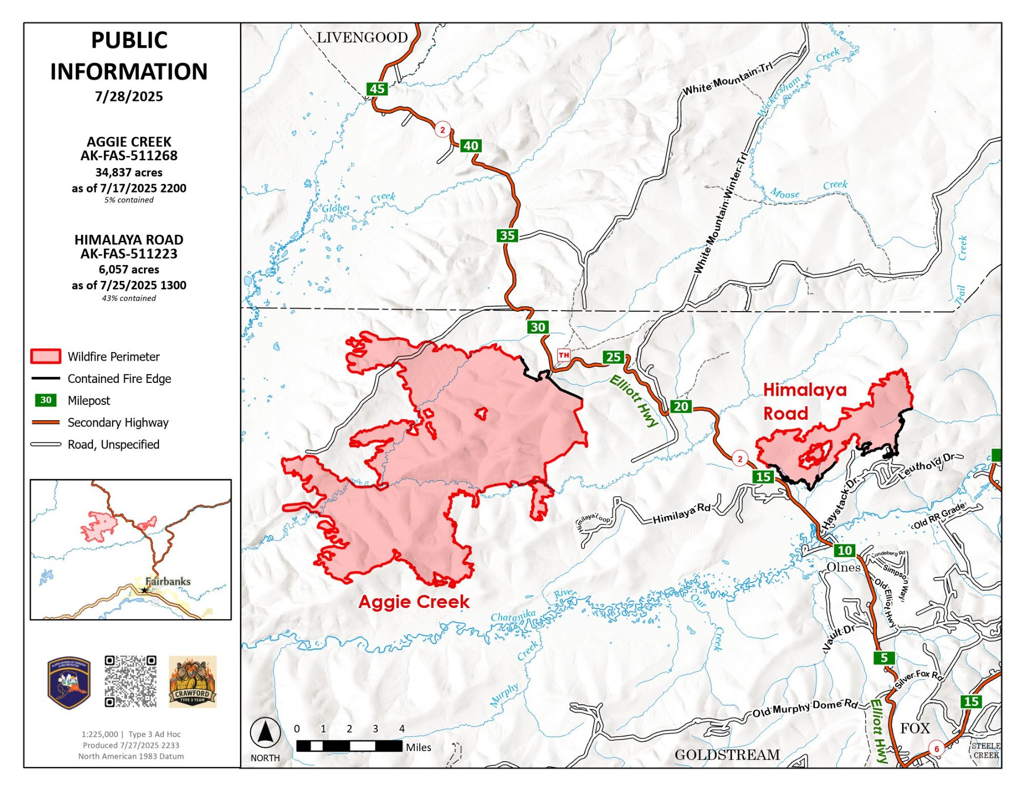
Warm and dry conditions throughout the weekend saw an increase of smoke from the Aggie Creek Fire (#243), however, all smoke and heat were located to be coming from the interior of the fire perimeter, surrounded by hardwood fuel types, and is not threatening any infrastructure. Firefighters on the Himalaya Road Fire (#223) worked together with excavators to continue to dig through berms looking for residual hot spots. The previously contained section of the Himalaya Road Fire was confirmed to have successfully held the fire throughout the warm weather this past weekend. The Whitefish and Olnes Campgrounds are still closed to the public.
Numbers:
Aggie Creek Fire (#268): 34,837 acres, 5% contained
Himalaya Road Fire (#223): 6,057 acres, 43% contained
Operations: Unmanned Aerial Systems (UAS) will be used today to locate ash pits and heat sources on the Himalaya Road Fire, which firefighters observed yesterday. The UAS will confirm the location of the heat sources and determine whether it is a concern or if it is deep enough in the interior to continue to smolder. Additional equipment is being backhauled on the Aggie Creek Fire. Crews on both fires continue to patrol and monitor the perimeter of the burn. Dozer berms that were previously created are being pulled apart to repair areas impacted by heavy equipment.
Weather: Chance of showers and thunderstorms increases as the week continues, with a 35-45% chance of rain today and 85-95% tomorrow. Fire activity is expected to be low, and no additional fire growth is expected currently.
Smoke: For smoke outlook updates, go to https://outlooks.airfire.org/outlook/e16e3fa2.
Closures: Check https://511.alaska.gov/map for road conditions. Olnes Pond and the Whitefish Campground remain closed to the public for use by the fire crews. Visit https://bit.ly/FNSBevac for current evacuation levels.
Evacuations: Level 1 “READY,” evacuations are still in effect. Level 1indicates that a fire is present in the area and to prepare for potential evacuation.

Safety: Drivers must use caution on Elliott Highway. A Temporary Flight Restriction is in place. Do not fly drones over the fire area. Unauthorized drone use poses serious risks to firefighter and public safety – If you fly, we can’t.
Phone Number: 907-921-7881
Website: https://akfireinfo.com/ Email: 2025.himalayaroad@firenet.gov
Categories: Active Wildland Fire, AK Fire Info, Alaska DNR - Division of Forestry (DOF)
