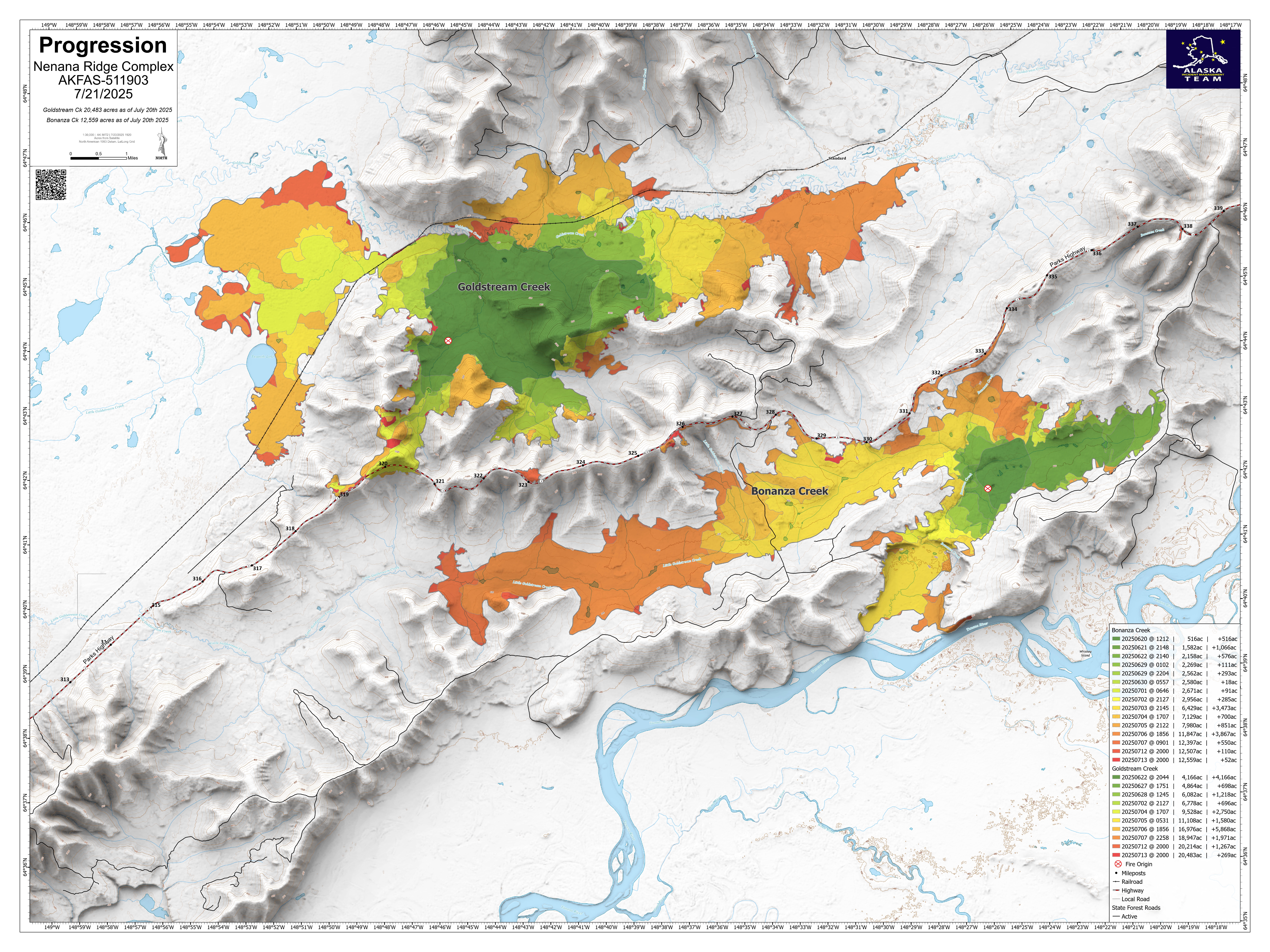
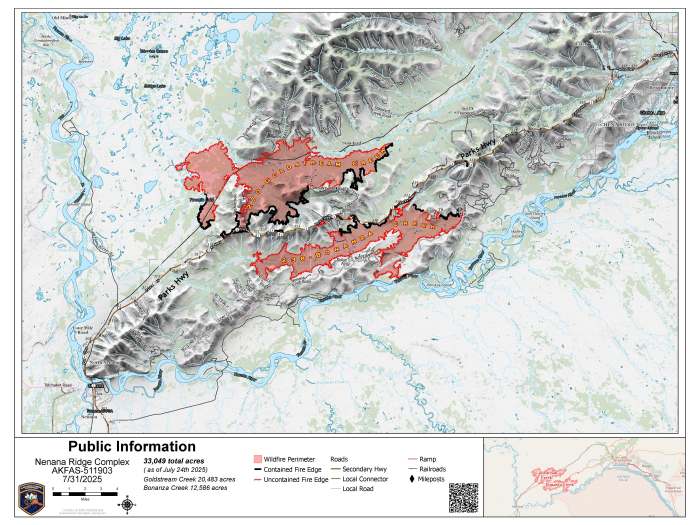
Bonanza Creek Fire (#238): 12,586 acres, 22% containment
Goldstream Creek Fire (#270): 20,483 acres, 42% containment
Personnel: 254
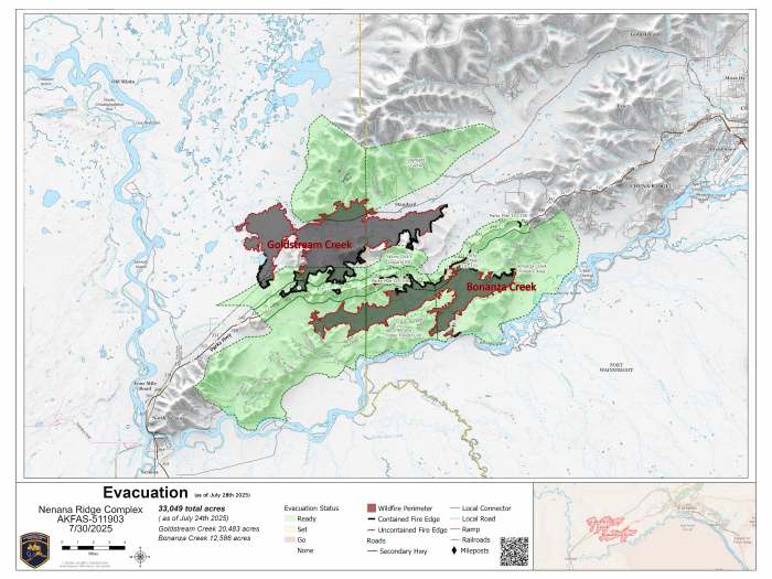
Evacuation Information: All evacuation levels were downgraded Monday, July 28th by the Fairbanks North Star Borough and the Alaska Division of Homeland Security and Emergency Management for the Nenana Ridge Complex.
🟢 Level 1 ‘READY’:
- Inside the borough:
- Zones include Standard Cache, Skinny Dick’s Logging Road, Parks Highway MP 325- MP 338, Bonanza Creek Forestry Area and Nenana Ridge Forestry Road.
- Outside the Borough:
- From the borough’s western edge, 4.5 miles west; from Sled Road north for 7 miles from the Alaska Railroad. This includes Standard Creek Road and nearby timber harvest access areas. The areas west of the highway corridor from MP 317 to the borough boundary.
- The areas east of the highway corridor from MP 311 to the borough boundary and to the Tanana River east of the Maich Logging Rd.
The areas east of the highway corridor from MP 311 to the borough boundary and to the Tanana River east of the Maich Logging Rd.
Fire Weather: Thursday will be partly sunny with isolated rain showers in the morning. The maximum temperature will be around 67 degrees with 47% relative humidity. Winds will be light in the valleys. Winds at the ridge tops will be out of the west at 5 to 10 mph
Fire Update: The Nenana Municipal Airport received 1.16 inches of rain in 24 hours as of late afternoon, Wednesday. The Nenana Ridge complex received varying amounts of precipitation throughout the fire. Fireline conditions were wet and muddy. Engines monitored and patrolled along the Parks Highway corridor. Personnel worked on snagging out sections of jackstraw off the corridor. Fairbanks 1 Type 2 Crew mopped up and extinguished hot spots in dozer berms on Bonanza Creek Road. Heavy equipment bosses assessed repair work throughout the complex, including the Little Goldstream Community. Repair work will begin when areas dry enough for equipment to access.
Heavy equipment, hazard trees, ash pits, and highway traffic remain potential hazards. As hunting season approaches, hunters and recreators are asked to stay out of the fire areas due to ongoing safety concerns. Crews are still actively engaged in firefighting operations.
No Drone Zone: Flying drones near wildfires is illegal and extremely dangerous, often leading to the grounding of firefighting aircraft and potentially causing harm to firefighters and property. A Temporary Flight Restriction (TFR) is in place over the Nenana Ridge Complex. For more information go to https://tfr.faa.gov
Road Safety: As you drive the Parks Highway, you may not see much firefighting activity, but crews are working deeper in the fire area and are still accessing these areas via the highway. Please use extra caution and watch for firefighters and equipment, especially between MP 318 to 340. Pilot car operations are taking place through an active construction zone unrelated to fire activities. For more information about this construction project go to: https://dot.alaska.gov/nreg/parks319to325/. For real-time road updates, visit 511.alaska.gov.
Click the image for a downloadable PDF map of the Nenana Ridge Complex.
More Information: For official updates, visit Alaska Wildland Fire Information at facebook.com/AK.Forestry.
For a PDF version of this update click here.
For the interactive Alaska Wildland Fire Information Map Series go here: https://arcg.is/1a0yT03
For video briefings and more fire-related content from the Alaska Division of Forestry & Fire Protection, visit our YouTube channel: https://www.youtube.com/@AlaskaDNRDOF
Public Information Line: (907) 331-0454
Email: 2025.nenanaridgecomplex@firenet.gov
Categories: Active Wildland Fire, AK Fire Info, Alaska DNR - Division of Forestry (DOF)
