Firefighters battling multiple lightning-caused fires in Southwest Alaska are finally getting a helping hand from Mother Nature in the form of cooler, wetter weather.
Several fires have received varying amounts of precipitation and temperatures cooled considerably on Thursday night and Friday as a weather system moved in from the Bering Sea. The rain, higher relative humidity and cooler temperatures have moderated fire activity on several fires burning in the area. The cooler, wetter weather is expected to persist into early next week.
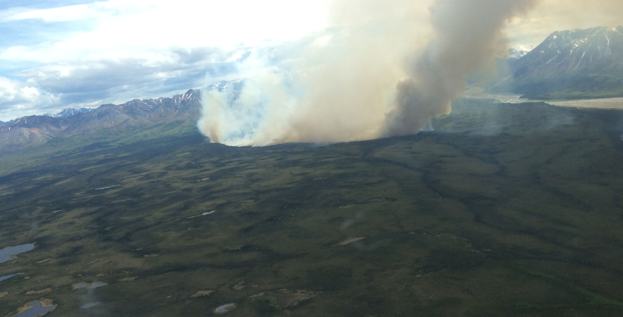
The Pitka Fork Fire burning 60 miles east of McGrath puts up smoke on Tuesday, June 6, 2017. Matt Snyder/Alaska DNR-Division of Forestry
As of Friday morning, there were 15 active fires that had burned more than 44,000 acres in the Alaska Division of Forestry’s Southwest Area, which encompasses 88 million acres from McGrath to Dillingham. Seven fires are burning in full/modified protection areas and there are eight fires burning in limited protection areas. Seven fires are being staffed and the remainder are being monitored.
Here is a rundown of fire activity in Southwest Alaska:
Staffed Fires
- Bell Creek Fire (#161), 2,675 acres – The highest priority fire currently in Southwest Alaska. It is burning within two miles of the village of Crooked Creek on the Kuskokwim River, approximately 110 miles southwest of McGrath. The fire is backing down a ridge toward the village. Firefighters have constructed an indirect line and set up protection for structures on the north end of the town closest to the fire with pumps, hoses and sprinklers in anticipation of the fire encroaching the village. There are 61 personnel working on the fire. The fire received light precipitation overnight Thursday. Crews today will continue structure protection measures and plan for a series of fold-a-tanks for water to be used for potential future initial attack. Crew will also assess allotments to the east end of town and allotments with structures across the Kuskokwim River.
- Pitka Fork Fire (#160), 4,030 acres – Burning 60 miles east of McGrath. The fire was extremely active Thursday with torching, spotting and running. The Gannett Glacier Type 2 Initial Attack Crew was flown to the fire on Thursday to secure cabins on the Windy River and complete mop up from a burnout operation conducted by smokejumpers. The Upper Kalskag Type 2 Crew is worked on securing cabins and structures on East Lakes, in addition to mopping up from Wednesday’s burnout operation. Smokejumpers on Thursday conducted burnouts on structures on the North Island. Gannett Glacier will continue securing cabins on Windy River today while the Upper Kalskag crew mops up and secures the North Island cabins. Smokejumpers will evaluate multiple structures along Sheep Creek and the Farewell airstrip. There are 38 personnel working on the fire.
- Ball Creek Fire (#164), 8,462 acres – Burning in a full protection area approximately 75 miles southwest of McGrath and eight miles west of the historical mining site of Flat. The fire was flown Wednesday evening and the perimeter was 75% active with 2- to 4-foot flame lengths and pockets of 30-foot flame lengths. The fire is creeping, running and torching down slope in black spruce, tundra and mixed hardwoods. Three personnel were inserted Friday to evaluate possible structure protection in the area of Flat. No resources are immediately threatened.
- Spruce Creek Fire (#155), 42 acres – Burning approximately 30 miles west of McGrath. The Nikolai Type 2 Crew continues to work around the perimeter of the fire gridding and extinguishing hotspots. The crew is working 100 feet into the black and was about halfway around the fire at the end of shift Thursday. The crew will ill continue to grid 100′ into the black today with demobilization scheduled for Sunday. There are 18 personnel working on the fire.
- Brown Creek Fire (#157), 45 acres – Burning approximaely 35 miles west of McGrath. The Nondalton Type 2 Crew continued to grid the fire on Thursday, identifying several areas of heat. The crew will conduct a final grid of the fire today and demobilize in the evening. There are 17 personnel working on the fire.
- Black River Fire (#172), 8 acres – Burning 38 miles south of McGrath. There was no new growth on the fire on Thursday. The Lower Kalskag Type 2 Crew tied in the saw line around the fire, gridding in 50 feet around the perimeter. Twenty hotspots were discovered and extinguished. Due to heavy fuels, the crew will spend two more shifts gridding and mopping up before being demobilized this weekend. There are 22 personnel working on the fire.
- Sullivan Creek Fire (#163), 352 acres – Burning in a modified protection area approximately 45 miles east of McGrath. The fire was flown Thursday and no fire activity was observed after considerable precipitation overnight. Five initial attack personnel were inserted Friday to set up structure protection for a wooden bridge associated with the Iditarod Trail Sled Dog Race. Personnel will be demobilized Saturday morning. The increase in acreage from 100 acres was due to more accurate mapping.
Unstaffed fires
- Kenakuchuk Creek Fire (#146), 1,558 acres – Burning in limited protection approximately 60 miles north of Dillingham. The fire was flown on Wednesday and there was active smoke in some areas.
- Tubungaluk Creek Fire (#152), 640 acres – Burning in limited protection approximately 31 miles northeast of Bethel in the Yukon Delta National Wildlife Refuge. The fire was flown on Thursday and was reported at 640 acres, an increase of more than 350 acres. The perimeter was 5 percent active with 1- to 2-foot flames and backing to the west. The fire will continue to be monitored.
- Pikmiktalik River Fire (#154), 773 acres – Burning in limited protection approximately 27 miles northeast of Bethel in the Yukon Delta National Wildlife Refuge. The fire was flown on Thursday and reported to be 1 percent active, burning in tundra on the north and south sides with 1-foot flames in discontinuous fuels in wetlands. The increase in acreage from 430 acres was due to more accurate mapping. The fire will continue to be monitored.
- American Creek Fire (#158), 11,498 acres – Burning in limited protection approximately 42 miles west of McGrath. The fire was flown on Friday and is burning in black spruce, tundra and mixed hardwoods with a 25 percent active perimeter. Flame lengths were 1 to 4 feet with pockets of 25-foot flame lengths. There was some additional growth to the south and west but no movement to the east where there are cabins on the Innoko River, about 4 miles away. The fire will continue to be monitored.
- Little Yetna River Fire (#159), 12,315 acres – Burning in limited protection approximately 100 miles southwest of McGrath. The fire was flown on Friday and the perimeter was 5 percent active with creeping and smoldering on the south side. Nothing is threatened and the fire will continue to be monitored.
- Paiyun Creek Fire (#174), 600 acres – Burning in limited protection approximately 50 miles southeast of Bethel in the Yukon Delta National Wildlife Refuge. The fire was not flown on Thursday and the acreage was updated to match the digital perimeter. There are some allotments in the area but nothing is immediately threatened.
- Coral Creek Fire (#200), 500 acres – The fire was reported on June 7 in limited protection about 245 miles southwest of McGrath in the Yukon Delta National Wildlife Refuge. The fire was not flown on Thursday and remains in monitor status.
Categories: Active Wildland Fire, AK Fire Info
