Fire growth on the Swan Lake Fire burning in the Kenai National Wildlife Refuge was moderated by the cloud cover n Monday. Limited expansion occurred in the areas mostly to the north and northwest where the black spruce stands remain receptive to fire growth. The fire area remains at an estimated 12,782 acres according to the Alaska Division of Forestry.
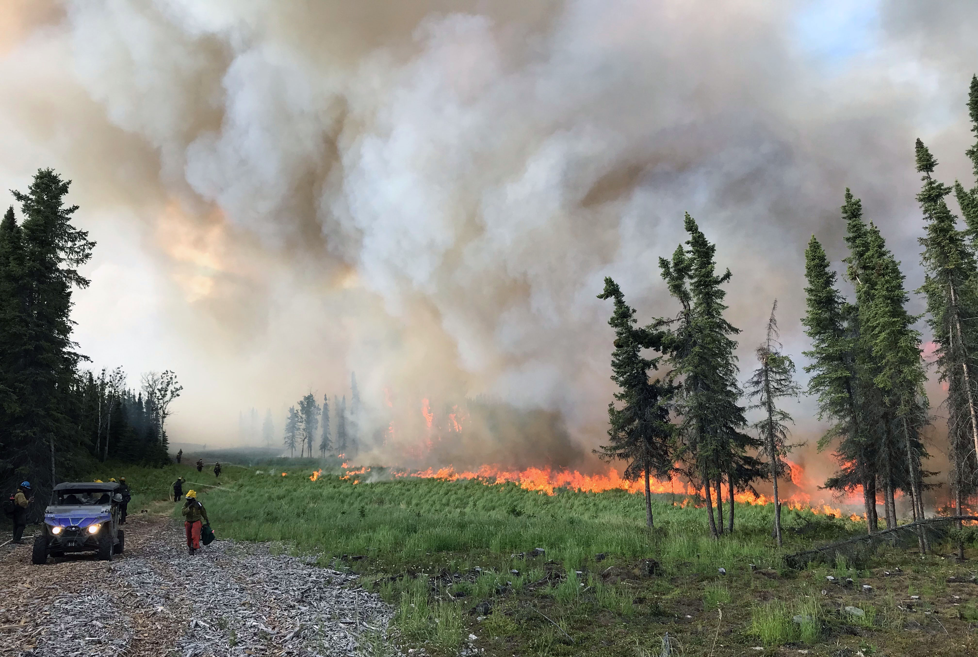
The Pioneer Peak Interagency Hotshot Crew conducts a strategic burn operation on the southwest edge of the Swan Lake Fire on Monday, June 17, 2019. The goal of the firing operation to secure and reinforce the primary control lines to the southwest to prevent fire spread toward the Sterling Highway. Photo by Pioneer Peak Interagency Hotshot Crew.
There was a smooth transition this morning to the Type 2 Alaska Interagency Incident Management Team under the leadership of Incident Commander Tom Kurth. The Type 2 team relieves initial attack forces who have been in place for the past eight days. Fire managers are also able to increase the staffing in each geographic area of the fire, expand aerial firefighting operations, and plan for the assessment and continued long term protection of the values at risk beyond the immediate fire area.
An additional hand crew was inserted into the southern control line closest to the Sterling Highway to provide further protection for all of the assets and infrastructure in the highway corridor. Crews used tactical firing operations to secure and reinforce the primary control lines to the southwest with the support of helicopters and small water-scooping aircraft known as Fire Bosses. The Pioneer Peak Interagency Hotshot crew initiated the firing operation on the west while the University of Alaska Nanooks Type 2 Wildland Fire Crew followed behind ensuring that any spot fires were immediately addressed. The Gannett Glacier Type 2 Initial Attack hand crew completed a successful burnout and point protection operation around the Enstar gas pipeline’s Thermoelectric Generator (TEG), which sits above ground east of the fire.
 Today, hand crews will continue to reinforce and defend the primary line on the west of the fire to prevent spread toward the community of Sterling. As conditions allow, crews will continue firing operations along the west and southern control lines in order to gain depth and prevent fire spread toward the infrastructure along the Sterling Highway corridor. While there is no immediate threat to the community of Sterling from the Swan Lake Fire, structure protection specialists will begin validating the readiness of private homes and businesses in the area. Homeowners are encouraged to remove brush and follow other Firewise best practices which may be found at firewise.org.
This natural, lightning-caused fire can restart the boreal forest’s succession and increase moose and wildlife habitat on a part of the landscape that has not seen fire since 1947. This fire helps reduce the risk of future fires threatening local communities when weather is less favorable by removing fuel now. Burn scars affect new fires for years, slowing their progress and giving firefighters more time to respond. For more information on Alaska’s forest succession and wildland fire on National Wildlife Refuges visit: https://tinyurl.com/y4hpul8x.
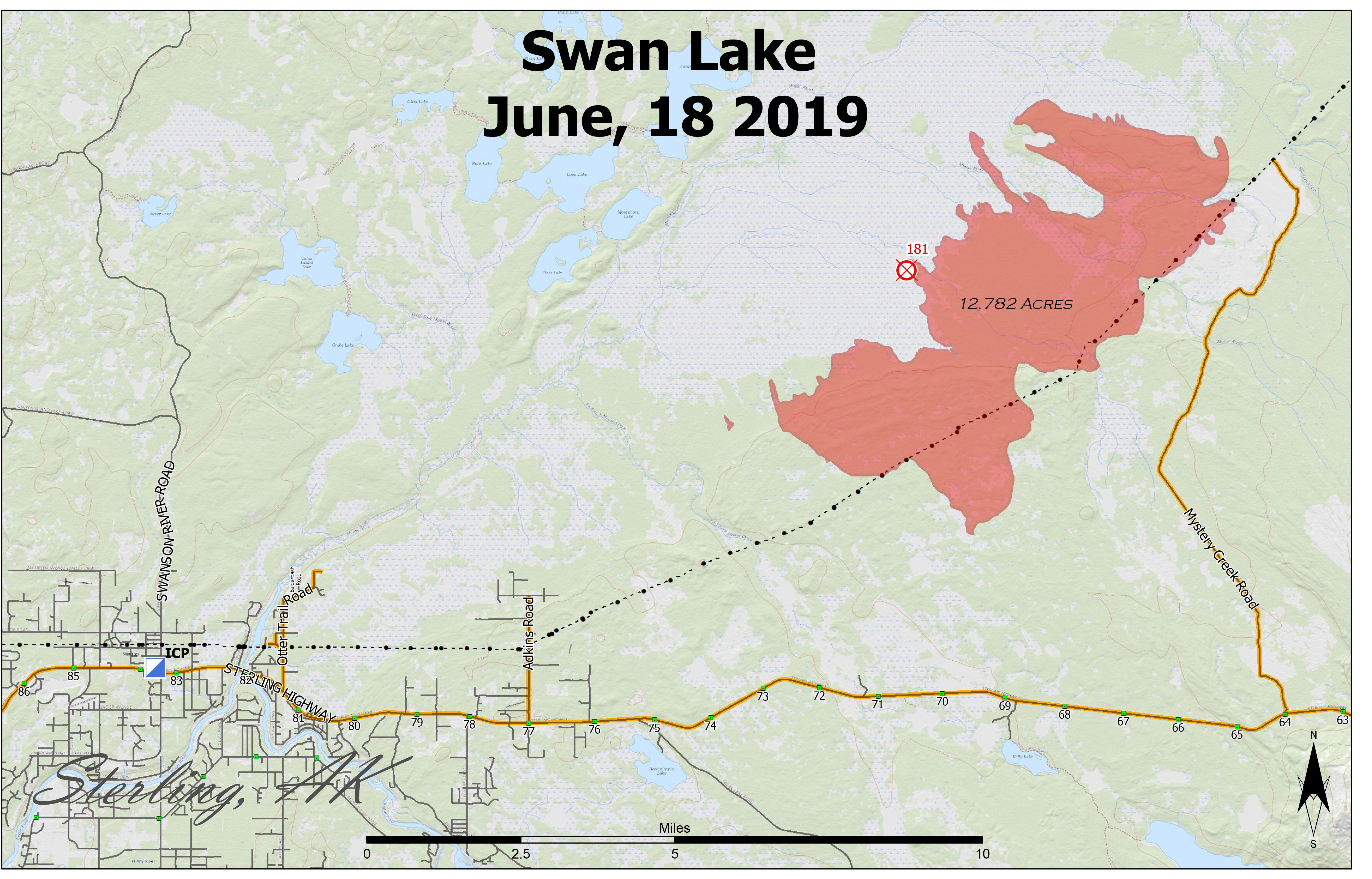
A map showing the perimeter of the 12,782-acre Swan Lake Fire as of June 18, 2019. For a downloadable PDF version of the map go to Swan Lake Fire PDF map June 18
OBJECTIVE: The fire is burning in a limited protection area within the Kenai National Wildlife Refuge. Fire managers with the Alaska Division of Forestry are working collaboratively with refuge personnel to manage the fire. The focus of all suppression efforts is to protect all of the values at risk including the community of Sterling and the Sterling Highway corridor while reducing future wildland fire hazards and enhancing wildlife habitat.
WEATHER: Winds are predicted to remain relatively calm today with northeast winds 3-5 mph shifting to southwest 4-7 mph in the afternoon. Light rain showers in the vicinity are possible, resulting in the possibility of continued cloud cover and shading for the fire area.
SAFETY: Motorists are urged to yield to fire apparatus entering the Sterling Highway and to adhere to traffic signage staged near miles 82 and 92. Observing the fire from a safe location should be practiced instead of stopping along the highway. For current road conditions visit http://511.alaska.gov. Supporting agencies are posting fire and smoke-related information, official updates and helpful links at www.kpboem.com. The Temporary Flight Restriction (TFR) has expanded in size today to support suppression efforts and firefighter safety. Pilots and drone operators can confirm the current TFR restrictions at tfr.faa.gov. Be advised that drone operation is not permitted on the refuge.
FIRE INFORMATION: Call Division of Forestry Public Information office at 208-391-3488, visit kpboem.com or inciweb.nwcg.gov/incident/6387/
Categories: Active Wildland Fire, AK Fire Info
