Widespread lightning has started at least 30 new fires since Thursday in the Alaska Division of Forestry’s Southwest Area around McGrath. A Red Flag Warning remained in effect for most of Southwest Area for more lightning on Friday and fire managers anticipate finding more new starts in coming days as a result of the recent lightning bust.
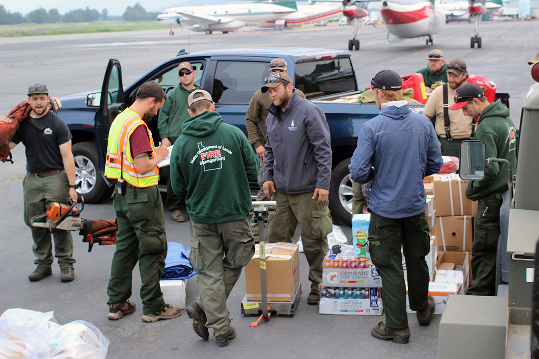
Members of an Idaho Department of Lands Fire Crew prepares to board a flight from Palmer to McGrath before being assigned to one of dozens of fires burning in Southwest Alaska around McGrath. Photo by Mike McMIllan/Alaska Division of Forestry.
Many of the new and existing fires in the Southwest Area are burning in limited protection areas and are not being fought because they do not pose a threat to life or property. Given the high number of fires in the area, fire managers are prioritizing firefighting resources for “point protection” to defend assorted values at risk, including villages, commercial and historical infrastructure, remote cabins and Native Alaskan allotments of land.
Widespread smoke is dissipating in many areas, bringing improved flying conditions for air tankers, water-dropping helicopters, smokejumpers, and logistical aircraft flying re-supply missions to firefighters working in remote locations.
Here’s a rundown of the new and existing fires in the Southwest Area as of 5 p.m. Friday:
- The Vreeland Creek Fire (#525) was started by lightning on July 12, 15 miles southwest of Red Devil. No additional information is available for the unstaffed fire.
- The East Stoney River Fire (#523) was started by lightning on July 12, four miles east of Stoney River. The unstaffed fire is burning in black spruce, hardwoods and tundra and is 40 acres in size. Smokejumpers and air tankers were ordered for the fire.
- The Tishimna Lake Fire (#521) was started by lightning on July 12, 25 miles northwest of Lime Village. The unstaffed fire is 10% active, burning in black spruce and tundra with several area cabins threatened. Smokejumpers have been ordered for the fire.
- The Devil’s Elbow Fire (#496) was started by lightning on July 11, 60 miles south of McGrath. The fire is burning in black spruce and hardwoods and is estimated to be 3,000 acres. Cabins, Native Alaskan allotments and a sawmill operation are threatened. Two helitack firefighters from McGrath are in place and working on structure protection at the cabins.
- The Holokuk River Fire (#510) was started by lightning on July 11, 50 miles southwest of Red Devil. The unstaffed fire is 325 acres in size and 10% active in black spruce. No known values are at risk and the fire will be monitored by air.
- The Holokik Mountain Fire (#511) was started by lightning on July 11, 25 miles south of Crooked Creek. The unstaffed fire is burning 25 acres of black spruce and tundra, within 2 miles of Native Alaskan allotments. The fire will be monitored by air.
- The Ethel Creek Fire (#516) was started by lightning on July 11, 60 miles northwest of Nondalton. The unstaffed fire is burning 48 acres in tundra, with Native Alaskan allotments f4 miles to the east. The fire will be monitored by air.
- The Spike Mountain Fire (#514) was started by lightning on July 11, 25 miles south of Red Devil. The unstaffed fire is burning 60 acres of black spruce and is 100% active. No known values are at risk, and the fire will be monitored by air.
- The Venturi Lake Fire (#518) was started by lightning on July 11, 15 miles east of Kokhanok and Lake Illiamna. The 20-acre fire will be monitored by air.
- The Discovery Creek Fire (#509) was started by lightning on July 11, 25 miles south of Aniak. The unstaffed fire is burning in black spruce, and the Faulkner Homestead is the closest value at risk. The fire will be monitored by air.
- The Beaver House Hill Fire (#501) was started by lightning on July 11, 18 miles southeast of Red Devil. The unstaffed fire is burning 5 acres in black spruce and threatening a Native Alaskan allotment. The fire will be monitored by air.
- The West Devils Elbow Fire (#504) was started by lightning on July 11, 20 miles northeast of Red Devil. The unstaffed fire is 20 acres in size, and no known values are at risk. The fire will be monitored by air.
- The Horn Foothills Fire (#506) was started by lightning on July 11. 20 miles southwest of Crooked Creek. The unstaffed fire is burning 600 acres and is 100% active in black spruce and tundra, with no known values at risk. The fire will be monitored by air.
- The Little Titnuk Fire (#513) was started by lightning on July 11, 18 miles southeast of Red Devil. The unstaffed fire is 600 acres in size and 100% active in black spruce, with no known values at risk. The fire will be monitored by air.
- The Door Mountains Fire (#517) was started by lightning on July 11, and is burning 30 miles southwest of Lime Village. The 1,000-acre fire is burning in black spruce with no known values at risk. The fire is unstaffed and will be monitored by air.
- The Molybdenum Mountains Fire (#507) was started by lightning on July 11, 15 miles northeast of Aniak. The unstaffed fire is 60 acres in size and 90% active in black spruce and tundra. No known values are at risk, and the fire will be monitored by air.
- The Taylor Mountain Fire (#515) was started by lightning on July 11, 60 miles south of Red Devil. The unstaffed fire is 100% active in 350 acres of black spruce, 5 miles south of the Taylor Mountains Mining Camp. The fire will be monitored by air.
- The Tundra Lake Fire (#474) was started by lightning on July 10 and is 50 miles northwest of Lake Clark National Park and Preserve, about 10 miles south of Lime Village. Eight smokejumpers are defending a cabin and Native Alaskan allotment near the fire, which is 200 acres in size and 90% active.
- The Hidden Creek Fire (#464) began on July 9 and is 20 miles northwest of Nikolai in the area of the Nixon Fork Gold Mine. Seven smokejumpers and 15 firefighters from McGrath are in place at the mine, setting up pumps, hoselays and sprinkler systems on area structures, which have not been impacted by the fire. The 300-acre fire is burning in mixed spruce and hardwoods, and the cause is under investigation.
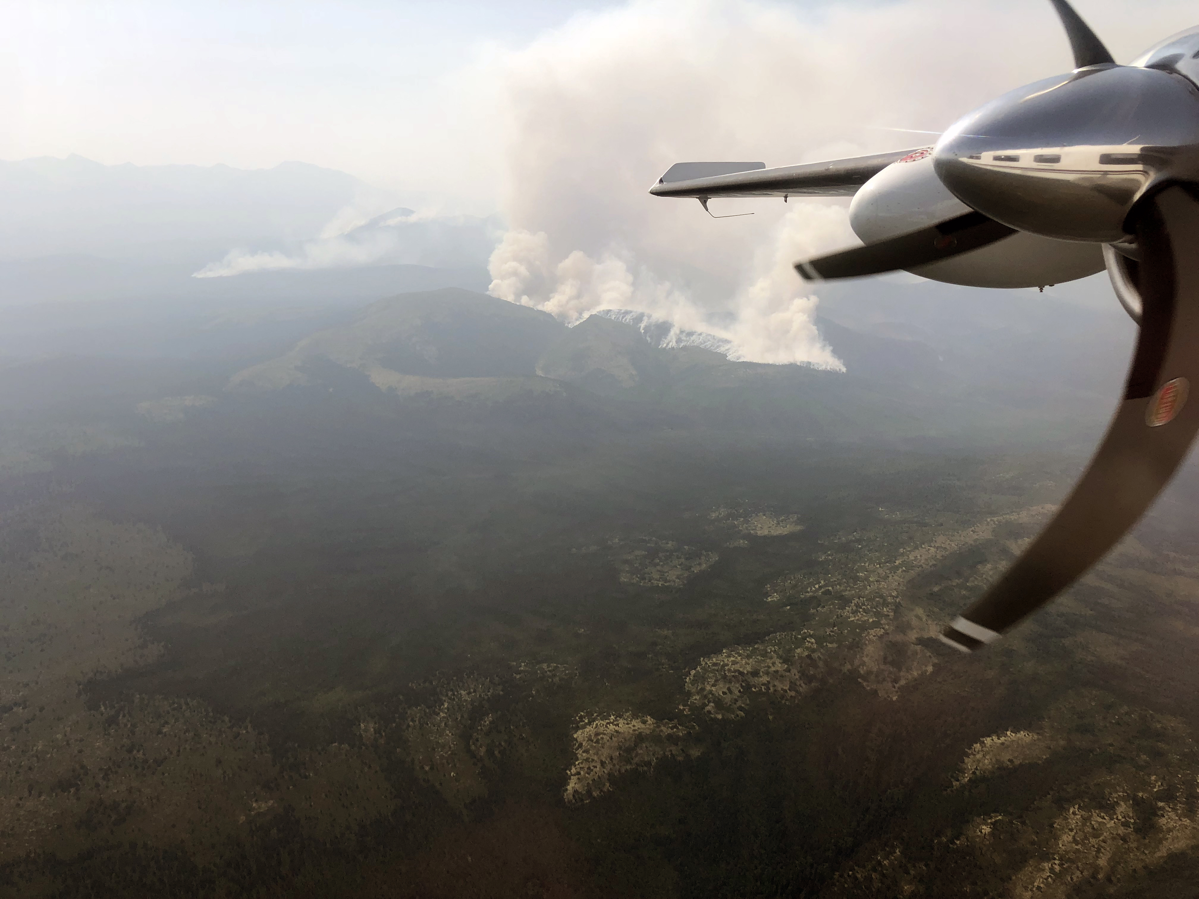
The Hurst Creek Fire as seen during a reconnaissance flight on Sunday, July 7, 2019. The fire has since been consumed by the Old Grouch Top Fire. Photo by Matt Snyder/Alaska Division of Forestry
- The Hurst Creek Fire (#352) was started by lightning on June 22 and has burned into the Old Grouch Top Fire (#174), another lightning-caused fire that started on June 5. Both fires are unstaffed and are now being managed as the Old Grouch Top Fire, about 35 miles northwest of McGrath. The Hurst Creek Fire burned 84,741 acres of mixed spruce, tundra and hardwoods while the Old Grouch Top Fire has burned 251,811 acres and is the largest fire in the state. The merged fire is being monitored by aircraft.
- The Snipe Lake Fire (#467) was started by lightning on July 9. The unstaffed fire is burning in tundra in the Lake Clark National Park and Preserve, and 20 acres in size. No known values are at risk, and the fire is being monitored by aircraft.
- The Pit Peak Fire (#481) is unstaffed and burning in black spruce, 35 miles south of Aniak, and 400 acres in size. No known values are at risk, and the fire is being monitored by aircraft.
- The Swift Creek Fire (#480) is unstaffed, burning in black spruce, 35 miles south of Aniak, and 150 acres in size. No known values are at risk, and the fire is being monitored by aircraft.
- The Chilchitna Headwaters Fire (#476) is unstaffed, burning in black spruce,12 miles northwest of Lake Clark National Park and Preserve, and 200 acres in size. No known values are at risk, and the fire is being monitored by aircraft.
- The Door Creek Fire (#475) was caused by lightning on July 10. The unstaffed fire is 15 miles southwest of Lime Village, burning in black spruce and tundra, 30 acres in size and 100% active. No known values are at risk, and the fire is being monitored by aircraft.
- The Stony River Flats Fire (#477) was caused by lightning on July 10. The unstaffed fire is 12 miles northwest of Lime Village, burning in black spruce and tundra, 40 acres in size and 80% active. There is a cabin approximately five miles from the fire with defensible space around it, and it is not threatened at this time, and the fire is being monitored by aircraft.
- The Upper Falls Fire (#479) was caused by lightning on July 10. The unstaffed fire is 12 miles north of the Togiak Wildlife Refuge, burning in tundra and brush,15 acres in size and 100% active. No known values are at risk, and the fire is being monitored by aircraft.
- The Quicksilver Creek Fire (#478) was caused by lightning on July 10. The unstaffed fire is 15 miles north of the Togiak Wildlife Refuge, burning in tundra and brush, 5 acres in size and 50% active. No known values are at risk, and the fire is being monitored by aircraft.
- The McCally Creek Fire (#487) was caused by lightning on July 10. Eight smokejumpers initially staffed the fire, before disengaging and relocating to Red Devil to protect the village. The fire is burning in tundra and black spruce, two miles southwest of Red Devil.
- The Barometer Mountain Fire (#491) was caused by lightning on July 10. Eight smokejumpers mobilized to the fire before relocating to Red Devil to protect the village. The fire is burning in tundra and black spruce, about one mile southwest of Red Devil.
- The Barometer Foothills Fire (#499) was started by lightning on July 11, within a mile southwest of Red Devil. The 30-acre fire is one of three fires in the area, and fire managers have ordered three 20-person fire crews to Red Devil to protect structures in the village.
- The Jump Peak Fire (#488) was caused by lightning on July 10. The unstaffed fire is smoldering in black spruce, less than an acre in size, approximately 7 miles northwest of Red Devil.
- The Fuller Creek Fire (#489) was caused by lightning on July 10. The unstaffed fire is burning in black spruce and tundra, 200 acres in size and 100% active, located approximately 10 miles west of Red Devil.
- The Kolmakof Hills Fire (#490) was caused by lightning on July 10. The unstaffed fire is burning in black spruce and tundra, less than an acre in size, located 25 miles east of Aniak.
- The Titnuk Creek Fire (#495) is unstaffed, smoldering in black spruce and tundra, 25 miles southeast of Red Devil, and 50 acres in size. No known values are at risk, and the fire is being monitored by aircraft.
- The Pete Andrews Creek Fire (#457) was reported July 8, 10 miles west of Illiamna. Air tankers dropped retardant on the 1,300-acre fire to slow its progress. The fire is being monitored by air.
Categories: Active Wildland Fire, AK Fire Info
