The Alaska Fire Service Interagency Type 3 Incident Management Team arrived on Sunday to shadow the current outgoing team and assumed command of the fire this morning at 7:00 a.m. There are currently 138 personnel assigned to the Ptarmigan Complex. Today, a weather shift will be occurring across the Alaska interior as the lingering high-pressure ridge begins to collapse.
An inversion has persisted for several days over the fire, moderating fire behavior but limiting aerial resources. Today, a change in the weather is expected to bring an increased chance of thunderstorms, cooler temperatures, increased relative humidity, and a shift of wind direction. Fire growth is possible, however, due to a lack of significant wetting rain, the presence of critically dry fuels, and the risk of outflow winds from thunderstorms.
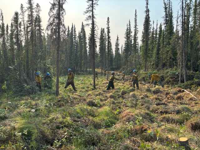
Turtle Fire (#243) – An inversion kept fire behavior to a moderate level throughout most of Sunday but prohibited aerial resources from supporting ground crews. Around 8 p.m., the inversion cleared and fire activity increased. With the increased visibility, scooper planes were able to drop several loads of water on the northern edge. Today, the Tatanka and Smith River hotshots plan to engage that same northern edge using direct tactics with support from aerial resources. Fire activity is expected to increase as the inversion breaks, but the expected change in weather will provide those ground crews with an opportunity to continue engaging in direct tactics in the coming days. The Alaska Native allotment boundary, near Mile 148 on the Steese Highway, lies to the north of that section of planned direct line. The indirect line around the allotment is continually being reinforced with pumps, hose, and removal of fuels.
The east side of the fire experienced moderated fire growth as it continues to advance into a flatter area with many water features. Big Sky Helitack has continued to prepare structures and allotments along the west bank of the Yukon River.
On the southwest side of the fire, the Black Hills Module continued to conduct firing operations along Birch Creek to keep the fire on the east side of the creek. In addition, resources patrolled the west side of the creek to look for and extinguish any spot fires in support of the planned firing operation
The Turtle Fire was started by lightning. It was reported on June 19 and is burning about 10 miles east of Central and 12 miles south of Circle.
Alligator Fire (#265) – Fire behavior is limited to creeping and smoldering, with some isolated tree torching in the interior of the fire as the inversion lifts. Lingering heat remains in the northwest portion of the fire, but crews have been able to accomplish a 100-foot mop up distance into the interior on almost all areas of the fire. Due to the progress made on the fire, the Smith River Hotshots were able to be reassigned to support operations on the Turtle Fire
The Alligator Fire is about 3 miles north of Central. It was started by lightning and was discovered on June 20. The fire is currently at 886 acres, with 25% containment.
Birch Fire (#256) – As seen with the other fires in the complex, fire behavior was moderated with the inversion in place, and increased for several hours as the inversion lifted. On the northwest portion of the fire, a pocket of fuel became active and slipped through the established indirect line. This portion of the fire that established beyond the line remains a low risk, as it will struggle to establish itself in the hardwood fuels. The fire remains in monitor status as it has otherwise held within the indirect fire lines. The southwest portion of the fire remains contained. Air resources assigned to the complex will report on the status of the fire as conditions allow. The Deadwood Fire (#214) is also being monitored. The Ketchem Fire (#240) and Little Mosquito Fire (#241) are out.
The Birch Fire, located 4 miles northwest of Circle, was discovered on June 20. The fire is at 256 acres, with 25% containment.
Buckley Bar (#264) – The fire is 17 miles southwest of Central, and is being added to the Ptarmigan Complex today due to the proximity and threat to nearby historic structures. Communication challenges exist due to terrain in the area, including a narrow and tight canyon. Today, a helitack crew is planning to assess the structures from the air and may begin working on the ground to set up pumps and hose for structure protection
The Buckley Bar fire was discovered on June 20. It was started by lightning.
A Level 1 “Ready” Alert remains in effect for the community of Central, the Steese Highway from Milepost 123 to Milepost 151, Circle Hot Springs Road and Circle Hot Springs, and Deadwood Creek Road. Drivers should expect traffic delays on the Steese Highway, Circle Hot Springs Road, and Deadwood Creek Road due to firefighting operations. A Level 1 “Ready” alert means: begin preparing for a potential evacuation; make plans for family members with special needs, pets, or livestock; gather essential items such as prescriptions, important documents, and valuables; and stay alert and watch for updates from local authorities.
NOTAM #06/201 is in place for the Central Airport (CEM): Increased air traffic 5,000 ft MSL and below within a 20 nautical mile radius of the Central Airport (CEM) due to firefighting aviation operations.
-BLM-
Need public domain imagery to complement news coverage of the BLM in Alaska? Visit our Flickr channel!
Learn more at www.blm.gov/Alaska, and on Facebook, Instagram, Twitter, and YouTube.
The BLM manages more than 245 million acres of public land located primarily in 12 western states, including Alaska, on behalf of the American people. The BLM also administers 700 million acres of sub-surface mineral estate throughout the nation. Our mission is to sustain the health, diversity, and productivity of America’s public lands for the use and enjoyment of present and future generations.
Categories: Active Wildland Fire, AK Fire Info, BLM Alaska Fire Service
