A lightning event over the Solstice weekend resulted in multiple new fire starts across Southwest Alaska. Updates on each incident are provided below:
Takotna Fire (#264)
While flying a cargo mission to the Nixon Fire (#227) on Sunday, June 21, a DFFP helicopter crew spotted a new wildfire approximately 18.5 miles north of McGrath. The fire, now named the Takotna Fire (#264) was estimated at 1 acre and burning in black spruce and muskeg.
Firefighters observed slow-moving, creeping fire behavior with occasional single trees torching along the perimeter. Due to limited firefighting resources and higher-priority incidents in the area, crews were unable to take immediate suppression action. The fire will be monitored and addressed as resources become available.
Vanderpool Fire (#256)
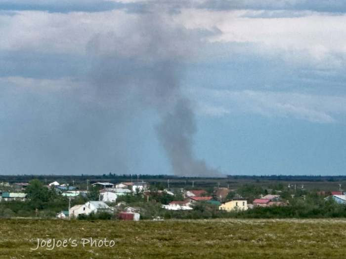
On Sunday, June 21, a DFFP helicopter responded to heat signatures detected by infrared satellite imagery approximately 9.5 miles east of McGrath. Upon arrival, the crew found a 5-acre wildfire burning in black spruce and tundra with active fire around the entire perimeter.
The helicopter began bucket operations while additional aerial resources, including air tankers and smokejumpers, were requested. Although smokejumpers were unavailable due to higher-priority incidents elsewhere, two air tankers responded and made multiple retardant drops to slow the fire’s spread.
The fire grew to approximately 10 acres, with retardant now surrounding about 75% of the perimeter. Ground firefighters remain on scene, working to extinguish hot spots within the fire perimeter and strengthen containment.
Nunsatuk Fire (#248)
On Sunday, June 21, a wildfire was reported approximately 24 miles north of Stony River near the Kuskokwim River. DFFP responded and initially estimated the fire at 8–10 acres, burning in spruce and mixed birch with slow-moving, creeping fire behavior.
Because of the fire’s proximity to an occupied homestead and another structure several miles downriver, smokejumpers were requested. Although they were initially unavailable, a crew was later dispatched to assess the fire.
After arriving at the incident, smokejumpers estimated the fire at approximately 50 acres, with active smoldering, creeping, and torching in heavy spruce and mixed hardwood fuels. Following a thorough evaluation of the challenging terrain, the crew determined that conditions were not suitable for the smokejumpers to deploy. Fire managers are evaluating other suppression tactics to address the fire.
Joaquin Fire (#238)
The Joaquin Fire (#238), located southwest of Takotna, was first reported Saturday, June 20, after smoke was spotted on the southwest side of Mt. Joaquin, about 8–10 miles from Takotna. Initial aerial observations estimated the fire at 5 acres, burning in black spruce and tundra with smoldering, creeping, backing, and occasional torching. Because of a nearby Native allotment, smokejumpers and air tankers were requested. While air tankers were unavailable, six smokejumpers successfully deployed to the fire. The fire later grew to approximately 30 acres but remains stable.
It showed minimal fire activity on Sunday, June 21. Firefighters reported continued burning along the fire’s edge but no significant growth potential. Water-scooping aircraft completed a full fuel cycle to help cool hot spots and support suppression efforts.
Kepangalook (#230)
The Kepangalook Fire (#230), located approximately 8 miles northeast of Bethel, was first reported by a pilot at approximately one-quarter acre, burning in tundra. Smokejumpers responded and, upon arrival, found the fire had grown to an estimated 6–7 acres. Fire behavior was primarily smoldering and creeping, with short flame lengths and low to moderate potential for further spread.
Six smokejumpers parachuted into the fire, secured the perimeter, and successfully contained the incident by 9:30 p.m. under light precipitation. The fire was officially called out on Sunday, June 21, and firefighters demobilized from the incident that day.
Nixon Fire (#227)
On Saturday, June 20, remote satellite heat detection identified a possible wildfire approximately 20 miles north of McGrath. A DFFP helicopter responded and located a 5–10 acre fire burning in patchy spruce with active fire behavior, including creeping, running, and group torching. Fire activity was most pronounced on the right flank, with smoldering observed on the left. No structures or other values were reported to be at risk.
Helicopter crews initiated bucket operations, and Air Attack coordinated additional suppression support using water-scooping aircraft to reduce fire intensity. By approximately 8:30 p.m., Air Attack reported no visible open flame, though the right flank continued to smolder. Helitack remained on scene as the fire was estimated at 12 acres, with surface fuels still holding heat. On Sunday, June 21, firefighters continued suppression and containment efforts, supported by a supply delivery to the incident.
Categories: Active Wildland Fire, Alaska DNR - Division of Forestry & Fire Protection (DFFP)
