On Wednesday afternoon, winds from the northeast increased fire activity on the western flank of the Shovel Creek Fire in the Shovel Creek drainage. Due to spotting embers, an 80-acre spot fire grew on the west side of Shovel Creek as the fire burned uphill into the 2009 Hardluck Creek Fire scar. Overall, the Shovel Creek Fire gained just over 700 acres in new growth on Wednesday and is now estimated at 1,622 acres, according to the Alaska Divison of Forestry.
Firefighters continued to engage in full suppression operations by constructing direct containment lines around the fire’s perimeter. Crews have deployed over 15 miles of firehose that is supported by large engines and water tenders filling portable water tanks on Murphy Dome. There were 345 personnel assigned to the fire as of Thursday morning.

Norm McDonald, incident commander for the Alaska Type 2 Green Incident Management Team, addresses a crowd of about 180 people at a community meeting regarding the Shovel Creek Fire at the Ken Kunkel Community Center on Wednesday night, June 26, 2019. Photo by Tim Mowry/Alaska Division of Forestry
Nearly 200 people attended a community meeting Wednesday evening for the Shovel Creek Fire; hosted by the Alaska Incident Management Team at the Kunkel Community Center pavilion. The Fairbanks North Star Borough Emergency Operations also shared resources and recommendations for the public.
On Thursday, crews will begin preparations along the north side of the Murphy Ridge for a firing operation that will connect the 2009 Hardluck Creek Fire scar and the 7 Mile Trail. Because of this work, travel on the Bennet Highway down to the Chatanika River boat launch may be delayed from 10 a.m. to 10 p.m. due to fire operations. Users of this road should plan accordingly.
Point protection preparations continue to be completed on the structures most immediately threatened to the north of the fire on the south side of the Chatanika River. Structure assessments continued in other areas along the Chatanika River to the north and west of the fire. Point Protection assessments in the five residential subdivisions south and east of the fire continued and water sources were established for point protection operations in these subdivisions.
The incident management team will continue to coordinate with Fairbanks North Star Borough to plan for any potential public evacuation needs. The communities of Martin subdivision, McCloud subdivision, Murphy subdivision, Lincoln subdivision, Perfect Perch Drive, and the Chatanika River corridor remain in Level 1 (Ready) evacuation status. Level 1 evacuation status is not an evacuation order; rather it is a notice for residents should be ready for a potential evacuation.

A smoke column rises from the 665-acre Nugget Creek Fire at 10 p.m. Wednesday night, June 26, 2019 near milepost 36 of Chena Hot Springs Road.. Photo by Tim Mowry/Alaska Division of Forestry
The Nugget Creek Fire was active and grew on Wednesday to 665 acres. Aerial monitoring of the fire continues on a daily basis. On Wednesday the fire was active and spread to the east and south, paralleling the Chena Hot Springs Road. The fire is burning in a Limited Protection Area in the Chena River State Recreation Area near milepost 36 of Chena Hot Springs Road., approximately 35 miles east of Fairbanks.
The Nugget Creek Fire will continue to be monitored from the air and ground on Wednesday. On Thursday, a rappel crew will be inserted into the area to begin setting up sprinkler systems to protect several cabins, including the Nugget Creek Cabin. Firefighters will continue to identify and assess values at risk in the area, and inform the public of ongoing recreational area closures.
WEATHER: High pressure will continue to dominate over the area through Friday. Relative humidity levels at valley floors will recover better than at mid-ridge and ridge tops. Slight increase in cloud cover will keep the relative humidity trend slightly higher than Wednesday’s levels. Wind will be drainage dominated during the late evening and overnight hours.
SAFETY: An increase in fire activity for several area fires is contributing to increased smoke in the Fairbanks area. With cooler temperatures and higher relative humidity values overnight, motorists should expect smoke to settle in the low lying areas – particularly in the morning hours. Residents in the area are asked to avoid the Murphy Dome area due to the firefighting activity and the potential for interfering with fire personnel. A Temporary Flight Restriction is in place in the air space over the fire. Pilots are advised to check NOTAMS at https://tfr.faa.gov/save_pages/detail_9_0263.html.
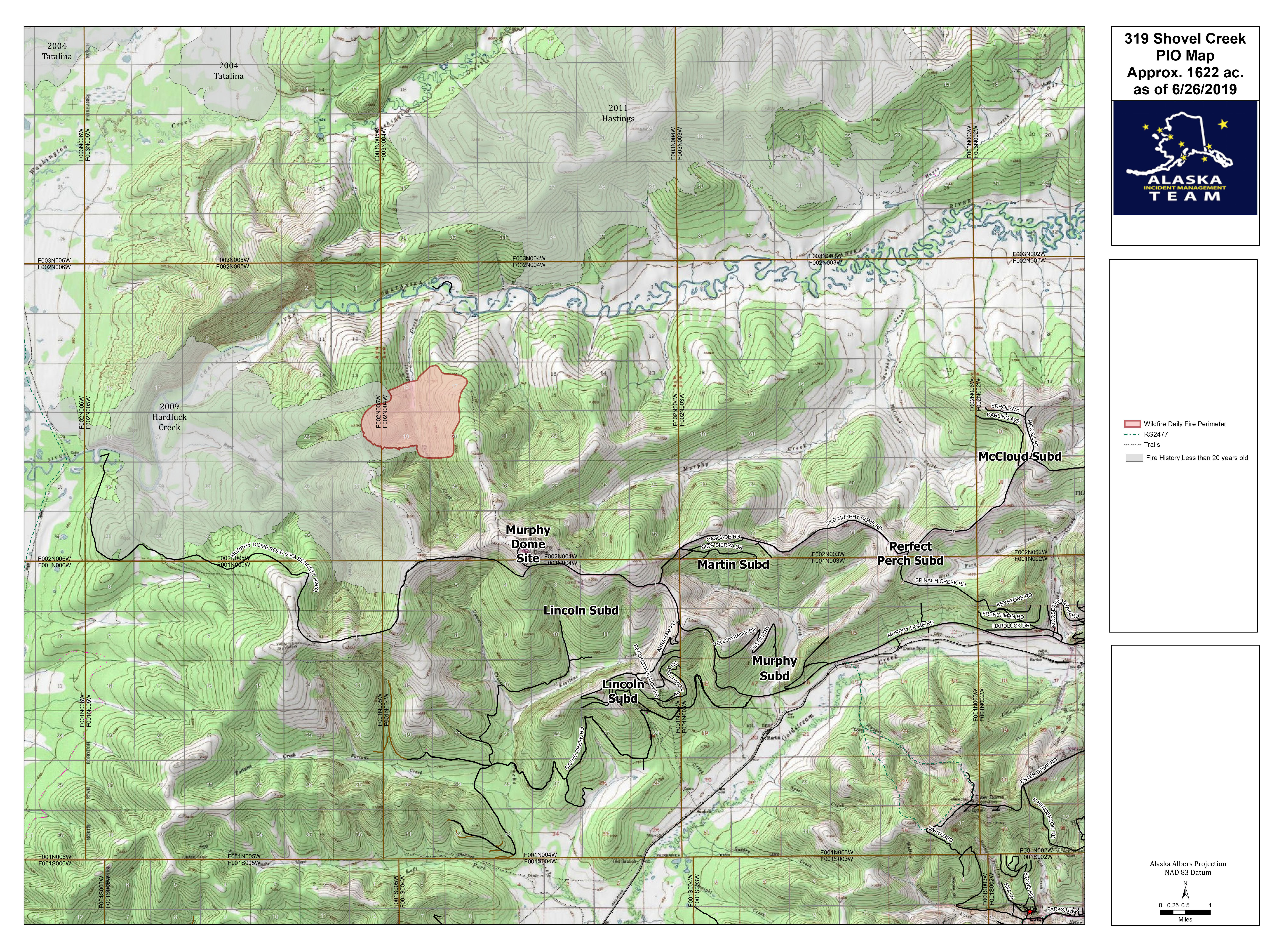
A map showing the location and perimeter of the 1,622-acre Shovel Creek map. For a downloadable PDF version of the map go to Shovel Creek Fire PDF map June 27

A map showing the location and perimeter of the 665-acre Nugget Creek Fire. For a downloadable PDF version of the map go to Nugget Creek Fire PDF map June 27.
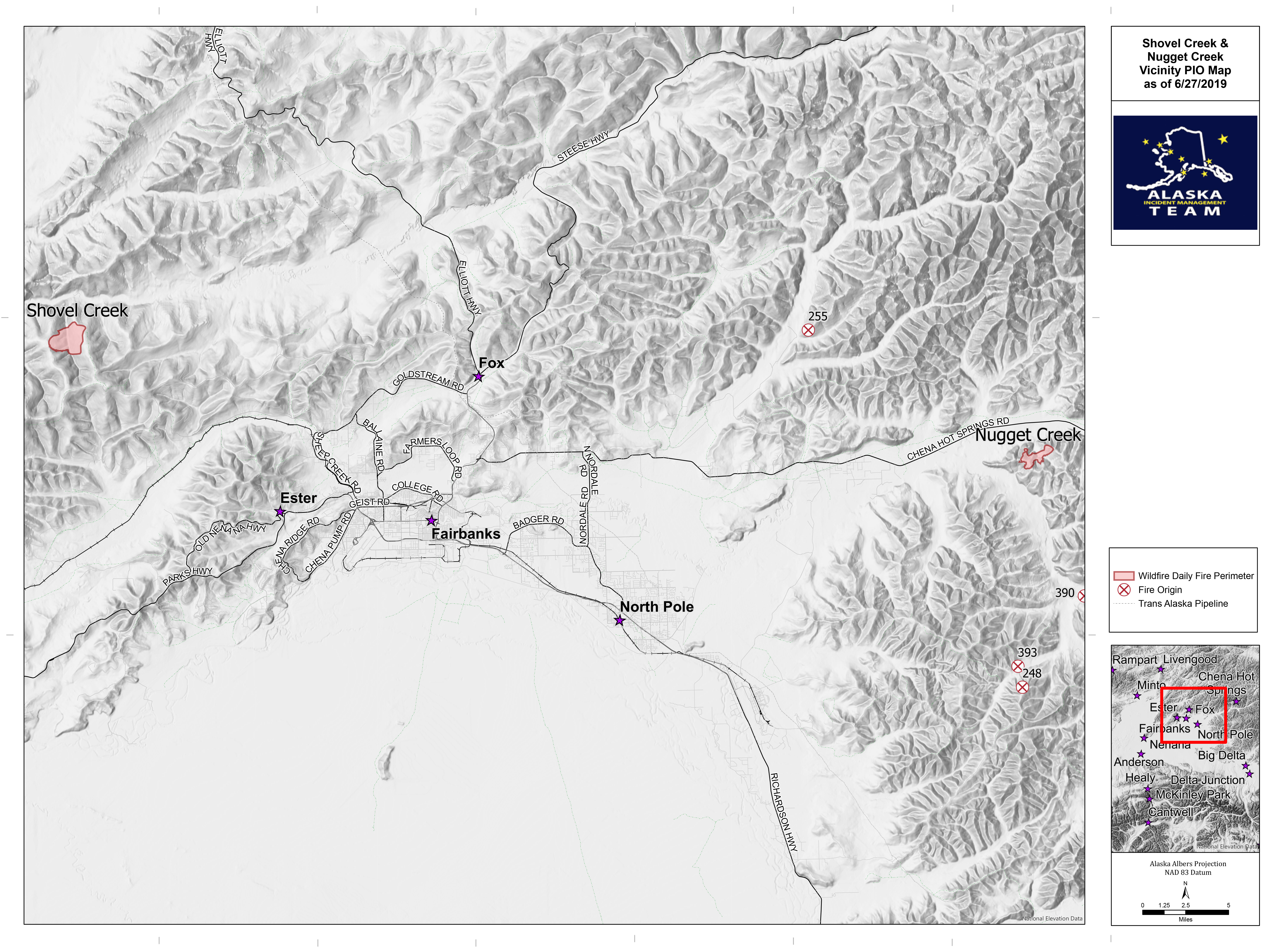
A map showing the locations of the Shovel Creek and Nugget Creek fires. For a downloadable PDF version of the map go to Shovel Creek and Nugget Creek fires PDF vicinity map June 27
Categories: Active Wildland Fire, AK Fire Info
