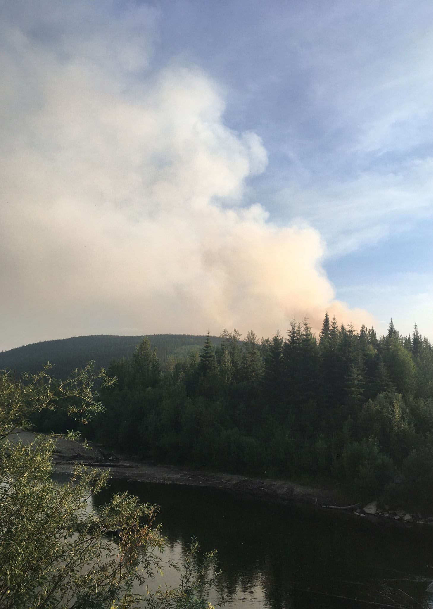
On Thursday, the Shovel Creek Fire continued to burn actively in black spruce within the Shovel Creek basin. Despite cooler temperatures, increased cloud cover, and light winds, some individual and group tree torching did occur. As of Friday morning, the fire was estimated at 2,307 acres, an increase of about 700 acres, accoding to the Alaska Division of Forestry.

Fire activity on the northern flank of the Shovel Creek Fire as seen on Thursday afternoon, June 27, 2019. Alaska Division of Forestry photo
Firefighters implemented a change in their suppression tactics on Thursday to keep the fire within the Shovel Creek drainage after the previous evening’s extreme fire behavior and rapid fire spread around containment lines on the south side of the fire. Crews held containment lines on the east side and worked directly on the fire’s edge on the north side of the fire. There were 446 personnel assigned to the fire as of Friday morning.
The Shovel Creek Fire burned up to the 2009 Hardluck Creek Fire scar on the west side, where the fire behavior diminished significantly in the lighter vegetation. On the south side of the fire, crews prepared for indirect firing operations on the north side of the Murphy Ridge to connect the Hardluck Creek Fire scar and the 7 Mile Trail. Alternate containment lines were identified should the fire spread south or east of the Shovel Creek drainage. Point protection operations continued in the Chatanika River corridor in the five subdivisions south and east of the fire in preparation for point protection in those areas.

Two members of the Helena Interagency Hotshot Crew prepare to head to the fireline on the Shovel Creek Fire on Thursday, June 27, 2019. Alaska Divvision of Forestry photo
Today, crews will continue to hold and improve the containment line on the east and south sides of the fire in preparation for indirect firing operations in the Shovel Creek drainage northwest of Murphy Dome. Because of this work, travel on the Bennet Highway down to the Chatanika River boat launch may be delayed from 10:00 am to 10:00 pm due to fire operations. Motorists should plan accordingly.
Crews will also continue building and improving containment lines on the north side of the fire. Construction of an alternate containment line will begin east of the fire in the Murphy Creek drainage using dozers. Structure protection groups will continue point protection and structure assessments in all areas where values at risk are located in the fire area.
The incident management team will continue to coordinate with Fairbanks North Star Borough to plan for any potential public evacuation needs. The communities of Martin subdivision, McCloud subdivision, Murphy subdivision, Lincoln subdivision, Perfect Perch Drive, and the Chatanika River corridor remain in Level 1 (Ready) evacuation status. Level 1 evacuation status is not an evacuation order; rather it is a notice for residents should be ready for a potential evacuation.
The Nugget Creek Fire actively burns around 10 p.m. on Wednesday night, June 26, 2019 in this photo taken near Mile 37 Chena Hot Springs Road. Photo by Tim Mowry/Alaska Division of Forestry
This will be the final update on the Nugget Creek Fire from the Alaska Incident Management Team. The Nugget Creek Fire, burning in the Chena River State Recreation Area east of Fairbanks, will be returned to the Fairbanks Area forestry office on Saturday. Information about the fire will continue to be available on http://www.akfireinfo.com, InciWeb (https://inciweb.nwcg.gov/incident/6401/), and information sign boards in the surrounding community.
On Thursday, the fire was active in black spruce, but fire behavior was only minimal in mixed hardwoods and open areas. Smoke from the Nugget Creek Fire could be seen from Chena Hot Springs Road and the surrounding area on Tuesday. A rappel crew was inserted into the fire area to complete several structure protection measures around cabins, including the Nugget Creek public-use cabin. The crew installed pumps and hose to be used to protect the cabins should they be needed.
Today, the rappel crew will complete the structure protection measures they began the day before. Once that work is completed, the fire will return to being monitored by the air or ground as needed. On Saturday, the Nugget Creek Fire will be returned to the Fairbanks Area forestry office. Information about the fire will continue to be available on http://www.akfireinfo.com, InciWeb (https://inciweb.nwcg.gov/incident/6401/), and information sign boards in the surrounding community.
Due to heavy smoke and increased fire activity, Alaska State Parks has closed the Granite Tors Trail located at mile 39 Chena Hot Springs Road. Drivers are cautioned to watch for fire equipment and to be prepared for reduced visibility along Chena Hot Springs Road. For information on current road conditions, visit http://511.alaska.gov.
WEATHER: A front to the northwest will move out of the area this evening. High pressure will build back over the area with clearing skies. Near Red Flag conditions are expected on Friday and Saturday during the afternoon and evening.
SAFETY: An increase in fire activity for several area fires is contributing to increased smoke in the Fairbanks area. With cooler temperatures and higher relative humidity values overnight, motorists should expect smoke to settle in the low lying areas – particularly in the morning hours. Residents in the area are asked to avoid the Murphy Dome area due to the firefighting activity and the potential for interfering with fire personnel. A Temporary Flight Restriction is in place in the air space over the fire. Pilots are advised to check NOTAMS at https://tfr.faa.gov/save_pages/detail_9_0263.html.
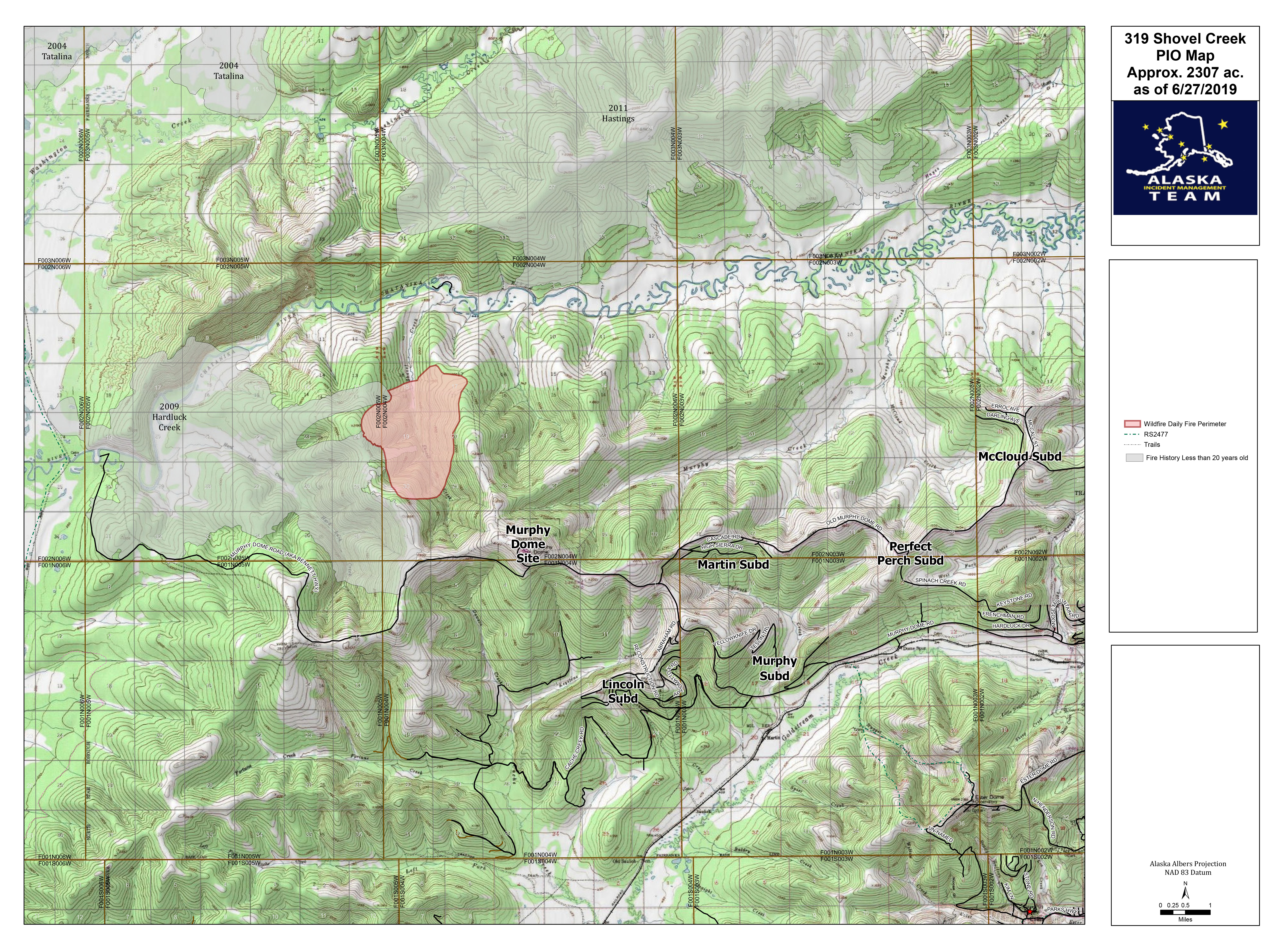
A map showing the location and perimeter of the 1,550-acre Nugget Creek Fire as of Thursday, June 27, 2019. For a downloadable PDF version of the map go to Shovel Creek Fire PDF map June 28

A map showing the location and perimeter of the 1,550-acre Nugget Creek Fire as of Thursday, June 27, 2019. For a downloadable PDF version of the map go to Nugget Creek Fire PDF map June 28
Categories: Active Wildland Fire, AK Fire Info
