9 p.m. update (last update for June 13, 2020): Due to moderated fire behavior, the evacuation order for the O’Connor Creek Subdivision, which includes Hattie Creek Road, Resolution Road, Determination Drive, and Adit Lane, has been improved to a Level 1: Ready. This means residents should still be ready in case fire activity because Any Creek Fire (#236) burning north of the Old Murphy Dome Road is still uncontained
Rain moved into the area starting at about 6:30 p.m. and subdued the Any Creek Fire burning 10 miles north of Fairbanks and about 7 miles west of the intersection of the Elliott Highway. Thundercells moved over the fire, bringing rain and erratic winds and grounding the fleet of aircraft that were assaulting the fire from above. Firefighters are on the ground, taking advantage of the moderated fire behavior to build more fireline and searching for spots where airborne fire embers crossed the line and into the unburned vegetation ahead of the fire. The Winema Interagency Hotshot Crew from Lakeview, Ore. were mobilized to help with the suppression efforts. There are about 95 people assigned to the fire.
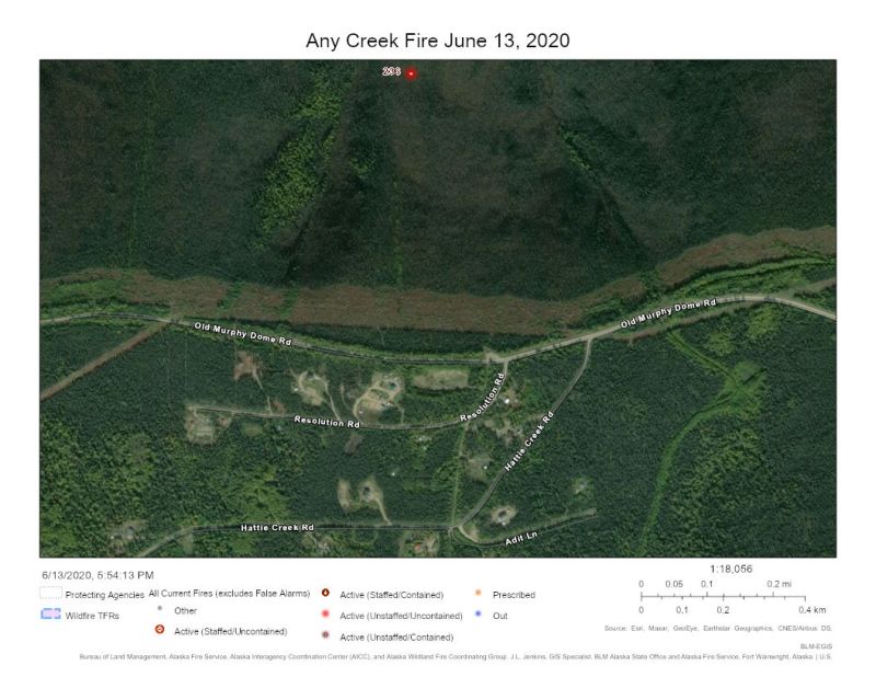
The fire is burning through predominately black spruce and had grown to an estimated 35 acres by 7:30 p.m. The fire is burning up a drainage toward the Old Murphy Dome Road, but was still about ¾ of a mile north of the road. A fuel break and the road and stand in the way of the fire and the subdivision.
A Level 2: Set evacuation warning had been in place for the O’Connor Creek Subdivision. This means residents should pack valuable items such as paperwork, pets, medication and enough emergency supplies for at least three days in anticipation a Level 3: Go evacuation order is given at a moment’s notice.
The Any Creek Fire is burning about 3 miles north of the Goldstream Valley Road and about 5 miles northeast of the Goldstream Valley and Ballaine Road intersection. It is 8 miles east of the 2019 Shovel Creek Fire.

The Any Creek Fire is burning north of the Old Murphy Dome Road about 7 miles west of the Elliott Highway. This photo was taken at 4:17 p.m. on June 13, 2020. Photo by Rick Thompson, BLM AFS 
The Any Creek Fire is burning north of the Old Murphy Dome Road about 7 miles west of the Elliott Highway. This photo was taken at about 5:30 p.m. on June 13, 2020. Photo by Rick Thompson, BLM AFS
5 p.m. update: There is a Level 2: Set evacuation notice for the Hattie Creek Subdivision located south of Old Murphy Dome Road about 7 miles west of the Elliott Highway. This notice is for people to prepare for an evacuation order that could come at a moment’s notice. The Old Murphy Dome Road is closed at the Elliott Highway to all non-local traffic due the amount of firefighting resources traveling in the area working on the Any Creek Fire (#236) is burning north of the road. The fire was estimated to be 25-35 acres.
All available air resources, 16 smokejumpers; the Type 2 UAF Nanook Fire Crew, firefighters on the Boise Blackhawk helicopter module; Alaska Division of Forestry and local volunteer fire department engines are working on the fire. The fire was burning in a southerly direction up a drainage toward the Old Murphy Dome Road. However, the road and a fire break stand between the fire and the Hattie Creek subdivision.
Residents under this evacuation warning are to assemble valuables such as paperwork, pets, medication and enough emergency supplies to last three days in case they are told to leave the area.
Evacuation levels are as follow:
Level 1, Be Ready: Create and maintain defensible space and harden your home against flying embers.
Level 2, Get Set: Prepare your family and home ahead of time for the possibility of having to evacuate.
Level 3, Be Ready to GO!: Take the evacuation steps necessary to give your family and home the best chance of surviving a wildfire.
📲 The Fairbanks North Star Borough Emergency Management established a text-based notification system to alert users in case of evacuations associated with wildfires. Text “FNSB2020wildfire” to the 226787 to opt in to these alerts. 🤳
Original information at 3:20 p.m.: Smokejumpers and aircraft are working on a fire burning north of Old Murphy Dome road about 7 miles west of the Elliott Highway. The fire is burning north of the Resolution Road and Old Murphy Dome intersection about 7 miles from the Elliott Highway. Alaska State Troopers are en route and will close the Old Murphy Dome Road in the area to all but firefighter personnel working on suppressing the Any Creek Fire (#236).
Information will be updated as it is made available. For more information, contact the Alaska Interagency Fire Information Office at (907)356-5511.
Categories: Active Wildland Fire, AK Fire Info, Alaska DNR - Division of Forestry & Fire Protection (DFFP)
