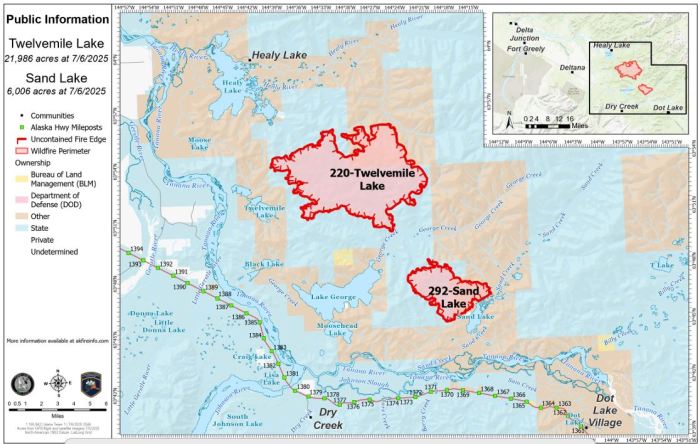
Fire activity increased slightly on Sunday, with both the Twelvemile Lake (#220) and Sand Lake (#292) fires showing some growth. Twelvemile Lake Fire is now estimated at 21,986 acres, an increase of 2,330 acres. The Sand Lake Fire has grown to 6,006 acres, up by 818 acres. Total personnel remains at 62, and incident objectives are unchanged.
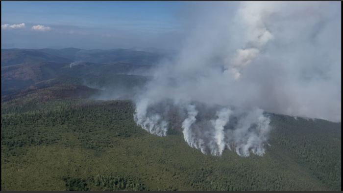
Crews observed isolated fire activity overnight and into the day, particularly in areas of black spruce and white spruce on the northern perimeter of the Twelvemile Lake fire that produced visible smoke columns. Some short uphill runs and light spotting occurred but were largely held in check by natural features and fuels. Helicopter reconnaissance confirmed most fire movement stayed within expected areas, with no management action points crossed. In wildfire operations, a management action point is a predetermined location or condition on the landscape that prompts a specific tactical response or change in strategy, such as moving resources, initiating evacuations, or transitioning to a new suppression phase.
Yesterday the crew positioned at Sand Lake worked near an allotment boundary to contain a hot spot, with water from helicopter bucket drops, and saw line work to prevent further spread. Elsewhere, pumps remain operational and ready should conditions warrant.
With rain in the forecast and increasing humidity, the team is preparing for the potential to begin crew shuttles and backhaul missions from the remote camps. Divisions are coordinating plans for sling loads, aircraft, and boat support, with execution likely depending on Monday’s weather.
Weather Outlook:
Showers will continue through Monday, becoming widespread by afternoon with isolated thunderstorms possible. Winds will be out of the west at 5–8 mph, gustier near storms. Highs will reach the mid-60s with humidity climbing to 58%. Conditions are expected to remain cloudy and wet throughout the week.
Categories: Active Wildland Fire, AK Fire Info, Alaska DNR - Division of Forestry & Fire Protection (DFFP)
