A strong band of thunderstorms with abundant lightning again covered a broad swath of the state on Wednesday, from the southwest to northeast. A dense concentration of lightning strikes was recorded in the Brooks Range and the northern reaches of the Yukon Flats. Rain was heavy in some locations and other nearby sites received little to no precipitation.
Western Alaska remains extremely dry. Red Flag Warnings for critical fire weather conditions are issued again today for the Upper Kobuk Valley in the northwestern Alaska and the Upper and Lower Koyukuk valleys. Fuels in the northern interior are very dry and remain receptive to burning.
Firefighters are working along the Elliott and Taylor highways in central and eastern Interior. Please watch for and yield to firefighting traffic. Particularly for the Taylor Highway area, do not stop on the highway to look at the fire.
Staffed Fire Updates:
The Canyon Fire (#174) finally received light rain on Wednesday, with overcast skies lingering throughout the day. Fire activity was minimal, with wispy smoke visible. The burned area is estimated at 1001 acres. The Kilauea Type 2 Wildland Fire Module from Hawaii is working with the U.S. Wildland Fire Service – Alaska Chena Hotshots and smokejumpers improving control lines on the Native allotment to the northeast of the fire. Crews finished point protection measures on the other Native allotment, cabins, and a fish camp. The areas of point protection are still not immediately threatened by the fire, but conditions remain favorable for fire growth. Rampart, the nearest community, is approximately 20 miles east of the fire and south of the Yukon River. Smoke is visible to both boaters and aviators traveling the Yukon River corridor.
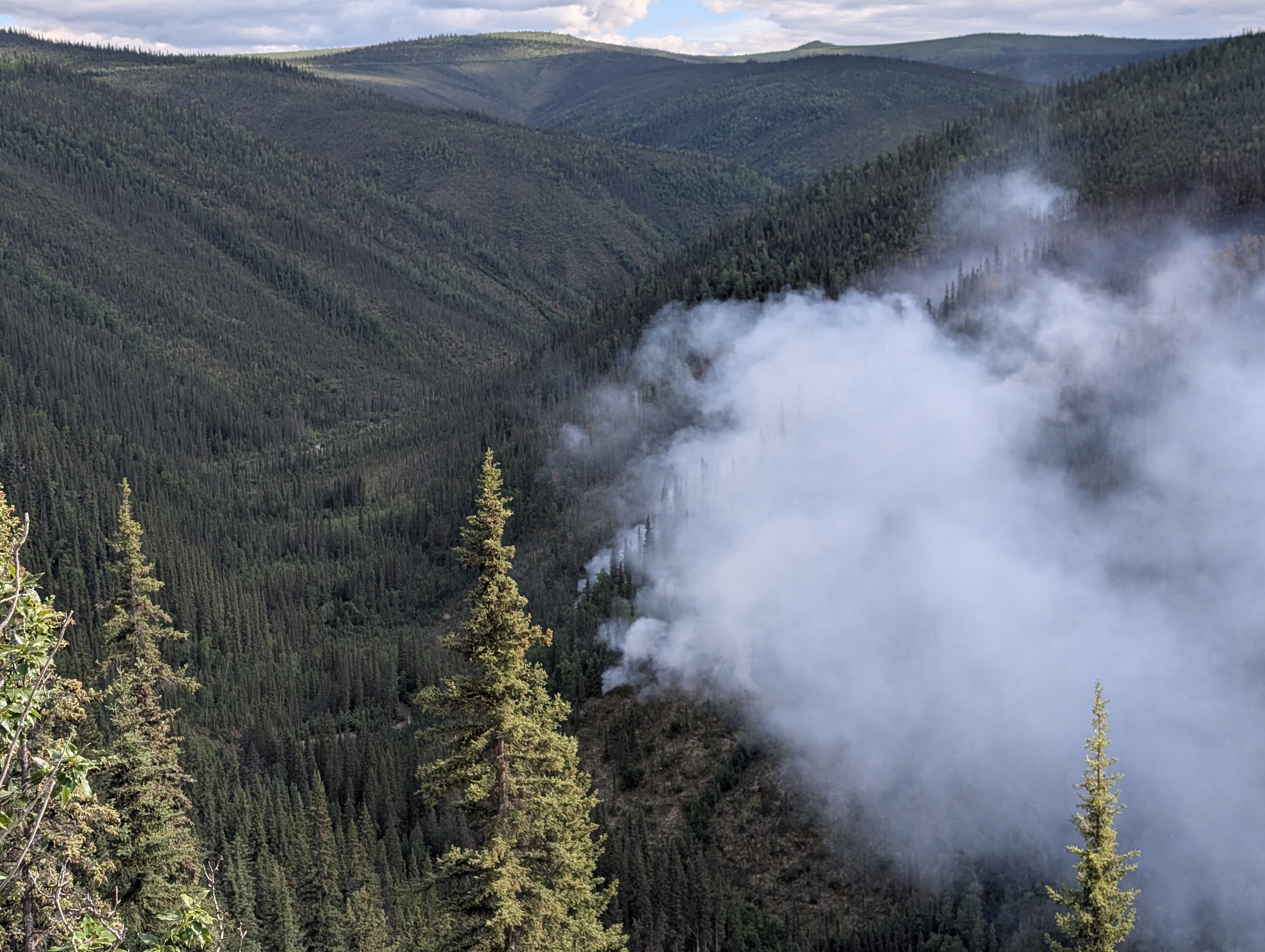
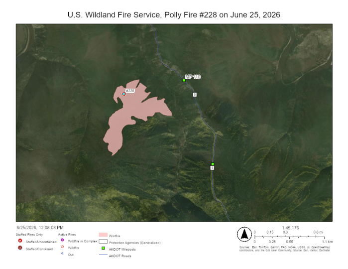
On Wednesday night, the Polly Fire (#228) was still holding west of Polly Creek about 1/3 mile from the Taylor Highway in the Fortymile Country near milepost 110. Firefighters with the Alaska Range Suppression Module from Denali National Park set up hoses and sprinklers to protect structures in the area. Fire activity was minimal in the morning, but isolated torching was observed late in the day as the temperature rose and the relative humidity dropped. Firefighters will continue structure protection work today. A helicopter will also drop water on the eastern flank of the fire to keep it west of the creek. The Polly Fire was detected on June 20 after a significant lightning event. It is about 21 miles north of Chicken and 35 miles south of Eagle. Smoke may be visible from the Taylor Highway corridor and communities nearby. Please watch for and yield to firefighting traffic in the area, and do not stop on the highway to look at the fire.
Fire managers have changed tactics on the Betula Fire (#266) from full suppression to a point protection strategy for values at risk within 5 miles after activity picked up significantly and fire spotted in numerous places. This will allow firefighting resources to be reassigned to other incidents where life and property are threatened. The Betula Fire is burning in an area that was impacted by the 2025 Buckley Bar Fire and has heavy dead and down timber. It is estimated at 80 acres and is about 21 miles southeast of Central. Firefighters will work Thursday to protect any values at risk in the area.
The Shorty Fire (#271) was thoroughly gridded on Wednesday and no hot spots were identified. A heavy rain soaked the fire area in the late afternoon. It is considered 100% contained after burning approximately 7 acres. Smokejumpers are returning to Fairbanks today.
Twelve Smokejumpers were dispatched to a new fire late Wednesday approximately 14 miles west of milepost 146 on the Dalton Highway and 16 miles northeast of Bettles. The Mailbox Fire (#290) was estimated at 200 acres, and was actively burning in spruce, sending heavy smoke into the air. Additional resources have been requested, including air support, if cloud cover permits.
Rain again cooled the Elliott Complex fires on Wednesday, reducing visible fire activity. Firefighters continue to seek out and cool remaining hotspots.
Applegate Fire (#235) – Smokejumpers and the USWFS North Stars Type 2 Fire Crew are working on this fire, estimated at approximately 110 acres, with approximately 50% containment.
Truce Fire (#243) – The Nulato Hills 1 and 2 Type 2 Contract Crews were delayed in arriving to the fire yesterday but are expected to arrive today and begin working on hotspots and mop-up. The fire is estimated at approximately 50 acres.
Hutlitakwa (#240) is 100% contained. Starvation (#241), Goose (#242), and Lochenyatth (#249) fires are in monitor status.
Contact Public Information Officer Joan Kluwe at Joan_Kluwe@firenet.gov or (907)356-5510 for more information.
-USWFS-
U.S. Wildland Fire Service, P.O. Box 35005 1541 Gaffney Road, Fort Wainwright, AK 99703
Need public domain imagery to complement news coverage of the USWFS in Alaska? Visit our Flickr channel!
Learn more online, and on Facebook.
Categories: Active Wildland Fire, AK Fire Info, USDA Forest Service, Region 10
