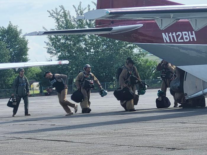
With prolific lightning across the state for over a week, including over 9,000 strikes yesterday, new fires continue to ignite across the U.S. Wildland Fire Service management areas in Western, Eastern, Northern, and Interior Alaska. Air resources have provided crucial initial attack response, aiding smokejumpers responding to new starts.
Thunderstorms with lightning are forecast for today. Red Flag Warnings for critical fire weather conditions are issued for areas from southwest Alaska, northern and eastern interior areas. Lightning in dry fuels is anticipated.
All new fires — nine on Thursday and two this morning — occurred in USWFS’s 191.5-million-acre protection area covering most of northern Alaska. Seven of those started in areas designated under the Limited Management Option, which is one of the four wildfire management response levels used across Alaska. The Limited option allows wildfire to play its natural ecological role such as renewing vegetation, improving wildlife habitat, and maintaining healthy ecosystems. Fires in these typically remote areas are monitored by routine reconnaissance flights. Even in Limited areas, managers identify key sites such as Native allotments, cultural sites, cabins, communication structures, or other sensitive resources. If a fire approaches one of these identified values, the response shifts to point protection. This means firefighters focus efforts on protecting the specific site, not suppressing the main fire. Alaska’s size and remote terrain make it impractical and often unnecessary to suppress every fire. Letting the fire perform its natural ecological function reduces long‑term fuel loads, lowers future fire severity, and supports landscape resilience.
Firefighters continue working along the Elliott and Taylor highways in central and eastern Interior. Please watch for and yield to firefighting traffic. Particularly for the Taylor Highway area, do not stop on the highway to look at the fire.
Staffed Fire Updates:
Clouds helped to cool the Canyon Fire (#174) most of Thursday as firefighters continued work on point protection for the allotment to the northeast of the fire. Light smoke was observed yesterday after sunshine broke through the clouds and the temperature reached 75 degrees. Firefighters estimate substantial heat remains in this fire area, with conditions remaining favorable for fire growth. The burned area is estimated at 1001 acres. The areas of point protection are still not immediately threatened by the fire. Rampart, the nearest community, is approximately 20 miles east of the fire and south of the Yukon River. Smoke is visible to both boaters and aviators traveling the Yukon River corridor.
Firefighters continue to hold the Polly Fire (#228) west of Polly Creek with the help of water drops from a helicopter. The fire is still roughly 1/3 mile from the Taylor Highway near milepost 110 in the Fortymile country. The Alaska Range Suppression Module from Denali National Park & Preserve set up hoses and sprinklers on Thursday to protect a cabin from potential fire impacts. They plan to complete the same work today on another cabin in the area. They will also rely on support from the helicopter today to keep the fire on the west side of the creek.
A U.S. Forest Service Uncrewed Aircraft System Module from Boise, Idaho, has been assigned to the incident as well. They will use their UAS or drone today to conduct reconnaissance, mapping, and infrared flights, providing fire managers with additional information about the fire’s progression and activity.
The Polly Fire was detected on June 20 after significant lightning moved through the area. It is about 21 miles north of Chicken and 35 miles south of Eagle. Smoke may be visible along the Taylor Highway corridor and in nearby communities. Please watch for and yield to firefighting traffic in the area, and do not stop on the highway to look at the fire.
Twelve smokejumpers are assigned to the Betula Fire (#266), which is located about 21 miles southeast of Central. On Thursday, a reconnaissance flight was conducted to scout cabins upriver and downriver from the fire. Following a point protection strategy, the smokejumpers will visit the cabin sites today to determine the amount of work and equipment needed to prepare and plumb them with hoses and sprinklers. The Betula Fire is burning in an area that was impacted by the 2025 Buckley Bar Fire and has heavy dead and down timber. It is estimated at 75 acres.
Numerous passes by single engine and multi-engine water scooping aircraft helped hold the Mailbox Fire (#290) within the current perimeter, wetting over 2/3 of the active perimeter on Thursday. Smokejumpers worked on the right flank, cutting control line and establishing hose lays. The Tatanka Hot Shots from South Dakota are scheduled to arrive on the incident this afternoon. The fire was estimated at 200 acres, 10% containment. It is located approximately 14 miles west of milepost 146 on the Dalton Highway and 16 miles northeast of Bettles.
Late last night six smokejumpers began initial attack on the Kanuti Fire (#304), now estimated at 60 acres. It was checked last night on the east and west flanks by natural water features. The north side of the fire is the head, which is actively burning in black spruce. The fire is located approximately 9 miles southeast of Allakaket and approximately 1 mile east of a Native allotment. Today firefighters are working on point protection for the allotment, with support from air attack and water scooping aircraft.
Elliott Complex – Firefighters continue to grid, seeking out and cooling remaining hotspots. The complex includes:
- Applegate Fire (#235) – Smokejumpers and the USWFS North Star Type 2 Fire Crew are working on this fire, estimated at approximately 110 acres, with approximately 50% containment.
- Truce Fire (#243) – The Nulato Hills 1 and 2 Type 2 Contract Crews are working on hotspots and mop-up. The fire is estimated to be approximately 50 acres.
- Hutlitakwa (#240) is 100% contained. Starvation (#241), Goose (#242), and Lochenyatth (#249) fires are in monitor status.
Contact Public Information Officer Joan Kluwe at Joan_Kluwe@firenet.gov or (907)356-5510 for more information.
-USWFS-
U.S. Wildland Fire Service, P.O. Box 35005 1541 Gaffney Road, Fort Wainwright, AK 99703
Need public domain imagery to complement news coverage of the USWFS in Alaska? Visit our Flickr channel!
Learn more online, and on Facebook.
Categories: Active Wildland Fire, AK Fire Info, US Wildland Fire Service

