Fire activity on the Roundabout Complex continues to be driven by the Moldy Fire (#279). The complex is now mapped at 35,254 acres, with no growth or changes reported on the other fires. Firefighters remain focused on protecting values at risk, particularly Native allotments and structures along the Koyukuk River.
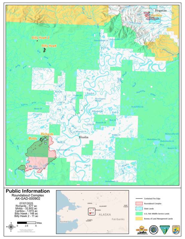
Moldy Fire (#279) – Firefighters continued implementing suppression strategies on multiple fronts yesterday. The Zigzag Hotshots worked west of the fire and will continue up along the Dagitli River to begin prep on the next allotment. The Plumas Hotshots split into two squads: one engaged a corridor of spruce fuel along the Richards Slough allotment, while the other used direct tactics on the fire’s northeast shoulder to stop northern progression. Both efforts will continue today. The Nulato Hills crew was demobilized yesterday and received a stellar evaluation for their work performance. Their hard work and professionalism were greatly appreciated on this incident.
Caribou Fire (#128), Richards Fire (#251), Billy Hawk Fire (#182), and Billy Hawk 2 Fire (#191) – No changes reported. All four fires remain in monitor status with no new activity.
Safety – A Red Flag Warning is in effect today due to abundant lightning, increasing the risk of new fire starts and placing additional strain on resources. A Red Flag Warning means that conditions are occurring or will occur which could lead to the development of large and dangerous fires. The health and safety of the public and our firefighters is always the highest priority of the Northern New Mexico IMT.
To print this update, find a PDF version here.
-BLM-
Bureau of Land Management, Alaska Fire Service
P.O. Box 35005 1541 Gaffney Road, Fort Wainwright, AK 99703
Need public domain imagery to complement news coverage of the BLM Alaska Fire Service in Alaska? Visit our Flickr channel!
Learn more at http://www.blm.gov/AlaskaFireService, and on Facebook.
The Bureau of Land Management Alaska Fire Service (AFS) located at Fort Wainwright, Alaska, provides wildland fire suppression services for over 240 million acres of Department of the Interior and Native Corporation Lands in Alaska. In addition, AFS has other statewide responsibilities that include: interpretation of fire management policy; oversight of the BLM Alaska Aviation program; fuels management projects; and operating and maintaining advanced communication and computer systems such as the Alaska Lightning Detection System. AFS also maintains a National Incident Support Cache. The Alaska Fire Service provides wildland fire suppression services for America’s “Last Frontier” on an interagency basis with the State of Alaska Department of Natural Resources, USDA Forest Service, National Park Service, Bureau of Indian Affairs, U.S. Fish and Wildlife Service, and the U.S. Military in Alaska.
Categories: Active Wildland Fire, AK Fire Info, BLM Alaska Fire Service
