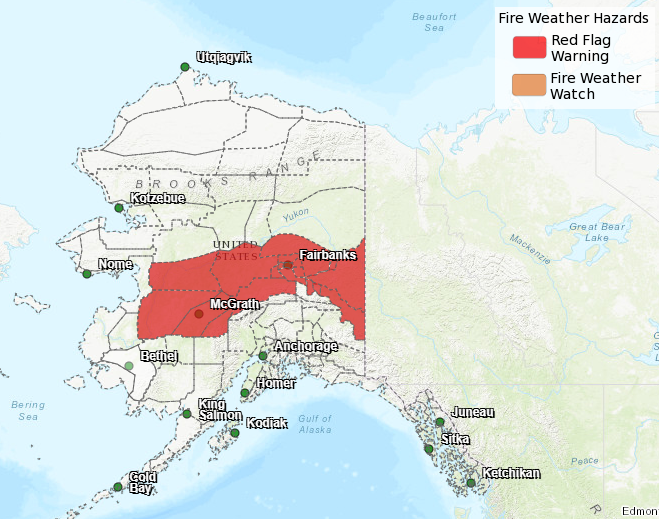
Over 4,000 lightning strikes were recorded across Alaska yesterday. Additional thunderstorms are forecast for today and through the weekend. Fuels are very dry, with good potential for new fires to start. Red Flag Warnings are issued through Sunday for interior to eastern Alaska.
While lightning strikes often ignite wildfires the moment they hit the ground, that is not always the case. Some fires, called holdovers or sleepers, don’t reveal themselves for days after lightning strikes. Holdover and sleeper fires can smolder below the surface for several days until temperatures warm, vegetation dries, and wind breathes life into the smoldering hot spot. Call 911 to report smoke or fires.
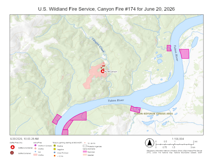
The U.S. Wildland Fire Service Smokejumpers and Chena Hotshots continue to improve control lines and set hose lays to protect two Native allotments, cabins, and a fish camp in the vicinity of Canyon Fire (#174). These areas of point protection are still not immediately threatened by the fire, but conditions are still favorable for fire growth. The fire was active on the north end yesterday, burning in the green pocket between the two arms of the fire and Canyon Creek.
Rampart is the nearest community, which is approximately 20 miles east of the fire and south of the Yukon River. Smoke is visible to both boaters and aviators traveling the Yukon River corridor.
Since the Canyon Fire is in a Limited Management Option Area, it is generally allowed to play its natural ecological role unless it threatens identified sites of value. However, Native allotments receive full protection status. Firefighters are focusing on protecting allotments and structures without directly engaging the main fire.
Contact Public Information Officer Joan Kluwe at Joan_Kluwe@firenet.gov or (907)356-5510 for more information.
-USWFS-
U.S. Wildland Fire Service, P.O. Box 35005 1541 Gaffney Road, Fort Wainwright, AK 99703
Need public domain imagery to complement news coverage of the USWFS in Alaska? Visit our Flickr channel!
Learn more online, and on Facebook and Twitter.
Categories: Active Wildland Fire, AK Fire Info, US Wildland Fire Service
